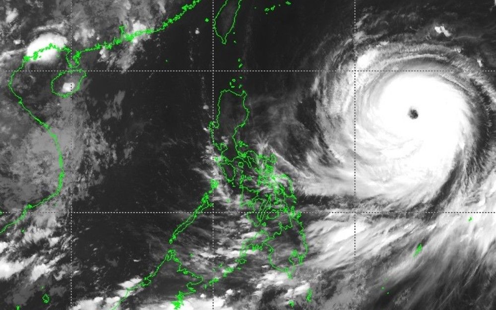
Super Typhoon Inday Enters PAR, Signal No. 1 Raised Over Parts of Luzon
Environment
2026年7月8日
4
Philstar Nation

Super Typhoon Inday Enters PAR, Signal No. 1 Raised Over Parts of Luzon

AI サマリー

Super Typhoon Inday has entered the Philippine Area of Responsibility, prompting the hoisting of Signal No. 1 over parts of Luzon. With maximum sustained winds of 185 kph, strong to gale-force gusts are expected in coastal and upland areas.

A powerful cyclone with winds reaching 185 kilometers per hour near the center has entered the Philippine Area of Responsibility (PAR) on Wednesday morning, July 8. The state weather bureau PAGASA has raised Signal No. 1 over parts of Luzon in response to the super typhoon, locally named "Inday." Inday, last spotted 1,405 kilometers east of Northern Luzon as of 4 a.m., has gusts of up to 230 kph and a central pressure of 930 hectopascals. Strong to typhoon-force winds extend up to 900 kilometers from its center. The cyclone is moving west at 25 kph. Areas under Signal No. 1 include Batanes, Cagayan (including Babuyan Islands), Apayao, northern Aurora, and parts of Isabela, Kalinga, and Catanduanes. Residents in these areas may experience strong winds of 39 to 61 kph within 36 hours, posing a minimal to minor threat to life and property. PAGASA indicated that Signal No. 2 or 3 might be raised during Inday's passage. Furthermore, the enhanced southwest monsoon, or habagat, in conjunction with Inday's periphery, will bring strong to gale-force gusts to several areas, particularly coastal and upland regions exposed to winds. On Wednesday, these gusts may affect Pangasinan, Zambales, Bataan, Calabarzon, most of Mimaropa, the Bicol Region, most of the Visayas, and most of Mindanao. By Thursday, July 9, and Friday, July 10, strong to gale-force gusts are expected to affect most of the country. Dangerous sea conditions are also anticipated. A gale warning has been issued for the northern and eastern seaboards of Luzon and the Visayas. Very rough seas of up to 4.5 meters may affect the seaboard of Isabela, the northern seaboard of Aurora, the northern and eastern seaboards of Catanduanes, and the eastern seaboard of Northern Samar. Sea travel is risky for all types of vessels in these areas, and mariners are advised to remain in port or seek shelter until conditions subside. Inday is forecast to move generally west over the next 24 hours before turning northwest. It is expected to track closest to Extreme Northern Luzon by July 10, before heading toward the southern islands of Japan and the sea north of Taiwan. Inday is forecast to exit PAR by Saturday, July 11, and make landfall over the eastern coast of mainland China by Sunday, July 12. PAGASA stated that Inday is expected to maintain its strength as a super typhoon until Thursday, July 9, before weakening into a typhoon by Thursday afternoon or evening. It is likely to remain a typhoon for the rest of the forecast period. The weather bureau cautioned that heavy rainfall and severe winds may still be felt outside the forecast cone, and the typhoon's track may shift within the forecast confidence cone.

多角的分析

経済的影響

台風インディの接近は、フィリピン経済に短期的な影響を与える可能性がある。特に、農作物への被害は食料価格の上昇を招き、インフレ圧力となる。また、沿岸部での漁業活動の停止や、インフラへの損害は、地域経済に打撃を与える。海外からの観光客のキャンセルも、観光産業に影響を及ぼすだろう。

投資家心理

投資家にとっては、台風によるインフラ被害やサプライチェーンの寸断リスクが懸念される。特に、農業関連やインフラ関連企業への投資は慎重な判断が求められる。一方で、復旧需要を見込んだ建設関連企業や、防災関連サービスへの投資機会も生まれる可能性がある。為替市場への影響は限定的と見られるが、商品価格の変動には注意が必要だ。

社会的影響

台風インディは、特に低所得者層や沿岸部の住民に直接的な影響を与える。避難生活を余儀なくされる人々、家屋の損壊、インフラの麻痺は、生活基盤を揺るがす。また、交通網の混乱は、人々の移動や物資の供給を滞らせ、生活必需品の不足を引き起こす可能性がある。政府やNGOによる迅速な支援が、社会の安定維持に不可欠となる。

市民の声

フィリピン市民、特に台風の影響を受ける地域に住む人々は、生活への直接的な影響を懸念している。家屋の安全確保、食料や水の備蓄、避難場所の確認などが喫緊の課題となる。また、交通機関の麻痺による移動の制限や、停電による通信手段の途絶は、情報収集や家族との連絡を困難にする。農作物を生業とする人々は、収穫への影響を案じている。

背景・歴史的文脈

フィリピンは、太平洋の「火山の輪」に位置し、台風銀座と呼ばれる地域にあるため、年間平均20個以上の台風が接近・上陸する。特に、2013年の台風ハイエン(ヨランダ)は、甚大な被害をもたらし、フィリピンの防災体制の脆弱性を浮き彫りにした。それ以降、政府は防災インフラの整備や早期警報システムの強化に努めているが、依然として自然災害への脆弱性は高い。気候変動の影響により、台風の強大化や頻度の変化も懸念されており、長期的な適応策が求められている。

原文ソース

Philstar Nation

原文を読む