Tropical Depression Luis brings torrential rain to Pangasinan
Environment
2026年8月3日
5
Rappler Philippines

General articles are free for 24 hours after publish.

Tropical Depression Luis brings torrential rain to Pangasinan

Share
AI Summary

Tropical Depression Luis continues to move across the northeastern Philippines, with Pangasinan province bracing for torrential rain in the next 24 hours, increasing the risk of floods and landslides. The southwest monsoon is also intensifying, expected to affect wider areas.

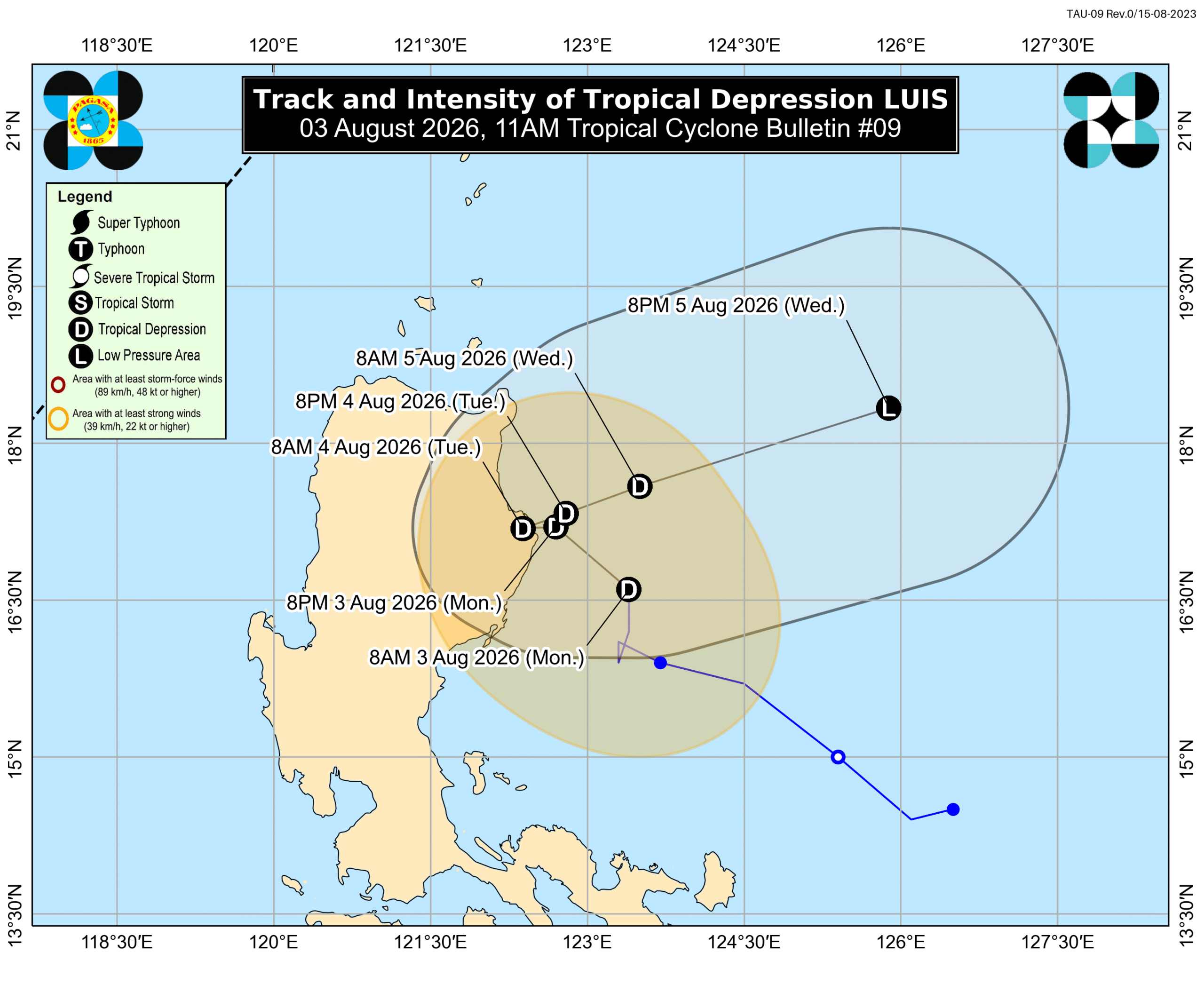
Tropical Depression Luis slightly weakened off Isabela on Monday morning, August 3, but it is still bringing significant rainfall to Luzon, especially several provinces in Northern Luzon and Central Luzon. Luis’ maximum sustained winds decreased from 55 kilometers per hour to 45 km/h, said the Philippine Atmospheric, Geophysical, and Astronomical Services Administration (PAGASA) in a bulletin issued at 11 am on Monday. The tropical depression’s gustiness eased from 70 km/h to 55 km/h. As of 10 am, it was located 165 kilometers east of Echague, Isabela, moving north at 15 km/h. Luis remains on track to make landfall in or pass close to Northern Luzon on Monday evening or early Tuesday morning, August 4. "Afterwards, it will sharply turn east northeastward while moving away from the Philippine landmass," PAGASA said, although it added that the tropical depression’s forecast track remains “highly uncertain” and can still change. Based on PAGASA’s updated rainfall advisory released at 11 am on Monday, Pangasinan now faces intense to torrential rain from Luis in the next 24 hours. Monday noon, August 3, to Tuesday noon, August 4: Intense to torrential rain (above 200 millimeters) in Pangasinan. Heavy to intense rain (100-200 mm) in La Union, Tarlac, Zambales, Bataan. Moderate to heavy rain (50-100 mm) in Ilocos Sur, Benguet, Ifugao, Mountain Province, Nueva Vizcaya, Quirino, Nueva Ecija, Aurora, Bulacan, Isabela, Pampanga, Metro Manila, Cavite, Batangas. Tuesday noon, August 4, to Wednesday noon, August 5: Heavy to intense rain (100-200 mm) in La Union, Pangasinan, Tarlac, Zambales, Bataan. Moderate to heavy rain (50-100 mm) in Ilocos Sur, Benguet, Nueva Vizcaya, Aurora, Nueva Ecija, Bulacan, Pampanga, Metro Manila, Cavite, Batangas, Laguna, Rizal. The weather bureau advised all areas affected by the tropical depression to watch out for floods and landslides. The southwest monsoon or habagat will also start bringing significant rainfall on Tuesday, initially to Occidental Mindoro and Antique, before heavily affecting portions of Central Luzon and Calabarzon. Floods and landslides are likely, too. Wednesday noon, August 5, to Thursday noon, August 6: Moderate to heavy rain (50-100 mm) in Zambales, Bataan, Cavite, Batangas, Occidental Mindoro, Antique. The southwest monsoon will be enhanced by the tropical cyclone with the international name Dolphin, which is currently a typhoon outside the Philippine Area of Responsibility (PAR). The typhoon was located 2,735 kilometers east northeast of extreme Northern Luzon as of 10 am on Monday, moving west northwest at 20 km/h. It still has maximum sustained winds of 155 km/h and gustiness of up to 190 km/h. PAGASA is not ruling out the possibility of Dolphin entering PAR. The typhoon may just stay near the PAR northern boundary, but it is expected to enhance the southwest monsoon. Luis is the Philippines’ 12th tropical cyclone for 2026, and the first for August. PAGASA earlier said two to four tropical cyclones could develop within or enter PAR during the month. – Rappler.com

0

Original source

Rappler Philippines

原文を読む