Storm Maysak Approaches Vietnam's Northern Coast, Threatening Ha Long Bay Area
Storm Maysak is approaching Vietnam's northern coast, posing a potential threat to the Ha Long Bay region. Strong winds and heavy rainfall are expected over the weekend, raising concerns about damage to coastal infrastructure.
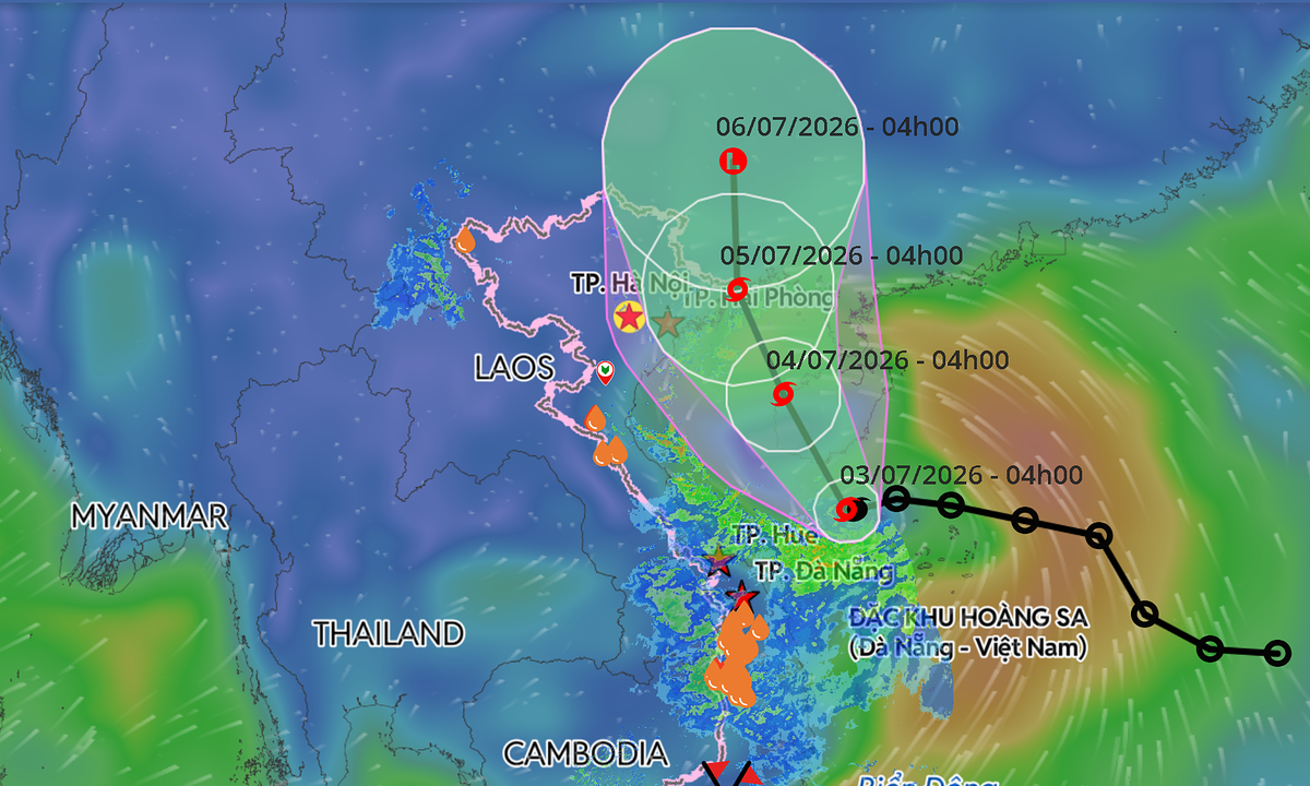
Storm Maysak has formed off Vietnam's coast and is expected to approach the northern region, potentially impacting areas around Ha Long Bay. According to the National Center for Hydro-Meteorological Forecasting, the storm was located 110 km southeast of China's Hainan Island early Friday, with sustained winds of 74 kph and gusts up to 102 kph, moving northwest at 10-15 kph. Forecasters predict the storm will continue its north-northwest track over the next 24 hours, passing west of Hainan Island. By early Saturday, it is expected to be over the island's western region with little change in intensity. The storm is forecast to enter the Gulf of Tonkin by early Sunday before making landfall between Quang Ninh and Hai Phong, the provinces home to Ha Long Bay and other popular coastal attractions. It is then expected to move into China's Guangxi Province, weakening into a tropical depression by Monday. Meteorological agencies in Japan and Hong Kong also project the storm will maintain winds of around 65 kph over the Gulf of Tonkin, strengthening to approximately 72 kph as it nears the Vietnam-China border. Deteriorating weather conditions are anticipated across northern coastal waters. From Friday night, winds in the Gulf of Tonkin will increase to 39-61 kph, reaching 62-74 kph with gusts up to 102 kph near the storm's center. Wave heights are forecast at 2-4 meters, with coastal areas from Quang Ninh to Hung Yen experiencing waves of 2-3 meters. The weather agency has warned that strong winds, rough seas, and elevated water levels could pose a threat to ships, aquaculture facilities, sea dikes, and other coastal infrastructure. From Saturday afternoon, coastal localities from Quang Ninh to Hung Yen are expected to experience sustained winds of 39-49 kph, which could rise to 50-74 kph. Northeastern Vietnam may also be hit by thunderstorms, squalls, and wind gusts of up to 74 kph. Heavy rainfall is forecast from Friday night through Sunday across northeastern Vietnam and Thanh Hoa Province. Rainfall totals are expected to range from 100-200 mm, potentially increasing to 150-250 mm in parts of the northeast, with isolated areas likely to receive over 350 mm. The National Civil Defense Steering Committee has instructed coastal provinces from Quang Ninh to Khanh Hoa to closely monitor vessels at sea, warn them to avoid dangerous waters, and ensure the safety of residents and tourists in coastal and island areas. Rescue forces are on standby as authorities intensify monitoring and emergency preparedness. This year, only one tropical depression had formed in the East Sea before Maysak, and it did not pose a threat to Vietnam. Forecasters anticipate around five tropical storms and depressions will develop over the East Sea between June and August, close to the long-term average, with about two expected to directly affect Vietnam. Storm activity from September to December is forecast to be below average due to El Niño conditions. Despite the expected decline in storm numbers later this year, forecasters caution that localized torrential rain, flash floods, and landslides remain a significant threat, particularly in the mountainous regions of northern and central Vietnam. The East Sea recorded 21 tropical storms and depressions in 2025, the highest annual total since records began in 1961. Natural disasters that year resulted in 484 deaths or missing persons and economic losses exceeding VND104.7 trillion (US$4 billion), making it one of Vietnam's costliest years on record for disaster damage.
多角的分析
台風メーサークの接近は、ベトナム北部沿岸地域の経済活動に一時的な打撃を与える可能性がある。特に、観光業が盛んなハロン湾周辺では、観光客のキャンセルやインフラへの被害が懸念される。また、漁業や水産養殖業も荒天の影響を受け、生産活動が中断されるリスクがある。長期的には、インフラの復旧・強化にコストがかかる可能性があるが、ベトナム経済は近年、堅調な成長を続けており、短期的な影響は限定的であると考えられる。
投資家にとっては、短期的なインフラ被害や観光客減少による経済的損失が懸念材料となる。特に、沿岸部の観光関連企業や漁業関連企業への影響が注視される。しかし、ベトナムは依然として魅力的な投資先であり、今回の台風による影響は一時的なものと見なされる可能性が高い。むしろ、復旧・復興需要が新たな投資機会を生み出す可能性も否定できない。長期的な視点では、気候変動への適応策を講じている企業への投資が有利になるだろう。
台風メーサークの接近は、ベトナム北部沿岸地域の住民の生活に直接的な影響を与える。特に、低地の沿岸地域や島嶼部に居住する人々は、高潮や洪水、土砂災害のリスクに晒される。避難勧告やインフラへの被害は、日常生活の混乱を招く可能性がある。また、観光客の安全確保も重要な課題となる。過去の自然災害の経験から、ベトナム政府は迅速な対応と避難支援に努めるだろうが、被災地の復旧には時間と労力がかかる。
沿岸部の住民、特に漁業や観光業に携わる人々は、台風の接近により直接的な生計への影響を心配している。ハロン湾周辺の事業者にとっては、観光シーズン中の悪天候は大きな痛手となる。また、強風や大雨による住居への被害、インフラの寸断も懸念される。政府による避難勧告や支援策が、住民の不安を和らげる鍵となるだろう。
背景・歴史的文脈
ベトナムは、東南アジアの沿岸国として、熱帯低気圧の影響を受けやすい地理的条件にある。特に、東シナ海(ベトナムでは南シナ海と呼称)は、台風の発生源の一つであり、毎年複数の台風がベトナム沿岸に接近・上陸している。過去には、2025年に記録的な数の台風が襲来し、甚大な被害をもたらした事例もある。これらの自然災害は、ベトナムの経済発展や社会インフラに継続的な課題を突きつけており、気候変動への適応策と防災対策の強化が喫緊の課題となっている。
原文ソース
VnExpress International