Magnitude 4.9 Aftershock Jolts Davao Occidental
A magnitude 4.9 earthquake struck near Balut Island in Davao Occidental, Philippines, as an aftershock to major quakes on June 8. The tremor has caused concern among residents in the affected region.
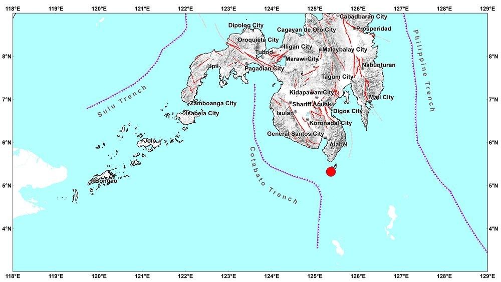
MANILA, Philippines — A magnitude 4.9 quake occurred in Balut Island in Sarangani, Davao Occidental at around 5:34 a.m on Wednesday, July 1, according to the country’s earthquake monitoring agency. The Philippine Institute of Volcanology and Seismology (Phivolcs) said the recorded earthquake was an aftershock of the magnitude 7.8 and magnitude 6.5 earthquakes that struck offshore Sarangani and offshore Davao Occidental respectively on June 8. The following reported intensities were felt in the following areas: Instrumental facilities, meanwhile, were recorded in these areas: Reported intensities are earthquake intensities assessed subjectively based on human observation and structural damages, while instrumental intensities are measured objectively using seismological instruments. Intensity refers to the strength of the ground shaking, while magnitude is the amount of energy and size of the earthquake.
多角的分析
今回の地震は直接的な経済的影響は限定的と考えられるが、継続的な地震活動はインフラ投資や観光業への潜在的なリスクとなる。特に、インフラの脆弱性が指摘される地域では、復旧・復興コストの増大が懸念される。
フィリピンにおける地震リスクは、不動産やインフラ関連企業への投資判断において重要な要素となる。保険市場の動向や、耐震基準の強化に向けた政府の取り組みが、投資家のリスク評価に影響を与えるだろう。
マグニチュード4.9の余震であっても、過去の大地震の記憶が残る住民にとっては、心理的な不安を増大させる。特に、建物の被害や避難生活を経験した人々にとっては、些細な揺れでも緊張感が高まる。ダバオ・オクシデンタル州のバルト島周辺のコミュニティでは、住民間の情報共有や避難体制の確認が重要となる。
過去の大きな地震の経験から、住民は余震に対する警戒を強めている。特に、建物の安全性や避難場所へのアクセスが懸念される。地方自治体による迅速な情報提供と、住民一人ひとりの防災意識の向上が求められている。
背景・歴史的文脈
フィリピンは、太平洋プレートとユーラシアプレートの境界に位置し、環太平洋火山帯の一部であるため、地震活動が非常に活発な地域である。特に、フィリピン断層帯やマニラ海溝などが主要な地震発生源となっている。過去には、1976年のミンダナオ島沖地震(マグニチュード7.9)や2013年のボホール島地震(マグニチュード7.2)など、甚大な被害をもたらす地震が頻発している。これらの地震は、津波や地滑りといった二次災害も引き起こすため、常に警戒が必要とされている。
原文ソース
Philstar Nation