Tropical Storm Kiyapo Batters Northern Philippines with Strong Winds, Heavy Rains
Environment
2026年7月24日
3
Inquirer NewsInfo

General articles are free for 24 hours after publish.

Tropical Storm Kiyapo Batters Northern Philippines with Strong Winds, Heavy Rains

Share
AI Summary

Tropical Storm Kiyapo has intensified, prompting wind signal advisories over Northern Luzon. It is expected to enhance the southwest monsoon over the weekend, affecting a wider area.

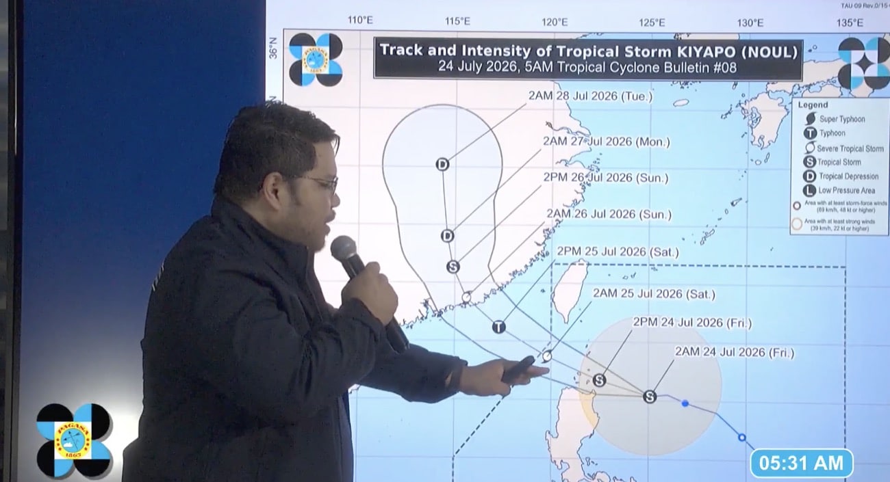
MANILA, Philippines — Wind signal advisories were hoisted over parts of Northern Luzon on Friday, July 24, as Kiyapo, formerly a tropical depression, intensified into a tropical storm, the state weather bureau reported. Philippine Atmospheric, Geophysical and Astronomical Services Administration (Pagasa) weather specialist Obet Badrina said during a 5 a.m. weather advisory that Wind Signal No. 2 was raised over Batanes, northern portion of Mainland Cagayan, including Babuyan Islands, and the northern portion of Ilocos Norte, due to Kiyapo. Meanwhile, Wind Signal No. 1 was placed over the following areas: READ: Kiyapo to make possible landfall in Babuyan Islands on Friday He added that Kiyapo may intensify into a severe tropical storm before it exits the Philippine area of responsibility on Saturday morning, which means chances of Wind Signal No. 3 being raised is still high. “So, before it exits the Philippine Area of Responsibility early tomorrow morning, it could intensify into a severe tropical storm; this means the Tropical Cyclone Wind Signal raised could go up to Signal No. 3,” Badrina said. As of 4 a.m., the center of Kiyapo was estimated 345 kilometers east of Aparri, Cagayan, moving west northwestward at 30 kilometers per hour. It packs maximum sustained winds of 65 kilometers per hour near the center and gustiness of up to 80 kilometers per hour. According to Badrina, Kiyapo is likely to closely approach or make landfall over Babuyan Islands during its passage. “The storm’s center could pass within the cone of probability, meaning it may make landfall on any of the islands in the Babuyan Islands. It could also pass close to the islands without making landfall,” Badrina stated. Despite exiting on Saturday, Kiyapo may still enhance the southwest monsoon, or habagat, affecting the western sections of Northern and Southern Luzon, Badrina said. READ: Kiyapo putting 6,947 barangays at risk of landslides, floods — OCD “Even though Kiyapo is already outside the Philippine area of responsibility, it will continue to intensify the southwest monsoon. Consequently, cloudy skies are likely to persist over large parts of Luzon through the weekend, even after the typhoon exits tomorrow — particularly in the western sections of Northern and Southern Luzon,” he added. Strong to gale-force winds brought by Kiyapo are affecting the northern seaboard of Northern Luzon, particularly Batanes and Babuyan Islands, causing rough to very rough sea conditions of up to 3.1 meters to 5.5 meters wave height, according to Pagasa. Rough sea conditions of up to 2.8 meters to 5 meters wave height may be also experienced in the northern seaboards of Cagayan and Ilocos Norte due to the tropical storm. Meanwhile, the southwest monsoon may affect Mindanao and the western sections of Southern Luzon and Visayas, bringing occasional rains over Occidental Mindoro, Palawan, Antique, Iloilo, Guimaras, and Negros Occidental on Friday. Cloudy skies with scattered rains and thunderstorms may also prevail over the rest of the country due to the habagat, Badrina reported. “The expanse of the cloud is affecting Northern Luzon as the southwest monsoon, or habagat, continues to have an impact. That’s why a large part of the country is being affected by cloud cover from the typhoon and the habagat,” he said. /das

0

Original source

Inquirer NewsInfo

原文を読む