Super Typhoon Bavi Enters PAR, Prompts Storm Signal No. 1 in Luzon
Environment
2026年7月9日
3
BusinessWorld Nation

Super Typhoon Bavi Enters PAR, Prompts Storm Signal No. 1 in Luzon

AI サマリー

Super Typhoon Bavi has entered the Philippine Area of Responsibility (PAR), prompting the hoisting of Storm Wind Signal No. 1 in several areas of Luzon. While direct impacts are currently limited, the typhoon is expected to enhance the southwest monsoon by the weekend.

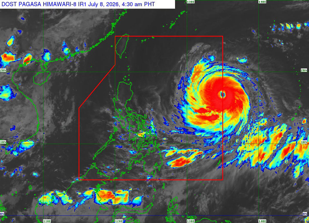
Super Typhoon Bavi (international name), which has been monitored since last week, has entered the Philippine Area of Responsibility (PAR), prompting the hoisting of Storm Wind Signal No. 1 in several areas in Luzon, according to the state weather bureau on Wednesday. Bavi entered the PAR at around 3 a.m. and was formally assigned the local name Inday, the Philippine Atmospheric, Geophysical and Astronomical Services Administration (PAGASA) said in its 5:00 a.m. briefing. The super typhoon was last located 1,405 kilometers east of Northern Luzon. It retained its strength, packing maximum sustained winds of 185 kilometers per hour (kph) and gusts of up to 230 kph. It is moving westward at 25 kph. Following its entry, Storm Signal No. 1 has been hoisted over several areas in Luzon. This includes areas such as Batanes; Cagayan, including the Babuyan Islands; Apayao; and the northern and central portions of Isabela, including Santo Tomas, Aurora, Santa Maria, Quezon, San Mariano, Naguilian, Dinapigue, Roxas, Luna, Delfin Albano, Cauayan City, San Pablo, Ilagan City, Benito Soliven, Tumauini, Cabagan, Reina Mercedes, San Manuel, Palanan, Cabatuan, Quirino, Divilacan, Gamu, Mallig, Maconacon, Burgos, San Guillermo, Angadanan, Alicia, and San Mateo. It is likewise in effect in the eastern portion of Kalinga, including Pinukpuk, Tabuk City, and Rizal; Dilasag in Aurora; and the northern and central portions of Catanduanes, including Pandan, Caramoran, Bagamanoc, Panganiban, Viga, Gigmoto, Baras, and San Miguel. PAGASA said that under Signal No. 1, minimal to minor threats to life and property due to strong winds are possible within the next 36 hours. The bureau also emphasized that the super typhoon has yet to directly affect the country during the forecast period. The heavy rains that drenched Metro Manila and nearby areas early Wednesday were caused by localized thunderstorms. “The heavy rains that we experienced in Metro Manila and nearby areas were not caused by the super typhoon… and southwest monsoon,” Chenel Dominguez, PAGASA weather specialist, said during the briefing in Filipino. “Based on satellite images, the storm is too far from Metro Manila,” she added. However, the super typhoon is expected to enhance the southwest monsoon by Friday, bringing scattered rains over large parts of the country, Ms. Dominguez said. “We remind the public to take caution and be prepared for rains that will be caused by the southwest monsoon,” she said. As for Bavi’s forecast track, it is expected to remain over the Philippine Sea and may be nearest to Extreme Northern Luzon by Friday. It is then forecast to exit the PAR by Saturday as it moves toward China. Bavi is expected to maintain its super typhoon strength until Thursday before weakening into a typhoon by Thursday afternoon or evening. — Edg Adrian A. Eva

多角的分析

経済的影響

台風バビのフィリピン空域(PAR)への進入は、直接的な被害は限定的と見られるものの、週末にかけて南西モンスーンを増強させることで、広範囲に影響を及ぼす可能性があります。これにより、農業や漁業への一時的な打撃、インフラへの潜在的なリスクが生じます。特に、農作物の被害は食料供給と物価に影響を与える可能性があり、経済活動への間接的な影響も考慮する必要があります。過去の台風被害では、復旧に数週間から数ヶ月を要する場合もあり、経済への持続的な影響も無視できません。

投資家心理

超大型台風バビのPAR進入は、現時点では直接的な経済的損失のリスクは低いと見られます。しかし、週末にかけて南西モンスーンを増強させることによる広範囲の降雨は、インフラへの影響や、特に農業・漁業セクターへの一時的な生産性低下を引き起こす可能性があります。投資家としては、短期的な市場の変動よりも、長期的なインフラの強靭性や、気候変動による自然災害リスクへの適応策が取られているかどうかに注目する必要があります。BPO産業など、フィリピンの主要産業は通常、このような規模の台風に対してある程度の耐性を持っていますが、サプライチェーンへの影響は注視すべきです。

社会的影響

台風バビの進入は、ルソン島北部の一部地域に暴風警報を発令しましたが、現時点では直接的な影響は限定的です。しかし、週末にかけて南西モンスーンの増強による降雨は、低地の浸水や土砂災害のリスクを高めます。特に、インフラが脆弱な地域や、農業・漁業に依存するコミュニティでは、生計への影響が懸念されます。過去の台風被害では、避難生活やインフラの損壊により、住民の日常生活が長期にわたり困難になる事例が数多く報告されています。PAGASAの注意喚起は、市民の安全確保に向けた重要な情報提供ですが、実際の被害軽減には地域社会の備えと行政の対応が不可欠です。

市民の声

台風バビがフィリピン空域に入ったというニュースは、特にルソン島北部沿岸の住民にとって、直接的な影響の有無に関わらず、不安材料となります。現時点では直接的な被害は予想されていませんが、週末にかけて南西モンスーンが強まることで、雨量が増え、浸水や土砂崩れのリスクが高まることは、日々の生活に影響を与えかねません。特に、交通網の寸断や、農作物への被害は、食料価格の上昇にもつながる可能性があり、家計を圧迫する懸念があります。過去の台風で被災した経験を持つ人々は、さらなる警戒を強めるでしょう。

背景・歴史的文脈

フィリピンは太平洋「火山の輪」に位置し、世界で最も台風の影響を受けやすい国の一つである。年間平均20個以上の台風がフィリピン空域(PAR)に進入し、そのうち数個が甚大な被害をもたらす。特に、2013年の台風ヨランダ(ハイエン)は、甚大な被害と多数の死者を出し、フィリピンの防災・減災対策の脆弱性を浮き彫りにした。これ以降、政府は防災インフラへの投資や早期警報システムの強化を進めているが、依然として自然災害への対応は喫緊の課題である。

原文ソース

BusinessWorld Nation

原文を読む