Ho Chi Minh City's Transformation: From Swamps to Skyscrapers in 50 Years
Ho Chi Minh City has undergone a dramatic transformation over the past half-century, evolving from a landscape of swamps to a modern metropolis of skyscrapers. Key infrastructure developments have driven this change, symbolizing economic growth and urban expansion.
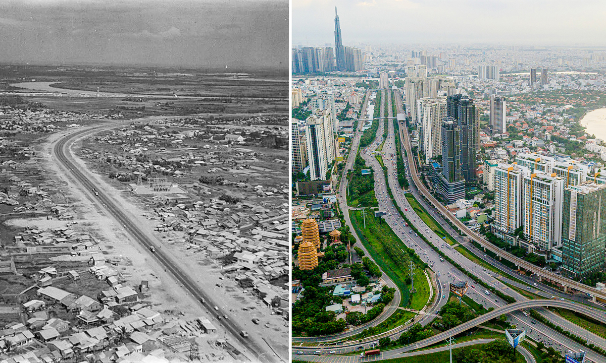
Ho Chi Minh City has undergone a remarkable transformation over the past half-century, evolving from a landscape of swamps into a modern metropolis dominated by skyscrapers. This urban development has been significantly propelled by major infrastructure projects. A prime example is the Phu My Bridge, spanning the Saigon River and connecting District 7 with Thu Duc City. Opened in 2009 after four years of construction, this cable-stayed bridge is over 2 km long and boasts a clearance of 45 meters, the highest of any bridge in the city. It features six lanes, a width of 27.5 meters, a main span of 350 meters, and towers reaching 160.5 meters in height. Built under a BOT contract, its total investment was nearly VND2.1 trillion ($80 million). The bridge links Nguyen Van Linh and Vo Chi Cong streets, facilitating traffic to and from Cat Lai and Phu Huu ports, and handles nearly 30,000 vehicles daily, predominantly heavy trucks. Another crucial artery is the Pham Van Dong Boulevard, inaugurated in 2013 after five years of construction. This 14-km, 12-lane road, with a total cost of nearly $495 million, is one of the most attractive inner-city routes. As a radial route, it connects Tan Son Nhat Airport with National Highways 13, 1, and 1K, with the 1.1-km Binh Loi Bridge and its Nielsen arch serving as a centerpiece. The boulevard has been instrumental in reducing congestion, enhancing the urban landscape, and spurring development at the city's northeastern gateway. These large-scale infrastructure projects have played a pivotal role in accelerating Ho Chi Minh City's economic growth and urbanization. As the city transforms from its swampy origins into a modern international business hub, infrastructure development remains an indispensable foundation.
多角的分析
ホーチミン市のインフラ整備は、単なる交通網の拡充に留まらず、経済活動の効率化と地域経済の活性化に直結している。フーミー橋やファム・ヴァン・ドン大通りは、物流コストの削減、港湾機能の強化、そして周辺地域への投資誘致を促進する。特に、ベトナム経済が製造業と輸出に依存する中で、これらのインフラはサプライチェーンのボトルネック解消に不可欠であり、国際競争力を高める要因となっている。BOT方式の採用は、民間資本の活用により、政府の財政負担を軽減しつつ、迅速なプロジェクト遂行を可能にした。これは、ベトナムが経済成長を維持・加速させる上で、インフラ投資をどのように戦略的に進めているかを示す好例である。
ホーチミン市のインフラ投資は、国内外の投資家にとって、都市の成長ポテンシャルを示す重要なシグナルとなる。フーミー橋やファム・ヴァン・ドン大通りといった大規模プロジェクトは、都市の接続性向上、物流効率の改善、そして不動産開発の潜在力拡大を示唆する。これにより、製造業、物流業、不動産業への投資が促進されると考えられる。BOT方式によるインフラ建設は、民間セクターの参画を促し、投資リスクの分散と収益機会の創出につながる。投資家は、これらのインフラがもたらす経済効果を評価し、将来の都市開発や経済成長を見据えた投資判断を行う。
インフラ整備は、ホーチミン市民の生活の質向上に直接的な影響を与える。ファム・ヴァン・ドン大通りの整備は、タンソンニャット空港へのアクセスを改善し、通勤時間を短縮することで、多くの市民の日常生活の負担を軽減した。また、交通渋滞の緩和は、大気汚染の低減にも寄与し、都市環境の改善につながる。一方で、大規模開発は、土地利用の変化や、それに伴う地域住民の移転、生活様式の変化といった課題も生じさせる可能性がある。開発の恩恵が、都市住民全体に公平に分配されるかどうかが、社会的な持続可能性の観点から問われる。
ホーチミン市のインフラ整備は、市民の生活に大きな変化をもたらしている。かつては湿地帯だった地域が、近代的な道路や橋によって結ばれ、移動が格段に便利になった。特に、ファム・ヴァン・ドン大通りの開通は、タンソンニャット空港へのアクセスを改善し、多くの市民の通勤時間を短縮した。フーミー橋は、サイゴン川を挟んだ地域間の往来を容易にし、物流の円滑化を通じて経済活動にも貢献している。しかし、都市開発の進展に伴い、地価の高騰や生活コストの上昇も無視できない課題であり、開発の恩恵が一部の層に偏らないような配慮が求められている。
背景・歴史的文脈
ホーチミン市、旧サイゴンは、ベトナム戦争終結後、経済的困難に直面していた。1975年以降、都市は復興と再建の道を歩み始めたが、インフラは老朽化し、交通渋滞は深刻な問題だった。1986年のドイモイ(刷新)政策導入以降、市場経済化が進み、外国からの投資が流入し始めた。これに伴い、都市開発とインフラ整備の必要性が高まり、特に2000年代以降、大規模な橋梁や道路建設が加速した。フーミー橋やファム・ヴァン・ドン大通りの建設は、この時期の都市開発戦略の中心的なプロジェクトであり、ベトナムの一党体制下での経済成長と都市化を象徴する出来事である。
原文ソース
VnExpress International