Super Typhoon Bavi Remains Outside PAR, Fair Weather Expected Over Weekend
Most of the Philippines is expected to experience generally fair weather over the weekend as Super Typhoon Bavi stays outside the country's area of responsibility (PAR). However, the typhoon's approach may enhance the southwest monsoon, potentially bringing rain to some areas later in the week.
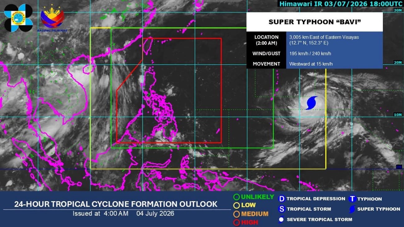
MANILA, Philippines — Most parts of the country will experience generally fair weather on Saturday as Super Typhoon Bavi remains outside the Philippine area of responsibility (PAR), the state weather bureau said. According to the Philippine Atmospheric, Geophysical and Astronomical Services Administration (Pagasa), the cyclone was last spotted 2,985 km east of Eastern Visayas as of 3 a.m. Saturday, packing maximum sustained winds of 195 kilometers per hour (kph) and gusts of up to 240 kph while moving westward at a speed of 15 kph. Pagasa weather specialist Veronica Torres said it has no direct effects on any part of the country as of now. READ: Another storm headed for PH, but Angat Dam water still low “However, as the typhoon moves closer to the country, it may also enhance the southwest monsoon, or habagat, which could affect parts of the Philippines in the coming days,” Torres said in Pagasa’s latest weather briefing. Meanwhile, the easterlies, or warm winds coming from the Pacific Ocean, are affecting the eastern sections of Luzon and Visayas. As a result, Cagayan Valley, Bicol Region, Eastern Visayas, Aurora, Quezon, and Dinagat Islands will have partly cloudy to cloudy skies with isolated rain showers or thunderstorms. “Metro Manila and the rest of Luzon will continue to experience fair weather, although thunderstorms remain possible, especially in the afternoon and evening,” Torres added. READ: Typhoon outside PH may enter PAR by Wednesday — Pagasa Pagasa said the same condition is expected to continue until Tuesday. Moreover, the habagat may begin affecting parts of the country by Wednesday, bringing rains over Mimaropa and the western sections of Visayas and Mindanao. /das
多角的分析
現時点では台風の直接的な経済的影響は限定的だが、南西モンスーンの強化による雨は、農作物に被害をもたらし、特に地方経済に打撃を与える可能性がある。過去の事例では、モンスーンによる洪水や土砂災害がインフラに損害を与え、復旧に多額の費用がかかることが確認されている。
短期的な投資環境への影響は少ないが、長期的に見れば、気候変動による異常気象の頻度増加は、農業、漁業、インフラ関連セクターへのリスク要因となる。投資家は、自然災害への耐性を持つ企業や、災害復旧・インフラ整備関連の事業機会を注視する必要がある。
週末の晴天は、屋外活動や観光業にとって一時的な恩恵となる。しかし、南西モンスーンの強化による雨は、特に低地やインフラの脆弱な地域における交通の混乱、住居への浸水被害、そして感染症のリスクを高める可能性がある。ディナガット諸島のような沿岸地域では、住民の不安が増大する。
週末は比較的穏やかな天候が予想されるため、多くの市民は屋外での活動を楽しむことができるだろう。しかし、Pagasaの予報通り、週後半にかけて南西モンスーンが強まると、マニラ首都圏を含む一部地域では、午後の雷雨や、場合によっては局地的な洪水に注意が必要となる。これは、通勤・通学や日常の移動に影響を与える可能性がある。
背景・歴史的文脈
フィリピンは太平洋の「火山の輪」に位置し、台風銀座とも呼ばれる地域に属する。毎年平均20個以上の台風がフィリピンに接近または上陸し、特に9月から11月にかけての時期は、大型台風の襲来リスクが高まる。過去には、2013年の台風ハイエン(ヨランダ)のように、甚大な被害をもたらした事例もあり、国民生活や経済に深刻な影響を与えてきた。そのため、気象庁による早期警戒と、政府・自治体による防災対策、そして国際社会からの支援が、被害軽減のために不可欠となっている。
原文ソース
Inquirer NewsInfo