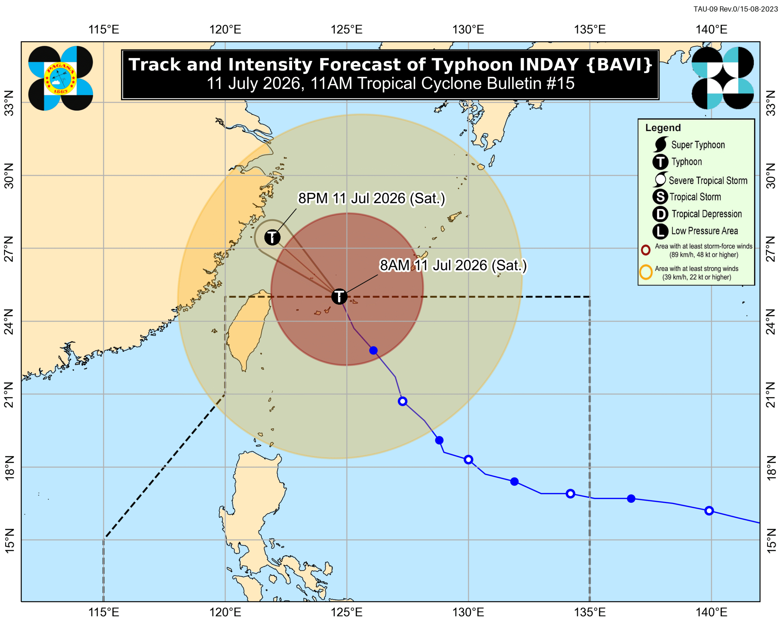
Typhoon Inday exits PAR but enhances monsoon, bringing heavy rains to parts of Philippines
Typhoon Inday has exited the Philippine Area of Responsibility (PAR) but continues to enhance the southwest monsoon, bringing heavy rains and strong winds to various parts of the Philippines. Alert is particularly advised for parts of Luzon and the Visayas.
Typhoon Inday (Bavi) exited the Philippine Area of Responsibility (PAR) at 8:20 am on Saturday, July 11, but its outer bands are still bringing strong winds and it continues to enhance the southwest monsoon or habagat, according to the Philippine Atmospheric, Geophysical, and Astronomical Services Administration (PAGASA). As of 10 am, Inday was already 590 kilometers north northeast of Itbayat, Batanes, moving north northwest at 20 kilometers per hour (km/h). The typhoon has maximum sustained winds of 140 km/h and gustiness of up to 170 km/h, according to the 11 am bulletin of PAGASA. At its peak, Inday was a super typhoon. Inside PAR, its highest maximum sustained winds reached 195 km/h. Inday is no longer expected to trigger significant rainfall in Batanes after its exit from PAR, but the province remains under Signal No. 1 as of 11 am on Saturday due to strong winds. Signal No. 2 was the highest tropical cyclone wind signal raised due to Inday, which did not make landfall in the Philippines but still affected parts of Luzon due to its size and intensity. The enhanced southwest monsoon and the periphery or outer bands of the typhoon are also bringing strong to gale-force gusts to these areas: Saturday, July 11 most of the country Sunday, July 12 most of Luzon, most of Visayas, Zamboanga del Norte, Misamis Occidental, Lanao del Norte, Camiguin, Davao Oriental Monday, July 13 most of Luzon, Western Visayas, Negros Occidental Aside from winds, PAGASA warned the public that significant rain from the southwest monsoon may persist in the next three days. Affected areas must stay on alert for floods and landslides. Saturday noon, July 11, to Sunday noon, July 12 Heavy to intense rain (100-200 millimeters): Zambales, Bataan, Occidental Mindoro Moderate to heavy rain (50-100 mm): La Union, Pangasinan, Benguet, Tarlac, Pampanga, Bulacan, Metro Manila, Rizal, Cavite, Laguna, Batangas, Oriental Mindoro, Romblon, Marinduque, Palawan, Antique, Aklan, Capiz, Iloilo, Guimaras, Negros Occidental Sunday noon, July 12, to Monday noon, July 13 Heavy to intense rain (100-200 mm): Zambales, Bataan, Occidental Mindoro Moderate to heavy rain (50-100 mm): Ilocos Norte, Ilocos Sur, Abra, La Union, Pangasinan, Benguet, Tarlac, Pampanga, Bulacan, Metro Manila, Rizal, Cavite, Batangas, Oriental Mindoro, Romblon, Palawan, Antique, Aklan Monday noon, July 13, to Tuesday noon, July 14 Heavy to intense rain (100-200 mm): Zambales Moderate to heavy rain (50-100 mm): Ilocos Norte, Ilocos Sur, Abra, La Union, Pangasinan, Benguet, Tarlac, Bataan, Pampanga, Occidental Mindoro In addition, coastal warnings remain in effect on Saturday. Up to very rough to high seas (travel is risky for all vessels) Northern seaboard of Batanes – waves up to 7 meters high Remaining seaboards of Batanes – waves up to 6 meters high Northern seaboard of Babuyan Islands – waves up to 5 meters high Northern seaboard of mainland Cagayan; remaining seaboards of Babuyan Islands – waves up to 4.5 meters high Up to rough seas (small vessels should not venture out to sea) Seaboard of Isabela; northern seaboard of Ilocos Norte; remaining seaboard of mainland Cagayan – waves up to 4 meters high Seaboard of northern Aurora; northern and eastern seaboards of Catanduanes – waves up to 3.5 meters high Seaboards of Ilocos Sur, Zambales, Kalayaan Islands, Camarines Norte, and Surigao del Sur; western seaboards of Pangasinan, Bataan, Occidental Mindoro including Lubang Islands, and Palawan including Calamian Islands; northern seaboard of Camarines Sur; northern and eastern seaboards of Northern Samar; eastern seaboards of Albay, Sorsogon, Eastern Samar, Dinagat Islands, Siargao-Bucas Grande Islands; southern seaboards of Marinduque and Quezon; remaining seaboard of Ilocos Norte – waves up to 3 meters high Up to moderate to rough seas (small vessels should take precautionary measures or avoid sailing, if possible) Seaboards of La Union, Cuyo Islands, Cagayancillo Islands, Romblon, and Antique; western seaboards of Cavite, Batangas, Burias Islands, and Negros Occidental; southern and eastern seaboards of Oriental Mindoro; southern seaboards of Iloilo and Guimaras; eastern seaboard of Davao Oriental; remaining seaboards of Aurora and Quezon – waves up to 2.5 meters high Seaboards of Zamboanga del Norte, Misamis Oriental, Camiguin, and Davao Occidental; southern seaboards of Negros Oriental, Siquijor, Bohol, and Davao Oriental; western and southern seaboards of Masbate; eastern seaboard of northern Palawan including Calamian Islands; remaining seaboards of Pangasinan, Iloilo, and Guimaras – waves up to 2 meters high Outside PAR, Inday will head for the East China Sea and possibly make landfall in the eastern coast of mainland China on Saturday night or Sunday morning, July 12. PAGASA added that Inday is expected to remain a typhoon in the next 12 hours. It may weaken into a severe tropical storm over mainland China. Inday was the Philippines’ ninth tropical cyclone for 2026, and the second for July. The weather bureau earlier said two to four tropical cyclones may form within or enter PAR during the month. – Rappler.com
多角的分析
台風インディによる降雨強化は、農業セクターに影響を与える可能性がある。特に、雨量が多い地域では、作物の収穫やインフラへの損害が懸念される。一方で、水不足の地域では一時的な恵みとなる可能性もあるが、その影響は局地的であり、全体的な経済へのプラス効果は限定的と考えられる。
台風の接近や通過は、短期的な市場の不確実性を高める要因となる。特に、農業関連企業や、インフラの脆弱な地域に事業所を持つ企業は、サプライチェーンの混乱や操業停止のリスクに直面する可能性がある。投資家は、これらのリスクを考慮し、ポートフォリオのリスク分散を検討する必要がある。
台風インディによる南西モンスーンの強化は、フィリピン全土、特に低地の住宅地やインフラの脆弱な地域に住む人々に直接的な影響を与える。ザンバレス州やバターン州など、大雨が予想される地域では、洪水や土砂崩れの危険性が高まり、住民の避難や生活への支障が懸念される。また、荒れた海況は漁業従事者の生計を脅かす可能性がある。
台風インディによるモンスーン強化は、特にメトロ・マニラ首都圏の住民にとって、通勤・通学の困難さや、洪水の被害を増加させる。大雨による交通網の麻痺や、低地での浸水は、日常生活に大きな影響を与える。PAGASAからの最新情報に注意し、避難指示があれば速やかに従うことが重要だ。
背景・歴史的文脈
フィリピンは太平洋の「火山の輪」に位置し、台風銀座と呼ばれる地域に属するため、年間を通じて多くの熱帯低気圧の影響を受ける。特に7月は、南西モンスーンが活発化する時期であり、台風の接近と相まって、広範囲に大雨をもたらすことが多い。過去にも、台風による甚大な被害は繰り返されており、インフラの脆弱性や、都市部への人口集中が、被害を拡大させる要因となっている。政府は、防災計画の強化や、住民への早期警報システムの改善に努めているが、気候変動による異常気象の頻発化が、その効果を試している。
原文ソース
Rappler Philippines