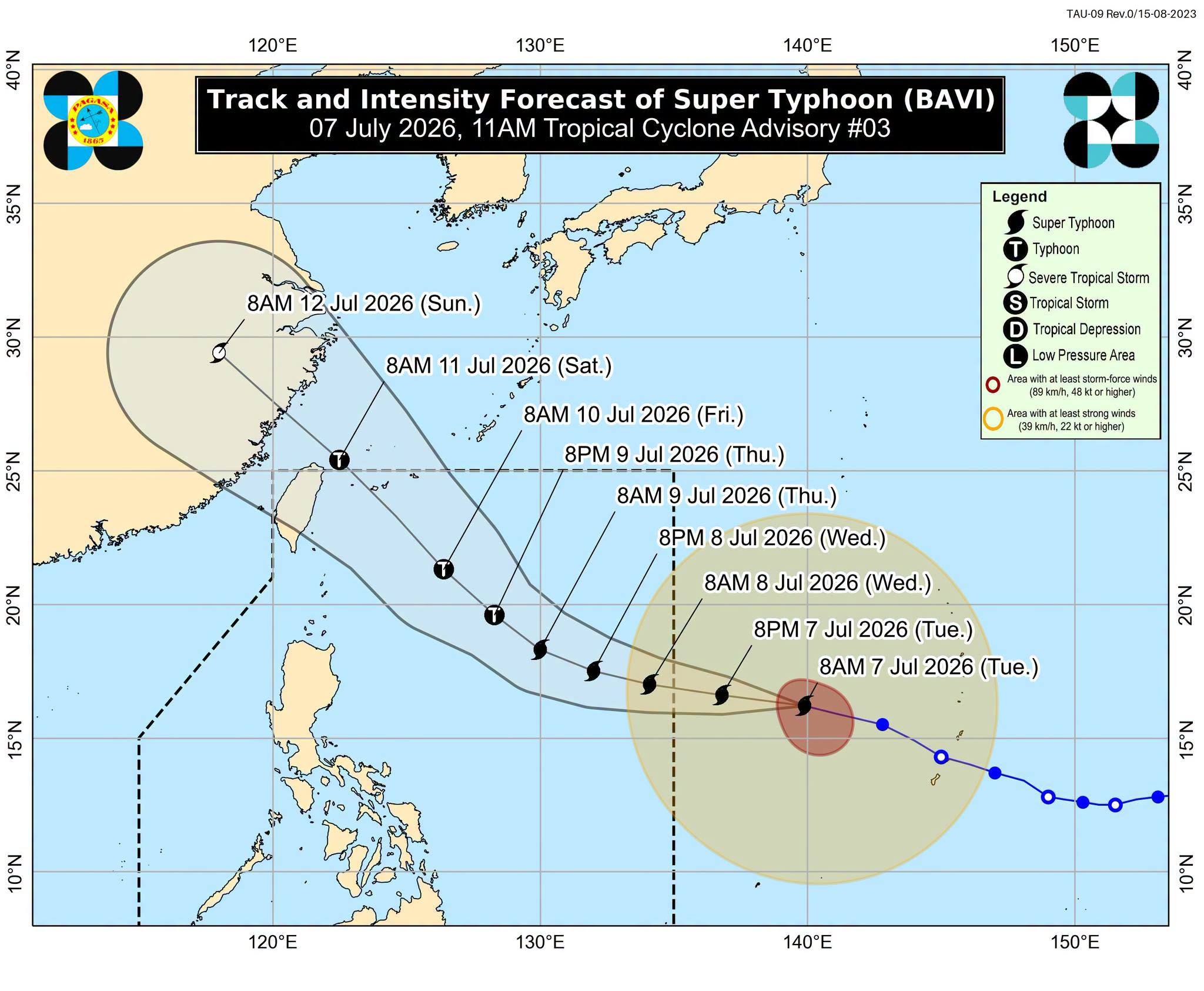
Super Typhoon Bavi Weakens Slightly Outside PAR, Remains Powerful
Super Typhoon Bavi has slightly weakened outside the Philippine Area of Responsibility (PAR) but remains a powerful tropical cyclone. While direct landfall in the Philippines is unlikely, it is expected to enhance the southwest monsoon, bringing heavy rains and strong winds to northern and eastern regions, prompting advisories.
Super Typhoon Bavi slightly weakened outside the Philippine Area of Responsibility (PAR) on Tuesday morning, July 7, but it remains a powerful tropical cyclone. As of 10 am on Tuesday, Bavi’s maximum sustained winds were down to 185 kilometers per hour (km/h), the minimum threshold for classification as a super typhoon by the Philippine Atmospheric, Geophysical, and Astronomical Services Administration (PAGASA). The super typhoon’s gustiness is currently up to 230 km/h. Bavi was last spotted 1,845 kilometers east of Central Luzon, moving west northwest at 20 km/h. It is still expected to enter PAR on Tuesday evening or early Wednesday morning, July 8. It will be given the local name Inday once it enters PAR. PAGASA said Bavi is likely to maintain its strength as a super typhoon as it enters PAR, but it may gradually weaken into a typhoon by Thursday, July 9, as it moves near extreme Northern Luzon and heads for Japan’s Ryukyu Islands. The chances of Bavi making landfall in the Philippines remain slim, but it will still affect parts of the country and enhance the southwest monsoon or habagat. PAGASA expects to raise tropical cyclone wind signals for the northern and eastern portions of Northern Luzon, possibly beginning Tuesday evening or Wednesday morning. "Due to the uncertainty in terms of radius of strong winds, the possibility of raising wind signals over the eastern portions of Southern Luzon and Visayas is not ruled out," added the weather bureau. The highest possible tropical cyclone wind signal could be Signal No. 2 or 3. The enhanced southwest monsoon and the periphery or outer bands of the super typhoon will also bring strong to gale-force gusts to the following areas: Tuesday, July 7 Most of Mindanao Wednesday, July 8 Pangasinan, Zambales, Bataan, Cavite, Batangas, most of Mimaropa, most of Bicol, most of Visayas, most of Mindanao Thursday, July 9 most of the country Meanwhile, PAGASA has issued a separate advisory for rainfall from the southwest monsoon, which may be heaviest in these areas beginning Wednesday: Wednesday noon, July 8, to Thursday noon, July 9 Moderate to heavy rain (50-100 millimeters): Antique, Negros Occidental, Sultan Kudarat, Sarangani Thursday noon, July 9, to Friday noon, July 10 Moderate to heavy rain (50-100 mm): Occidental Mindoro, Palawan, Antique, Guimaras, Iloilo, Negros Occidental, Lanao del Norte, Lanao del Sur In addition, PAGASA plans to issue a gale warning by Wednesday as it predicts rough to very rough sea conditions in the northern and eastern seaboards of the Philippines. Bavi or the future Inday would be the country’s ninth tropical cyclone for 2026, and the second for July. The weather bureau earlier said two to four tropical cyclones may form within or enter PAR during the month.
多角的分析
スーパー台風バビは、フィリピン経済に直接的な大きな被害をもたらす可能性は低いものの、その周辺地域への影響は無視できない。特に、南西モンスーンの強化による豪雨は、農業セクターに打撃を与える可能性がある。数百万人の生計が農業に依存しているフィリピンにおいて、収穫期の農作物への被害は食料価格の上昇やインフレ圧力につながりうる。また、インフラへの被害が軽微であっても、復旧作業や物流の遅延は短期的な経済活動の停滞を招く可能性がある。海外からの観光客への影響も懸念され、観光収入の減少につながることも考えられる。
投資家にとって、スーパー台風バビの直接的なフィリピン本土への上陸リスクが低いことは、短期的な市場の混乱を抑える要因となる。しかし、南西モンスーンの強化による農作物への被害懸念は、食料品関連企業や農業関連セクターへの投資リスクを高める可能性がある。また、インフラへの軽微な被害や物流の遅延は、サプライチェーンに依存する企業の業績に影響を与える可能性があり、注意が必要である。長期的には、気候変動による自然災害のリスク増加は、フィリピンにおけるインフラ投資や保険分野への影響を考慮する必要がある。
スーパー台風バビは、フィリピン本土への直接的な上陸リスクは低いものの、南西モンスーンを強化することにより、特に北部および東部地域に豪雨と強風をもたらす可能性がある。これにより、低所得者層や沿岸部に居住する人々、農業従事者への影響が懸念される。洪水や土砂災害のリスクが高まり、避難生活を余儀なくされる人々が出る可能性がある。また、強風によるインフラ被害は、電力供給の停止や交通網の寸断を引き起こし、日常生活に支障をきたす。PAGASAが発令する警報やアドバイザリーは、これらのリスクを軽減するための重要な情報源となるが、情報へのアクセスや避難体制の整備が、被害の最小化には不可欠である。
スーパー台風バビは、フィリピンに直接上陸しない可能性が高いものの、南西モンスーンを強めることで、特にルソン島北部や東部、そしてビサヤ諸島の一部地域に、水曜日から木曜日にかけて豪雨と強風をもたらす見込みです。これにより、これらの地域に住む人々、特に低地の住民や沿岸部の住民は、洪水や土砂災害の危険にさらされます。農作物を育てている人々は、収穫への影響を心配しています。また、強風は家屋やインフラに被害を与え、停電や交通の混乱を引き起こす可能性があります。PAGASAからの最新情報に注意し、安全な場所への避難や、食料・水の備蓄などの準備をすることが重要です。
背景・歴史的文脈
フィリピンは太平洋の「火山の輪」に位置し、熱帯低気圧の発生・進路に当たるため、年間を通して多くの台風に見舞われる。特に7月は台風シーズンであり、2つから4つの熱帯低気圧がフィリピン大気圏内(PAR)に入るか、またはその近辺で発生することが予測される。2026年も例外ではなく、バビ(国内名:インディ)は年内9番目の熱帯低気圧となる。過去にも、台風による甚大な被害はフィリピンの社会経済に深刻な影響を与えてきた。例えば、2013年のスーパー台風ヨランダ(ハイエン)は、数千人の死者を出し、広範囲に壊滅的な被害をもたらし、復興には長い年月を要した。気候変動の影響により、台風の強大化や頻度の変化が懸念されており、フィリピン政府は防災・減災対策の強化を迫られている。
原文ソース
Rappler Philippines