Super Typhoon Bavi to Enter PAR; Landfall Unlikely, Northern Luzon May Feel Winds
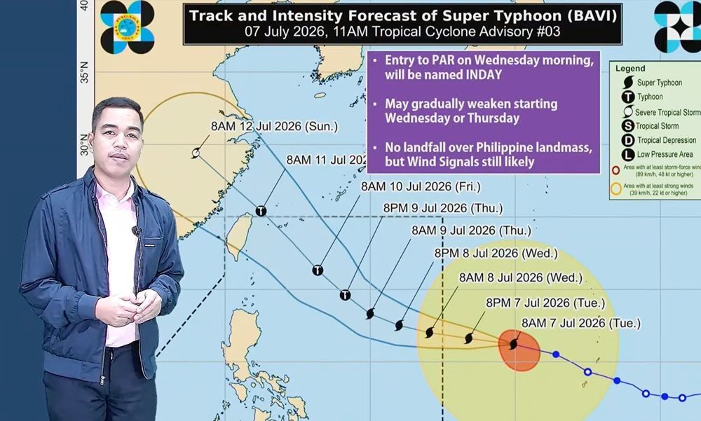
Super Typhoon Bavi is expected to enter the Philippine Area of Responsibility (PAR) early Wednesday. While landfall is unlikely, strong winds may affect northern areas like Batanes and Cagayan. The typhoon is also enhancing the southwest monsoon, potentially bringing heavy rains to western Mindanao.
Super Typhoon Bavi is expected to enter the Philippine Area of Responsibility (PAR) in the wee hours of Wednesday, July 8, while remaining unlikely to make landfall in the country. In its 5 p.m. advisory on Tuesday, July 7, state weather bureau PAGASA said Bavi was located more than 1,705 kilometers east of Central Luzon and continued moving west-northwestward at 25 kilometers per hour. Once it enters PAR, Bavi is expected to move over the northern portion of the Philippine Sea in a west-northwestward to northwestward direction from Wednesday to Friday. Bavi is expected to exit PAR on Saturday morning and move toward the northern part of Taiwan. “Kung pagbabasehan natin itong latest track at 'yung mga nagdaang track, maliit pa rin po ang tyansa na ito ay tatama sa ating kalupaan or magla-landfall,” weather specialist Benison Estareja said. (Based on our latest track and previous tracks, the chance of Bavi making landfall in the country remains low.) However, Bavi's 800-kilometer radius may bring strong winds to parts of Northern Luzon, particularly Batanes and the provinces of Cagayan, where Wind Signals No. 2 and 3 may be raised. PAGASA said it is also not ruling out the possibility of raising Wind Signal No. 1 in other areas of Northern Luzon, including Ilocos Norte, Apayao, Kalinga, Isabela and the northernmost part of Aurora. PAGASA said Bavi slightly strengthened as it continued approaching PAR, packing maximum sustained winds of 185 kilometers per hour (kph) near the center and gustiness of up to 230 kph. Bavi will be assigned the local name "Inday" once it enters PAR. “Base po sa latest animation ng PAGASA, wala namang direktang epekto itong si Bagyong Bavi sa alinmang panig ng ating bansa,” Estareja said. (Based on PAGASA's latest animation, Super Typhoon Bavi has no direct effects on any part of the country.) Bavi is also starting to enhance the habagat, or southwest monsoon, over the western section of Mindanao. PAGASA said this may bring a high chance of heavy rainfall over Zamboanga Peninsula, Bangsamoro Autonomous Region, SOCCSKSARGEN, Misamis Occidental and Lanao del Norte. “Kaya mag-ingat po sa minsang malalakas na ulan na posible magdulat ng flash floods or landslides,” Estareja said. (So be cautious of occasional heavy rains that may cause flash floods or landslides.) The rest of Luzon, Visayas and western Mindanao may also experience moderately strong winds and occasional rains over the next few days due to the enhanced habagat once Bavi enters PAR. Inday will be the second tropical cyclone to enter PAR in July and the ninth in 2026.
多角的分析
台風バビの接近は、直接的な被害が予想される地域においては、農作物への影響やインフラへの損害を通じて、地域経済に一時的な打撃を与える可能性がある。特に、漁業や農業に依存する地域では、強風や大雨による被害が懸念される。また、交通網の混乱や電力供給の停止なども、経済活動の停滞を招く要因となりうる。しかし、フィリピン全土への直接的な上陸が避けられる見込みであるため、経済全体への影響は限定的であると考えられる。むしろ、台風通過後の復旧活動や、インフラ整備への投資機会といった側面も考えられる。
現時点では、台風バビのフィリピンへの直接的な上陸が低いと予測されているため、投資家への直接的な短期リスクは限定的であると見られる。しかし、ルソン島北部への強風の影響や、ミンダナオ西部での大雨によるインフラ被害の可能性は、関連企業のサプライチェーンや事業継続性に一時的な影響を与える可能性がある。投資家は、これらの影響を受ける可能性のあるセクター(例えば、通信、電力、インフラ関連企業)の動向を注視する必要がある。長期的な視点では、気候変動への適応策や防災インフラへの投資が、より重要視されるようになるだろう。
台風バビの接近は、ルソン島北部沿岸地域に住む住民にとって、直接的な脅威となる可能性がある。強風や大雨による家屋の被害、インフラの寸断、そしてそれに伴う避難生活などが懸念される。また、ミンダナオ西部では、南西モンスーンの強化による大雨が、鉄砲水や地滑りのリスクを高める。これは、これらの地域に住む人々の生活基盤を脅かし、避難を余儀なくされる人々を生む可能性がある。PAGASAが注意を呼びかけているように、住民一人ひとりが最新の気象情報を確認し、安全確保のための対策を講じることが極めて重要となる。
台風バビの接近は、フィリピン国民、特にルソン島北部やミンダナオ西部の住民にとって、直接的な生活への影響をもたらす。ルソン島北部では、強風による家屋の損壊や停電、交通網の麻痺が予想される。ミンダナオ西部では、大雨による洪水や地滑りの危険性が高まり、避難が必要となるケースも考えられる。PAGASAは最新の気象情報を発信し、注意を促しているが、国民一人ひとりが防災意識を高め、個人の安全確保に努めることが求められている。海外で働くフィリピン人労働者(OFW)にとっても、故郷の家族の安全が懸念される事態である。
背景・歴史的文脈
フィリピンは、太平洋の「火山の輪」に位置し、台風銀座とも呼ばれる地域にあり、熱帯低気圧の通り道となっている。年間平均で約20個の熱帯低気圧がフィリピン大気圏(PAR)に入り、そのうち約8個が上陸する。特に7月から10月にかけては台風シーズンであり、大型の台風が頻繁に発生・接近する。過去には、2013年の台風ヨランダ(ハイエン)のように、甚大な被害をもたらした事例もあり、フィリピン国民にとって台風は常に身近な脅威である。気象庁(PAGASA)は、国民の生命と財産を守るため、台風情報の早期発表と注意喚起に努めている。
原文ソース
Philstar Nation