Cambodia Forecasts Thunderstorms and Gusts for Several Days, Urging Public Caution
The Ministry of Water Resources and Meteorology forecasts thunderstorms and gusts across approximately 45% of Cambodia from June 29 to July 1, with coastal areas particularly affected. Public caution is advised.
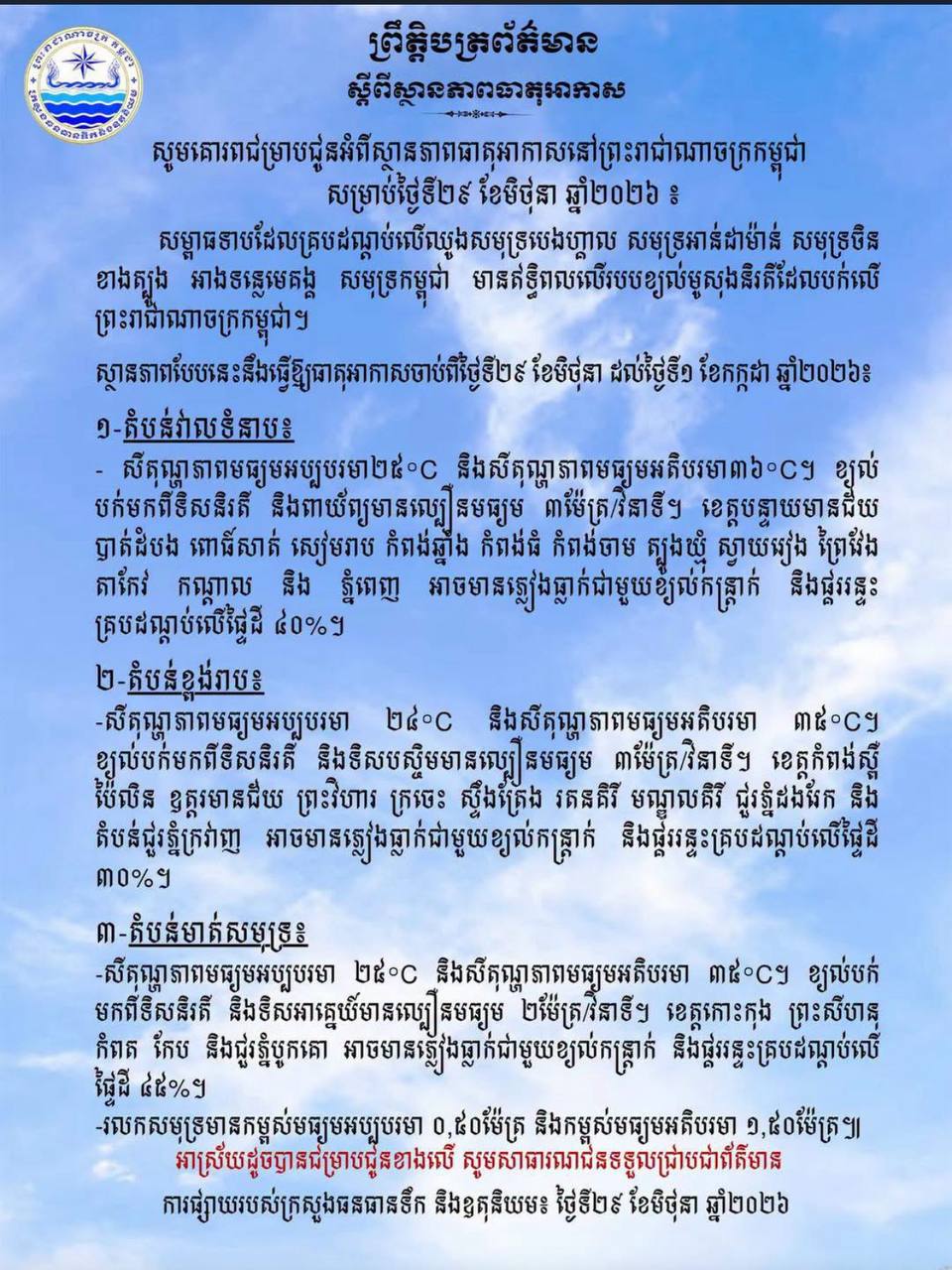
The Ministry of Water Resources and Meteorology has issued a notification to the public regarding weather conditions in the Kingdom of Cambodia from June 29 to July 1, 2026, forecasting potential thunderstorms and gusts across a significant portion of the country. According to the ministry, a low-pressure system covering the Bay of Bengal, Andaman Sea, South China Sea, and the Mekong River basin is influencing the weather patterns, leading to the southwest monsoon blowing over the Kingdom. This is expected to cause the following weather changes: In the plains, temperatures will range from a minimum of 25°C to a maximum of 36°C. Winds from the southwest and northwest will blow at an average speed of 3 meters per second. Areas including Banteay Meanchey, Battambang, Poipet, Siem Reap, Kampong Chhnang, Kampong Thom, Kampong Cham, Tboung Khmum, Svay Rieng, Prey Veng, Takeo, Kampot, and Phnom Penh may experience rain accompanied by gusts and thunderstorms, covering approximately 40% of these areas. In the highlands, the average minimum temperature will be 24°C and the average maximum temperature will be 35°C. Winds from the southwest and west will blow at an average speed of 3 meters per second. Provinces such as Kampong Speu, Pailin, Oddar Meanchey, Preah Vihear, Kratie, Stung Treng, Ratanakiri, Mondulkiri, and areas around the Dangrek Mountains and Cardamom Mountains may experience rain with gusts and thunderstorms, covering about 30% of these regions. Along the coast, the average minimum temperature will be 25°C and the average maximum temperature will be 35°C. Winds from the southwest and southeast will blow at an average speed of 2 meters per second. Provinces including Koh Kong, Preah Sihanouk, Kampot, Kep, and areas around Bokor Mountain may experience rain accompanied by gusts and thunderstorms, covering approximately 45% of these coastal areas. Sea waves are expected to range from a minimum average height of 0.50 meters to a maximum average height of 1.50 meters. The ministry urges the public to exercise caution and take necessary safety measures during this period.
多角的分析
この予報は、短期的ながらも農業や漁業、観光業に影響を与える可能性があります。特に沿岸部での漁業活動や、屋外での観光イベントは、一時的に中断または規模縮小を余儀なくされる可能性があります。インフラへの直接的な被害は限定的と見られますが、農業生産への影響は、降雨量や期間によっては無視できないレベルになることも考えられます。
投資家にとっては、短期的な天候変動は直接的な投資判断に大きな影響を与えにくいですが、インフラ関連や農業関連の短期的な操業リスクとして考慮される可能性があります。特に、沿岸部の観光リゾートや、季節的な農業生産に依存する事業では、一時的な収益減のリスクが考えられます。しかし、これは一時的な現象であり、長期的な投資環境に大きな変化をもたらすものではないと推測されます。
カンボジアの多くの地域、特に農村部では、人々の生活や生計が天候に大きく左右されます。今回の予報は、農作物の生育や収穫、漁業活動に直接的な影響を与える可能性があります。また、突風や雷雨は、脆弱な住居やインフラに被害をもたらすリスクも伴います。市民は、外出の計画を見直したり、農機具や家財の保護策を講じたりする必要に迫られるでしょう。特に、沿岸部では波浪の増加による漁船の安全確保が重要となります。
今回の気象予報は、カンボジア国民、特に農村部や沿岸部に住む人々の日常生活に直接的な影響を与えます。農作物の生育や収穫、漁業活動が中断される可能性があり、生計を立てる上で不安が生じます。また、突風や雷雨は、住居や公共施設に被害をもたらすリスクも伴います。市民は、外出や旅行の計画を慎重に立て、農機具や家屋の安全対策を講じる必要があります。沿岸部では、漁船の安全な停泊や、高波への警戒が不可欠となります。
背景・歴史的文脈
カンボジアは熱帯モンスーン気候に属し、年間の降雨パターンは南西モンスーンの影響を強く受けます。この時期(6月末から7月初旬)は、雨季の最中であり、しばしば雷雨や突風を伴う激しい気象現象が発生します。過去にも、同様の気象条件が農業生産やインフラに影響を与えた事例があります。特に、近年の気候変動の影響により、異常気象の頻度や強度が増加する傾向が指摘されており、水資源管理や防災対策の重要性が高まっています。
原文ソース
AKP Khmer