Typhoon Inday Weakens but Continues to Bring Rains Across Philippines
Environment
2026年7月9日
4
Inquirer NewsInfo

Typhoon Inday Weakens but Continues to Bring Rains Across Philippines

AI サマリー

Tropical cyclone Inday has weakened into a typhoon but continues to bring rains to major parts of the Philippines, according to the state weather bureau. Strong winds and rain bands are affecting several regions, with increased rainfall expected due to the enhanced southwest monsoon.

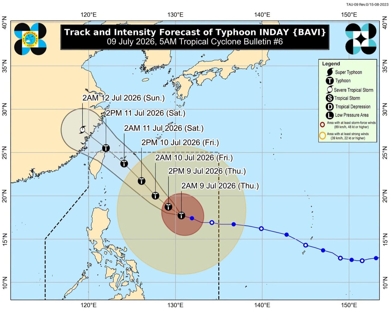
MANILA, Philippines — Tropical cyclone Inday, formerly Super Typhoon, weakens into a typhoon, but continues to bring rains over major parts of the country on Thursday, July 9, the state weather bureau said. Philippine Atmospheric, Geophysical and Astronomical Services Administration (Pagasa) weather specialist Leanne Loreto said during its 5 a.m. weather advisory that Inday, located 925 kilometers east of Northern Luzon, still maintains typhoon strength. “Although it (Inday) has weakened, the typhoon remains strong. As we can observe, many areas are still being affected by the wind fields and rain bands of Inday,” Loreto reported. Rains with gusty winds may prevail over Cagayan Valley, Cordillera Administrative Region, Ilocos Norte, Aurora, and Catanduanes due to the typhoon. READ: PCG suspends small vessel trips in northern Quezon due to Inday Inday is also forecast to affect Eastern Visayas and the rest of Bicol Region, bringing gloomy skies with scattered rains and thunderstorms. Meanwhile, the enhanced southwest monsoon, or habagat, is likely to bring cloudy skies with scattered rain showers over the following areas: The rest of Visayas and Mindanao are expected to experience partly cloudy to cloudy skies with occasional rains due to habagat. As of 4 a.m., Inday packs maximum sustained winds of 175 kilometers per hour near the center and gustiness of up to 215 kilometers per hour, moving west northwestward at 20 kilometers per hour. Tropical Cyclone Wind Signal No. 1 remains hoisted over parts of Luzon, including in: Meanwhile, strong to gale-force winds are affecting northern and eastern seaboards of Luzon, and the eastern seaboard of Visayas, according to Loreto. READ: Luzon provinces brace for Inday impact Inday is forecast to move northwestward while remaining over the Philippine Sea, and pass near extreme Northern Luzon by Friday evening, before exiting the country on Saturday, July 11. “Rainfall will intensify tomorrow due to the southwest monsoon. As the typhoon traverses the Philippine Sea, Inday will pull the monsoon winds toward Palawan and the Visayas,” Loreto said. /das

多角的分析

経済的影響

台風「インディ」による広範囲な降雨は、農業セクターに直接的な影響を与える可能性がある。特に、収穫期に近い地域では、作物の被害や収穫量の減少が懸念される。また、インフラへの被害が発生すれば、復旧コストが増大し、経済活動の停滞を招く恐れがある。フィリピン経済は依然として農業への依存度が高いため、こうした自然災害はマクロ経済にも影響を及ぼす可能性がある。

投資家心理

投資家にとって、台風によるインフラ被害や農業への影響は、インフラ関連企業や農業関連企業の業績に短期的なリスクをもたらす。また、広範囲な停電や交通網の寸断は、サプライチェーンに混乱を引き起こし、製造業やサービス業にも間接的な影響を与える可能性がある。しかし、長期的な視点では、災害復旧やインフラ再建への投資機会も生まれる可能性がある。

社会的影響

台風「インディ」による影響は、特に低所得者層や沿岸部に居住する人々にとって深刻なものとなる。家屋の損壊、インフラの破壊、そしてそれに伴う避難生活は、生活基盤を揺るがす。また、農作物の被害は食料価格の上昇を招き、家計を圧迫する可能性がある。フィリピンでは、災害への脆弱性が社会経済的な格差と密接に関連しているため、被災者への迅速かつ効果的な支援が求められる。

市民の声

台風「インディ」の接近は、フィリピン国民、特にルソン島北部やビサヤ諸島に住む人々の日常生活に直接的な影響を与えています。Pagasaの発表によると、強風と雨は、移動や屋外活動を制限し、一部地域では船舶の運航停止なども生じています。これは、物流の遅延や、日々の生計を立てるための労働機会の喪失につながる可能性があります。また、台風によるインフラ被害は、長引く停電や断水を引き起こし、生活の質を低下させる懸念があります。

背景・歴史的文脈

フィリピンは「太平洋の火の輪」と呼ばれる地震多発地帯に位置し、さらに台風銀座と呼ばれる熱帯低気圧の通り道にあり、自然災害が多い国である。年間平均20個以上の台風がフィリピンに上陸または接近し、甚大な被害をもたらしてきた。特に、2013年のスーパー台風ヨランダ(ハイエン)は、約6,300人の死者を出し、甚大な経済的損失をもたらした。これらの災害は、フィリピンのインフラ整備の遅れや、脆弱な住居構造といった構造的な問題を露呈させ、気候変動への適応策の重要性を高めている。今回の台風「インディ」も、こうしたフィリピンが直面する自然災害のリスクの一環として位置づけられる。

原文ソース

Inquirer NewsInfo

原文を読む