Super Typhoon Inday's outer bands, southwest monsoon may bring scattered rain
Environment
2026年7月8日
4
Rappler Philippines

Super Typhoon Inday's outer bands, southwest monsoon may bring scattered rain

AI サマリー

The outer bands of Super Typhoon Inday and the southwest monsoon are forecast to bring scattered rain and thunderstorms to various parts of the Philippines. Risks of flash floods and landslides are highlighted in areas including Batangas and parts of Mindanao.

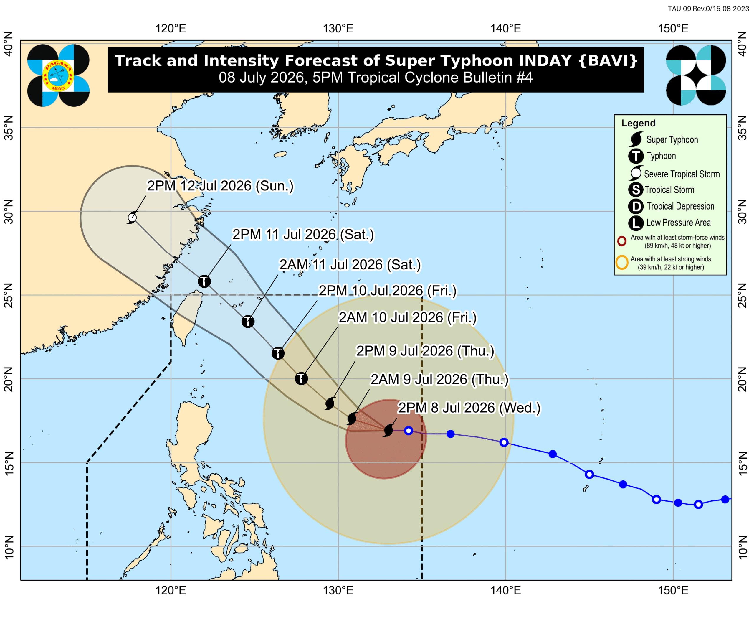
MANILA, Philippines – The outer bands of Super Typhoon Inday (Bavi) and the southwest monsoon or habagat could bring scattered rain and thunderstorms to parts of the country, the weather bureau said on Wednesday afternoon, July 8. Inday was last spotted 1,170 kilometers east of Northern Luzon, moving west at 20 kilometers per hour (km/h). The super typhoon currently has maximum sustained winds of 195 km/h and gustiness of up to 240 km/h, but it could weaken into a typhoon by Thursday evening, July 9, or early Friday morning, July 10. In its 5 pm bulletin on Wednesday, the Philippine Atmospheric, Geophysical, and Astronomical Services Administration (PAGASA) said Inday remains likely to stay over the Philippine Sea. Inday may be nearest to extreme Northern Luzon by Friday evening or Saturday morning, July 11, before heading toward Japan’s southern islands and the sea north of Taiwan. As a result, from Friday afternoon to Saturday afternoon, Batanes is likely to have moderate to heavy rain (50-100 millimeters). While Inday’s center is far from land, its outer rainbands may affect Eastern Visayas and Bicol on Wednesday evening. Flash floods and landslides are possible. Also on Wednesday evening, the southwest monsoon could bring scattered rain and thunderstorms to Palawan, Antique, Iloilo, Guimaras, Negros Occidental, Negros Oriental, the Zamboanga Peninsula, the Bangsamoro Autonomous Region in Muslim Mindanao, Lanao del Norte, Sultan Kudarat, Sarangani, and South Cotabato, as well as isolated rain showers or thunderstorms to the rest of the Visayas and the rest of Mindanao. The separate three-day rainfall outlook for the southwest monsoon shows the following areas may see the most rain, as Inday will be enhancing the habagat: Wednesday afternoon, July 8, to Thursday afternoon, July 9 Moderate to heavy rain (50-100 mm): Antique, Negros Occidental, Sultan Kudarat, Sarangani Thursday afternoon, July 9, to Friday afternoon, July 10 Moderate to heavy rain (50-100 mm): Occidental Mindoro, Palawan, Antique, Iloilo, Guimaras, Negros Occidental, Negros Oriental, Zamboanga del Sur, Lanao del Norte, Lanao del Sur Friday afternoon, July 10, to Saturday afternoon, July 11 Heavy to intense rain (100-200 mm): Occidental Mindoro, Antique Moderate to heavy rain (50-100 mm): Zambales, Bataan, Pampanga, Bulacan, Metro Manila, Cavite, Batangas, Oriental Mindoro, Romblon, Palawan, Aklan, Iloilo, Guimaras, Negros Occidental, Negros Oriental, Zamboanga del Sur, Lanao del Norte Floods and landslides are likely. Meanwhile, Inday will bring strong winds to the following areas under Signal No. 1: llocos Norte Apayao northern part of Abra (Tineg, Lagayan, Danglas, San Juan, Lagangilang, Licuan-Baay, Malibcong, Lacub, Daguioman, Dolores, La Paz) Kalinga eastern part of Mountain Province (Natonin, Paracelis) eastern part of Ifugao (Aguinaldo, Alfonso Lista) Batanes Cagayan including Babuyan Islands Isabela northeastern part of Quirino (Maddela) northern part of Aurora (Dilasag, Casiguran) northern and central parts of Catanduanes (Pandan, Caramoran, Bagamanoc, Panganiban, Viga, Gigmoto, Baras, San Miguel) The highest possible tropical cyclone wind signal due to Inday could be Signal No. 2 or 3. The southwest monsoon and the periphery or outer bands of the super typhoon are also bringing strong to gale-force gusts to these areas: Wednesday, July 8 Pangasinan, Zambales, Bataan, Calabarzon, most of Mimaropa, Bicol, most of Visayas, most of Mindanao Thursday, July 9, and Friday, July 10 most of the country In the next 24 hours, moderate to rough sea conditions will persist in seaboards affected by Inday and the southwest monsoon. Up to very rough seas (travel is risky for all vessels) Seaboard of Isabela; eastern seaboards of Batanes and Cagayan including Babuyan Islands – waves up to 5 meters high Seaboard of Camarines Norte; remaining seaboards of Batanes and Cagayan including Babuyan Islands; northern seaboards of Aurora, Camarines Sur, and Eastern Samar; northern and eastern seaboards of Polillo Islands and Catanduanes; eastern seaboard of Northern Samar – waves up to 4.5 meters high Up to rough seas (small vessels should not venture out to sea) Eastern seaboard of Davao Oriental; remaining seaboards of Aurora and Eastern Samar; northern seaboard of Quezon – waves up to 4 meters high Eastern seaboards of Albay, Sorsogon, Dinagat Islands, Bucas Grande-Siargao Islands, and Surigao del Norte; northern seaboard of Northern Samar – waves up to 3.5 meters high Up to moderate to rough seas (small vessels should take precautionary measures or avoid sailing, if possible) Seaboards of Southern Leyte and Kalayaan Islands; remaining seaboards of Surigao del Norte including Bucas Grande-Siargao Islands; southeastern seaboard of Davao Occidental; western seaboard of Masbate – waves up to 2.5 meters high Seaboards of Siquijor, Camiguin, and Agusan del Norte; northern seaboard of Ilocos Norte; remaining seaboards of Quezon, Albay, Sorsogon, Masbate, Romblon, Northern Samar, and Eastern Samar; southern seaboards of Bohol and Cagayancillo Islands; western seaboard of mainland Palawan – waves up to 2 meters high Inday might exit the Philippine Area of Responsibility (PAR) by Saturday, and make landfall in China by Sunday, July 12. Inday is the country’s ninth tropical cyclone for 2026, and the second for July. The weather bureau earlier said two to four tropical cyclones may form within or enter PAR during the month. – Rappler.com

多角的分析

経済的影響

台風インデイの接近は、フィリピン経済に直接的な影響を与える可能性があります。特に農業分野では、収穫期を迎えている地域での被害が懸念されます。また、インフラへの被害が発生した場合、復旧には多額の費用がかかり、政府の財政にも負担となります。しかし、今回の台風はフィリピン本土から離れた海上に留まる可能性が高く、週末にかけての降雨も散発的であるため、経済全体への壊滅的な影響は限定的と見られます。ただし、交通網の寸断や物流の遅延は、短期的な物価上昇を引き起こす可能性があります。

投資家心理

投資家にとって、台風によるインフラ被害や農業への影響は、関連企業の業績に短期的な不確実性をもたらす可能性があります。しかし、インデイの進路がフィリピン本土から離れていることから、大規模な経済的打撃が予想される状況ではありません。むしろ、復旧・復興需要の発生による建設関連企業への追い風や、気象情報サービス、防災関連技術への関心が高まる可能性も考えられます。長期的な視点では、気候変動への適応策を講じる企業の評価が高まるでしょう。

社会的影響

台風インデイの影響は、特に沿岸部や低地の住民にとって、洪水や土砂災害のリスクを高めます。PAGASAが発表した降雨予測に基づくと、アンティーケ州、ネグロス・オクシデンタル州、オクシデンタル・ミンドロ州などの地域では、生活への直接的な影響が懸念されます。外出制限や避難勧告が出される可能性があり、地域コミュニティの連携や行政の避難支援体制が重要となります。また、交通網の混乱は、日々の生活物資の調達や移動にも支障をきたす可能性があります。

市民の声

今回の台風インデイの接近は、フィリピン国民、特に水曜日から土曜日にかけて雨や雷雨が予想される地域に住む人々にとって、直接的な生活への影響をもたらします。外出の制限、交通機関の遅延、そして何よりも洪水や土砂災害の危険性が懸念されます。PAGASAが発表している降雨予測や風速情報に注意を払い、必要に応じて避難の準備をすることが求められます。特に、低地や河川沿いに住む人々は、自治体からの情報に耳を傾け、安全確保に努める必要があります。週末の予定が変更になる可能性も高いため、最新の気象情報を常に確認することが重要です。

背景・歴史的文脈

フィリピンは太平洋の「火の輪」と呼ばれる地震・火山活動が活発な地域に位置し、さらに台風銀座と呼ばれる熱帯低気圧の発生・進路上にあるため、自然災害が多い国として知られています。年間平均で約20個の台風がフィリピンに接近または上陸し、そのうち数個は大型または猛烈な勢力となります。特に、南西モンスーン(ハバガット)が活発化する時期には、台風の接近がなくても大雨をもたらし、洪水や土砂災害のリスクを高めます。今回の台風インデイの進路は、フィリピン本土への直接的な影響は少ないものの、その外縁とハバガットの組み合わせが、広範囲に雨を降らせる典型的なパターンを示しています。過去の経験から、フィリピン政府と国民は、このような気象現象への備えと迅速な対応に慣れていますが、気候変動の影響による災害の激甚化も懸念されています。

原文ソース

Rappler Philippines

原文を読む