Storm Outside PAR May Intensify Into Super Typhoon Next Week
A tropical storm currently outside the Philippine Area of Responsibility (PAR) is forecast to intensify into a super typhoon by mid-next week, according to the Philippine Atmospheric, Geophysical and Astronomical Services Administration (Pagasa). The storm will be named Inday.
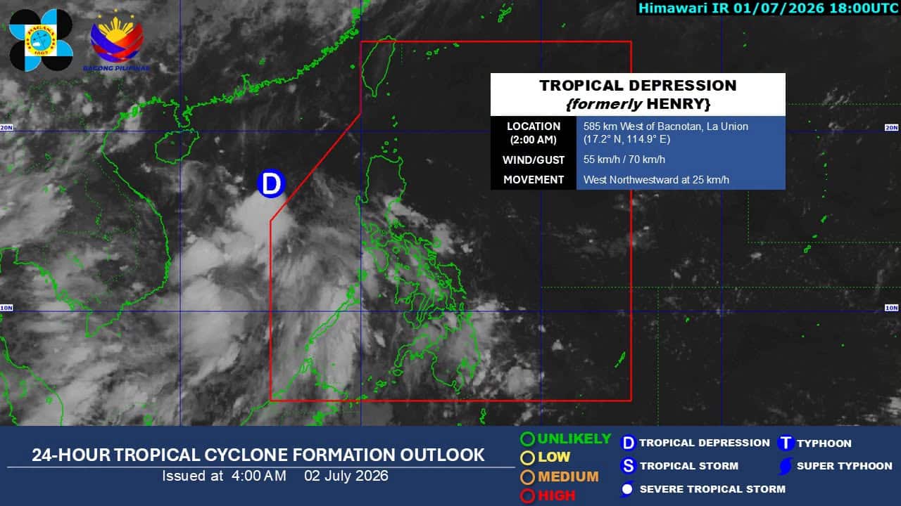
A tropical storm (TS) currently outside the Philippine area of responsibility (PAR) is likely to develop into a super typhoon next week, according to the state weather bureau. Philippine Atmospheric, Geophysical and Astronomical Services Administration (Pagasa) weather specialist Leanne Loreto said during its 5 am weather advisory that the weather disturbance outside the country may enter either Wednesday or Thursday next week. “We see this tropical storm intensifying further in the coming days, and it is possible that it will enter our area of responsibility by the middle of next week,” Loreto said. Loreto said that forecasts show the system could strengthen into a typhoon or even a super typhoon as it approaches the country, although its track and intensity remain uncertain. It will be given the name Inday. “And based on what we are seeing, it could still reach typhoon or super typhoon category,” Loreto reported. She said there is still a high level of uncertainty regarding the potential scenario of the TS, although it is likely to enhance southwest monsoon, or habagat. “There is still a high level of uncertainty regarding the potential scenario for this new tropical cyclone. Based on our observations, this storm will draw in the southwest monsoon,” Loreto explained. Meanwhile, Tropical depression Henry exited PAR at around 8 pm on Wednesday and was last located 610 kilometers west of Bacnotan, La Union, moving west-northwest at 25 kilometers per hour. As of 3 a.m. Thursday, Henry packed maximum sustained winds of 55 kph and gusts of up to 70 kph. Despite its exit, Pagasa said the combined effects of Henry’s outer circulation and southwest monsoon or habagat will continue to bring strong to gale-force gusts over Batanes, Cagayan, Pangasinan, Zambales, Bataan, and Palawan. The southwest monsoon will also affect the western sections of Southern Luzon, Visayas and Mindanao, bringing cloudy skies with scattered rains and thunderstorms over Palawan and Occidental Mindoro. Zamboanga Peninsula, Basilan, Tawi-Tawi, and Antique may experience partly cloudy to cloudy skies with isolated rain showers or thunderstorms due to habagat. Meanwhile, cloudy skies with scattered rain may prevail over Eastern Visayas, Bicol Region, Caraga, Davao Region, and Quezon due to easterlies. Metro Manila and the rest of the country may experience gloomy skies with occasional rains or thunderstorms due to localized thunderstorms, according to Pagasa.
多角的分析
熱帯低気圧のスーパー台風への発達は、フィリピン経済に多大な影響を与える可能性がある。特に農業分野では、収穫前の農作物への被害が懸念され、食料価格の高騰につながる恐れがある。また、インフラへの被害は復旧に多額の費用を要し、経済成長を鈍化させる要因となりうる。海外からの投資家にとっては、自然災害リスクの増大は投資判断における重要な要素となるため、今後の被害予測と政府の対応策が注視されるだろう。
フィリピンにおける熱帯低気圧の頻繁な発生と、スーパー台風への発達の可能性は、投資家にとって重要なリスク要因である。特に、インフラ、不動産、農業関連セクターへの投資は、直接的な被害を受けるリスクが高い。投資家は、保険カバレッジの確認、サプライチェーンのレジリエンス評価、および政府の災害対策への信頼度などを考慮する必要がある。長期的な視点では、気候変動への適応策に投資する企業や、災害復旧・インフラ整備関連のプロジェクトへの関心が高まる可能性もある。
熱帯低気圧のスーパー台風への発達は、フィリピン国民の生活に直接的な影響を与える。特に沿岸部や低地の住民は、暴風雨、高潮、洪水のリスクに直面し、避難や家屋の損壊、インフラの機能停止といった困難に直面する。過去の台風被害の経験から、食料、水、医療へのアクセスが困難になることも予想され、脆弱なコミュニティほど深刻な影響を受ける。社会インフラの脆弱性や、避難計画の実効性が問われることになる。
来週、フィリピン管轄区域外の熱帯低気圧がスーパー台風に発達する可能性があるというニュースは、マニラ首都圏に住む市民にとって、日々の生活への懸念を増大させる。過去の台風被害では、交通網の麻痺、停電、食料品や生活必需品の不足が発生し、生活が大きく乱された。特に、地方から上京してきている人々は、故郷の家族への心配も募る。政府からの正確な情報提供と、迅速な避難勧告、そして万が一の際の支援体制の強化が、市民の不安を和らげる鍵となるだろう。
背景・歴史的文脈
フィリピンは、太平洋の「火山の輪」と呼ばれる地震多発地帯に位置し、さらに太平洋の西部に位置するため、熱帯低気圧が発達しやすい環境にある。年間平均20個以上の熱帯低気圧がフィリピン管轄区域(PAR)に進入または影響を与え、そのうち数個が強力な台風となる。特に、2013年の台風ハイエン(ヨランダ)は、甚大な被害をもたらし、フィリピンの災害対策の脆弱性を浮き彫りにした。このため、フィリピン気象庁(Pagasa)は、熱帯低気圧の監視と早期警報に力を入れているが、気候変動による異常気象の頻発化・激甚化は、常に警戒を要する課題となっている。
原文ソース
Inquirer NewsInfo