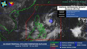
Tropical Depression Kiyapo Likely to Intensify into Storm; Signal No. 1 Up in Over a Dozen Areas
Tropical Depression Kiyapo is expected to intensify into a tropical storm, prompting the hoisting of Storm Signal No. 1 in over a dozen areas across northern Philippines. Impacts are anticipated over the weekend.
This article requires PRO
This article is outside the free access window or is a special report. PRO unlocks it and the full archive.
Related articles
- MMDA to Build 3 Rainwater Facilities in Manila to Combat Flooding
The Metropolitan Manila Development Authority (MMDA) will construct three rainwater impounding facilities (RIFs) in Manila as part of efforts to mitigate flooding in the capital. An agreement was signed between the MMDA and the City of Manila to implement nature-based solutions.
- Heavy Rains Forecast for Luzon, Including Metro Manila, Due to Localized Thunderstorms
The Philippine weather bureau forecasts heavy to intense rains in parts of Metro Manila and Luzon on Tuesday afternoon due to localized thunderstorms. Residents in affected areas are advised to be vigilant against potential flooding and landslides.
- 4 Rehabilitated Wild Animals Released into Aurora Protected Area
IBA, Zambales — Four rehabilitated wild animals, including a Philippine serpent eagle, two Philippine cobras, and a reticulated python, have been released into designated areas within the Aurora Memorial National Park, the Department of Environment and Natural Resources office in Central Luzon announced.
- Sibuco, Zamboanga del Norte Extends Class Suspensions Due to Persistent Rains
Classes in Sibuco, Zamboanga del Norte, remain suspended for all levels due to persistent heavy rains and inclement weather from the Intertropical Convergence Zone (ITCZ). The mayor extended the suspension to ensure residents' safety.