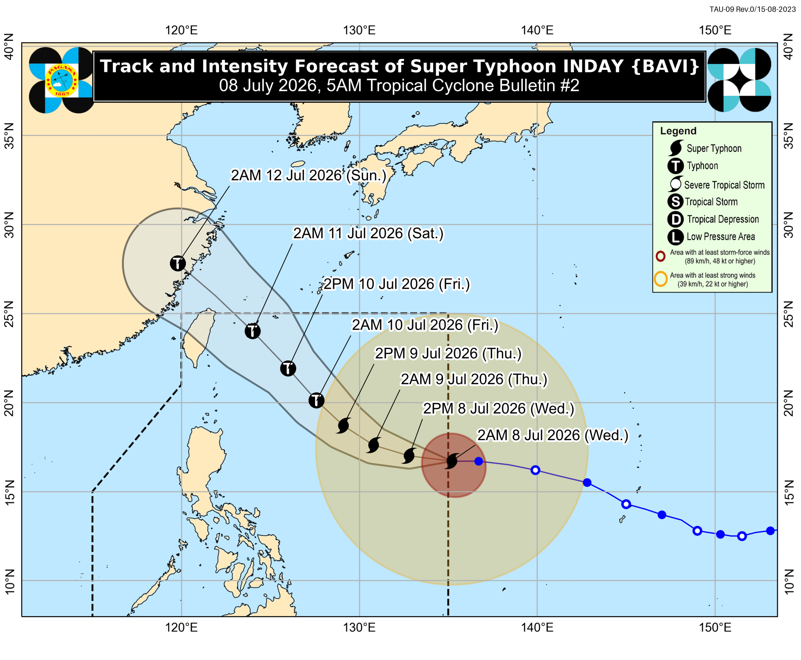
Super Typhoon Inday enters PAR; Storm signals up in more areas
Super Typhoon Inday (Bavi) has entered the Philippine Area of Responsibility, prompting the hoisting of Storm Signal No. 1 in several areas, including northeastern Cagayan. While not expected to make landfall, it will enhance the southwest monsoon, potentially causing adverse weather nationwide.
MANILA, Philippines – Signal No. 1 was raised for more areas before dawn on Wednesday, July 8, as Super Typhoon Inday (Bavi) entered the Philippine Area of Responsibility (PAR) at 3 am. Signal No. 1 was initially raised for the northeastern portion of Cagayan late Tuesday evening, July 7, even before Inday’s entry into PAR. The raising of the lowest wind signal also prompted the weather bureau to already assign a local name for the super typhoon, breaking away from its usual practice of giving a local name only once a tropical cyclone has entered PAR. The Philippine Atmospheric, Geophysical, and Astronomical Services Administration (PAGASA) said Inday was located 1,405 kilometers east of Northern Luzon as of 4 am on Wednesday, moving west at a slightly slower 25 kilometers per hour from 30 km/h. The super typhoon still has maximum sustained winds of 185 km/h and gustiness of up to 230 km/h. It is expected to stay over the Philippine Sea, and could be “nearest to extreme Northern Luzon by Friday, July 10, before heading towards the southern islands of Japan and the sea north of Taiwan.” Taiwan itself is within PAR. Although Inday is not seen to make landfall in the Philippines, it will still affect parts of the country and enhance the southwest monsoon or habagat. The areas below, all in Luzon, are under Signal No. 1 as of 5 am on Wednesday. This means they will have strong winds from the super typhoon. Batanes Cagayan including Babuyan Islands northern and central parts of Isabela (Santo Tomas, Aurora, Santa Maria, Quezon, San Mariano, Naguilian, Dinapigue, Roxas, Luna, Delfin Albano, Cauayan City, San Pablo, Ilagan City, Benito Soliven, Tumauini, Cabagan, Reina Mercedes, San Manuel, Palanan, Cabatuan, Quirino, Divilacan, Gamu, Mallig, Maconacon, Burgos, San Guillermo, Angadanan, Alicia, San Mateo) Apayao eastern part of Kalinga (Pinukpuk, Tabuk City, Rizal) northern part of Aurora (Dilasag) northern and central parts of Catanduanes (Pandan, Caramoran, Bagamanoc, Panganiban, Viga, Gigmoto, Baras, San Miguel) The highest possible tropical cyclone wind signal due to Inday could be Signal No. 2 or 3. PAGASA also said the enhanced southwest monsoon and the periphery or outer bands of the super typhoon will bring strong to gale-force gusts to these areas: Wednesday, July 8 Pangasinan, Zambales, Bataan, Calabarzon, most of Mimaropa, Bicol, most of Visayas, most of Mindanao Thursday, July 9, and Friday, July 10 most of the country As for rainfall, PAGASA said Inday will trigger moderate to heavy rain (50-100 millimeters) in Batanes on Friday. Meanwhile, on Wednesday, the southwest monsoon is bringing scattered rain and thunderstorms to the Zamboanga Peninsula, Bangsamoro Autonomous Region in Muslim Mindanao, Lanao del Norte, Sultan Kudarat, Sarangani, South Cotabato, Antique, Iloilo, Guimaras, Negros Occidental, and Negros Oriental, as well as isolated rain showers or thunderstorms to the rest of Mindanao, the rest of the Visayas, and Palawan. Over the next three days, rainfall from the southwest monsoon might be heaviest in these areas: Moderate to heavy rain (50-100 mm): Sultan Kudarat, Sarangani Thursday, July 9 Moderate to heavy rain (50-100 mm): Occidental Mindoro, Palawan, Antique, Negros Occidental Friday, July 10 Heavy to intense rain (100-200 mm): Occidental Mindoro, Antique Moderate to heavy rain (50-100 mm): Zambales, Bataan, Metro Manila, Cavite, Batangas, Palawan, Guimaras, Iloilo, Negros Occidental, Negros Oriental, Lanao del Norte, Lanao del Sur Floods and landslides are likely. PAGASA also updated warnings for coastal waters on Wednesday, with travel now risky for all vessels in several seaboards on the eastern side of the country. Up to very rough seas (travel is risky for all vessels) Seaboard of Isabela; northern seaboard of Aurora; northern and eastern seaboards of Catanduanes; eastern seaboard of Northern Samar – waves up to 4.5 meters high Up to rough seas (small vessels should not venture out to sea) Northern and eastern seaboards of Batanes and Polillo Islands; eastern seaboards of Cagayan, Albay, Sorsogon, Eastern Samar, and Dinagat Islands; remaining seaboard of Aurora; northern seaboards of mainland Quezon, Camarines Norte, Camarines Sur, and Northern Samar – waves up to 4 meters high Remaining seaboards of Batanes and Cagayan; eastern seaboards of Bucas Grande-Siargao Islands and Surigao del Sur; eastern and southern seaboards of Davao Oriental – waves up to 3.5 meters high Up to moderate to rough seas (small vessels should take precautionary measures or avoid sailing, if possible) Southern seaboard of Southern Leyte; remaining seaboards of Surigao del Norte; southeastern seaboard of Davao Occidental; northern and western seaboards of Kalayaan Islands – waves up to 2.5 meters high Southern seaboard of Bohol; northern seaboard of Camiguin; remaining seaboards of Kalayaan Islands – waves up to 2 meters high According to PAGASA, Inday may be downgraded to a typhoon by Thursday afternoon or evening, July 9 — still a strong tropical cyclone nonetheless. It could leave PAR by Saturday, July 11, and make landfall in China by Sunday, July 12. Inday is the country’s ninth tropical cyclone for 2026, and the second for July. The weather bureau earlier said two to four tropical cyclones may form within or enter PAR during the month. – Rappler.com
多角的分析
台風インディの通過は、直接的な被害は限定的と見られるものの、フィリピン全土に広がる南西モンスーンの強化を通じて、農作物への影響やインフラへの間接的な損害を引き起こす可能性があります。特に、影響を受ける可能性のある地域には農業が盛んな地域も含まれており、食料供給への一時的な影響も懸念されます。また、沿岸部での船舶運航の制限は、物流コストの上昇や漁業への打撃につながる可能性があります。
今回の台風インディは、フィリピン本土への直接的な上陸が予想されていないため、短期的な市場への大きな影響は限定的と考えられます。しかし、長引く南西モンスーンによる広範な悪天候は、インフラ関連企業や、農産物・水産物を扱う企業のサプライチェーンに一時的な混乱をもたらすリスクをはらんでいます。投資家は、これらのセクターにおける短期的な業績変動に注意を払う必要があります。
台風インディの影響で、フィリピン北部を中心にシグナル1が発令され、一部地域では強風や大雨が予想されています。これにより、漁業や農業に依存するコミュニティでは、生計手段への影響が懸念されます。また、広範な地域で南西モンスーンが強化されることで、都市部では交通機関の遅延や浸水、地方では土砂災害のリスクが増大し、住民の日常生活に支障をきたす可能性があります。特に、沿岸部では高波による漁船の出漁制限が、漁師たちの収入に直結する問題となります。
台風インディの接近により、フィリピン北部では暴風警報が発令され、多くの地域で南西モンスーンが強化されることが予想されています。これにより、外出や農作業、漁業などが制限され、日々の生活に影響が出ます。特に、低地や山間部に住む人々は、鉄砲水や土砂災害の危険にさらされる可能性があります。PAGASAからの最新情報に注意し、早めの避難や備えが重要となります。
背景・歴史的文脈
フィリピンは太平洋の「火山の輪」に位置し、世界で最も台風の影響を受けやすい国の一つである。熱帯低気圧は毎年平均して約20個がフィリピン空域(PAR)に進入し、そのうち約8~9個が上陸するとされている。特に7月と8月は台風シーズンであり、過去には大規模な被害をもたらした台風も少なくない。2013年の台風ヨランダ(ハイエン)は、甚大な被害をもたらし、フィリピンの防災・減災体制の強化を促す契機となった。今回の台風インディは、こうしたフィリピンの地理的・気象的脆弱性を改めて浮き彫りにしている。
原文ソース
Rappler Philippines