LPA East of Philippines May Develop into Tropical Depression
The Philippine Atmospheric, Geophysical and Astronomical Services Administration (PAGASA) announced that a low-pressure area (LPA) east of Samar Island is likely to develop into a tropical depression within 24 hours. The system is expected to bring heavy rains to various parts of the country over the next few days, even before its development into a storm.
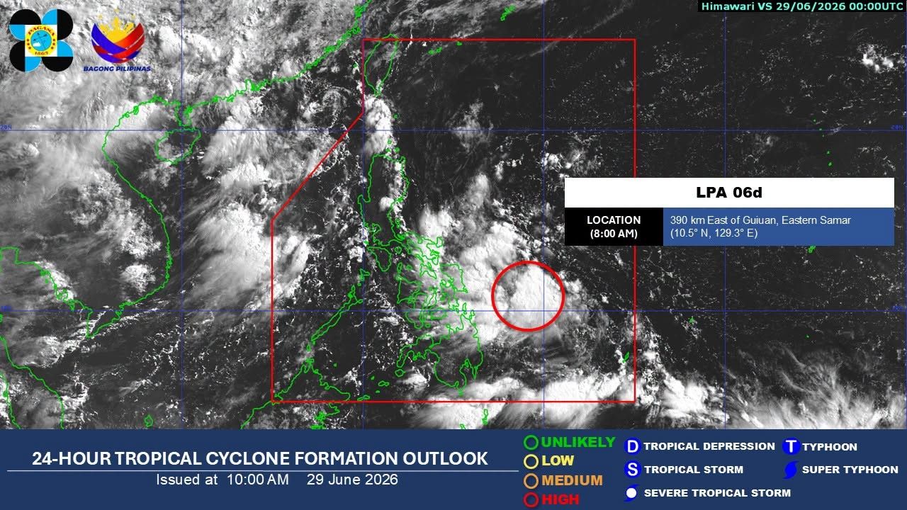
MANILA, Philippines — A low-pressure area east of the Philippines is likely to develop into a tropical depression within 24 hours, state weather bureau PAGASA said Monday, June 29. As of 8 a.m. on Monday, PAGASA estimated the low-pressure area at 390 kilometers east of Guiuan, Eastern Samar. The weather system is expected to bring heavy rain to several parts of the country over the next few days, even before it develops into a storm. From Monday until noon Tuesday, June 30, PAGASA said 50 to 100 millimeters of rain may fall over Sorsogon, Albay, Masbate, Northern Samar, Eastern Samar, Samar, Biliran, Leyte and Romblon. The same amount of rain is expected from Tuesday noon until Wednesday noon, July 1, over Palawan, Occidental Mindoro, Oriental Mindoro, Romblon, Marinduque, Masbate and Sorsogon. From Wednesday noon until Thursday noon, July 2, heavy rain is expected to persist over Occidental Mindoro, Oriental Mindoro and Palawan. PAGASA warned that heavy rainfall may trigger flooding and rain-induced landslides, especially in areas that are prone to these hazards. Residents in affected areas were advised to monitor updates from PAGASA and local disaster risk reduction offices. Philippines is situated in a typhoon-prone region and is frequently affected by multiple typhoons and tropical depressions throughout the year. During the rainy season (June to November), these weather phenomena occur frequently, significantly impacting infrastructure and people's lives. The potential development of this LPA is an example of the Philippines' vulnerability to climate change.
多角的分析
低気圧の発達は、農業セクターに直接的な影響を与える可能性があります。特に、収穫期に近い農作物は、大雨やそれに伴う洪水によって大きな被害を受けるリスクがあります。これは食料供給の不安定化や、農家の収入減少につながり、インフレ圧力の一因となることも考えられます。また、インフラへの被害は、物流コストの上昇や経済活動の停滞を招く可能性があります。
短期的な投資家にとっては、インフラ関連企業や保険会社の株価に一時的な影響が出る可能性があります。しかし、長期的な視点では、フィリピンの自然災害への脆弱性は、投資判断において常に考慮されるべきリスク要因です。災害復旧やインフラ強化に関連する投資機会も同時に生まれる可能性があります。
今回の熱帯低気圧の接近は、特に低地や災害リスクの高い地域に住む住民にとって、直接的な脅威となります。避難の必要性、家屋の損壊、水や食料へのアクセスの困難さなどが懸念されます。また、災害発生時の情報伝達の遅れや、避難所の衛生状態なども、社会的な課題として浮上する可能性があります。地方自治体の防災体制の整備が問われます。
今回の熱帯低気圧は、特にソルソゴン州、アルバイ州、マスバテ州、北サマール州、東サマール州、サマール州、ビリル島、レイテ島、ロンブロン州、パラワン州、西ミンドロ州、東ミンドロ州、マルンドゥケ州といった地域に住む人々の生活に直接的な影響を与えます。これらの地域では、大雨による洪水や土砂崩れの危険性が高まり、日常生活の中断や、場合によっては避難を余儀なくされる可能性があります。特に、インフラの脆弱な地域では、停電や通信網の寸断も懸念され、情報収集や緊急連絡が困難になることも考えられます。
背景・歴史的文脈
フィリピンは太平洋の「火山の輪」と「台風銀座」に位置し、地震、火山噴火、そして熱帯低気圧の影響を常に受ける地理的条件にあります。特に熱帯低気圧は、年間を通じて平均20個以上がフィリピン付近を通過または上陸し、甚大な被害をもたらしてきました。1970年代以降、気象観測技術の進歩により、熱帯低気圧の予測精度は向上していますが、都市化の進展や気候変動による異常気象の頻発化は、災害リスクを増大させる要因となっています。過去の大型台風による被害経験から、フィリピン政府は防災・減災対策を強化してきましたが、依然としてインフラの脆弱性や広範な貧困層の存在が、災害からの復旧を困難にしています。
原文ソース
Philstar Nation