Cambodia Forecast: Rain, Thunderstorms Expected Amidst Tropical Disturbances
Environment
2026年7月6日
3
AKP Khmer

Cambodia Forecast: Rain, Thunderstorms Expected Amidst Tropical Disturbances

AI サマリー

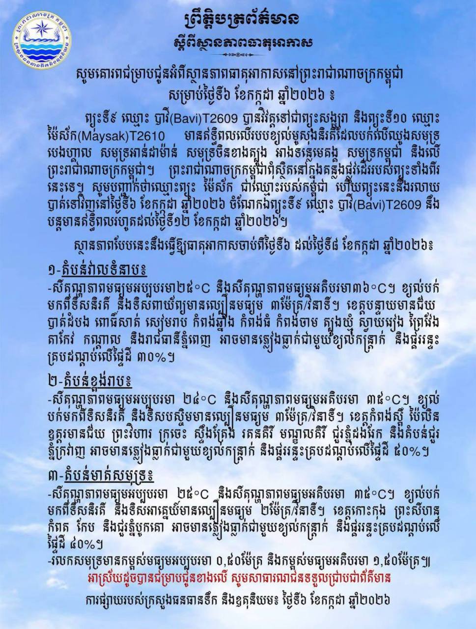
Cambodia's Ministry of Water Resources and Meteorology forecasts rain, strong winds, and thunderstorms nationwide from July 6-8 due to tropical depressions Bavi and Maysak. Highland areas face a 50% chance of impact.

Cambodia is bracing for potential heavy rainfall, strong winds, and thunderstorms as tropical depressions "Bavi" (T2609) and "Maysak" (T2610) influence the region. The Ministry of Water Resources and Meteorology issued a notification on July 6, stating that these systems are affecting the southwest monsoon blowing over the Bay of Bengal, Andaman Sea, South China Sea, Mekong River basin, Cambodian Sea, and the Kingdom of Cambodia. However, the Kingdom of Cambodia is not in the direct path of these two storms. "Maysak" is a storm named by Cambodia and is expected to dissipate on July 6, 2026. "Bavi," meanwhile, is forecast to continue its influence until July 12, 2026. The ministry detailed the expected weather conditions from July 6 to 8, 2026: 1. Plains Areas: Minimum temperature 25°C, maximum 36°C. Winds from the southwest and northwest at an average speed of 3 meters/second. Provinces including Banteay Meanchey, Battambang, Pursat, Siem Reap, Kampong Chhnang, Kampong Thom, Kampong Cham, Tboung Khmum, Svay Rieng, Prey Veng, Takeo, Kandal, and Phnom Penh capital will experience a 30% chance of rain, strong winds, and thunderstorms. 2. Highland Areas: Minimum temperature 24°C, maximum 35°C. Winds from the southwest and west at an average speed of 3 meters/second. Provinces such as Kampong Speu, Pailin, Oddar Meanchey, Preah Vihear, Kratie, Stung Treng, Ratanakiri, Mondulkiri, and areas around the Dangrek and Cardamom mountains face a 50% chance of rain, strong winds, and thunderstorms. 3. Coastal Areas: Minimum temperature 25°C, maximum 35°C. Winds from the southwest and southeast at an average speed of 2 meters/second. Provinces including Koh Kong, Preah Sihanouk, Kampot, Kep, and areas around Bokor Mountain will have a 40% chance of rain, strong winds, and thunderstorms. Sea waves are expected to be between 0.50 and 1.50 meters high. Source: AKP Khmer

多角的分析

経済的影響

今回の気象情報は、直接的な経済活動への影響は限定的であるものの、農作物への被害リスクを示唆している。特に、カンボジア経済の根幹をなす農業セクターでは、収穫期や作物の種類によっては、一時的な収量低下や品質劣化を引き起こす可能性がある。これは、農家の収入減に直結し、ひいては国内の食料品価格にも影響を与える可能性がある。ただし、熱帯低気圧が直接カンボジアを通過しないことから、広範なインフラ被害やサプライチェーンの寸断といった深刻な経済的打撃は避けられるとみられる。

投資家心理

投資家にとっては、この気象情報は短期的なリスク要因として認識されるだろう。特に農業関連企業や、インフラへの投資を行っている企業は、一時的な操業遅延や予期せぬコスト増に直面する可能性がある。しかし、熱帯低気圧の進路がカンボジアを直撃しないという点は、投資環境の大きな悪化を防ぐ要因となる。むしろ、長期的な視点では、気象災害への対応能力を高めるためのインフラ投資(例:灌漑システム、排水設備)への関心が高まる可能性も考えられる。

社会的影響

今回の気象予報は、カンボジア国民の日常生活に直接的な影響を与える。特に、農村部や沿岸部では、大雨や強風による住居への被害、交通網の寸断、そして農作物への影響が懸念される。プノンペンなどの都市部でも、道路の冠水やインフラへの一時的な影響が生じる可能性がある。市民は、不要不急の外出を控え、安全確保に努める必要がある。また、漁業従事者や沿岸部の住民は、海の状況悪化による漁獲量の減少や、海上での安全確保に注意が必要となる。

市民の声

今回の予報は、カンボジア市民、特に農業に依存している人々や沿岸部に住む人々にとって、直接的な生活への影響を意味する。農家にとっては、収穫への影響が収入に直結するため、不安材料となる。沿岸部の住民は、強風や高波による家屋への被害や、漁業への影響を心配するだろう。プノンペン市民も、一時的な道路冠水や交通の乱れを経験する可能性がある。市民は、最新の気象情報を確認し、安全対策を講じることが重要となる。

背景・歴史的文脈

カンボジアは熱帯モンスーン気候に属し、年間を通じて降水量が多い。特に雨季(5月~10月)には、熱帯低気圧やモンスーンの影響で、大雨や洪水が発生しやすい。過去にも、熱帯低気圧がカンボジア付近を通過し、甚大な被害をもたらした事例がある。2020年には、熱帯低気圧「リンパ」がカンボジアに上陸し、広範囲で洪水が発生、多数の家屋が損壊し、インフラにも大きな被害が出た。これらの経験から、カンボジア政府は気象情報の発信と防災対策の強化に努めているが、依然として気象災害への脆弱性は高い。

原文ソース

AKP Khmer

原文を読む