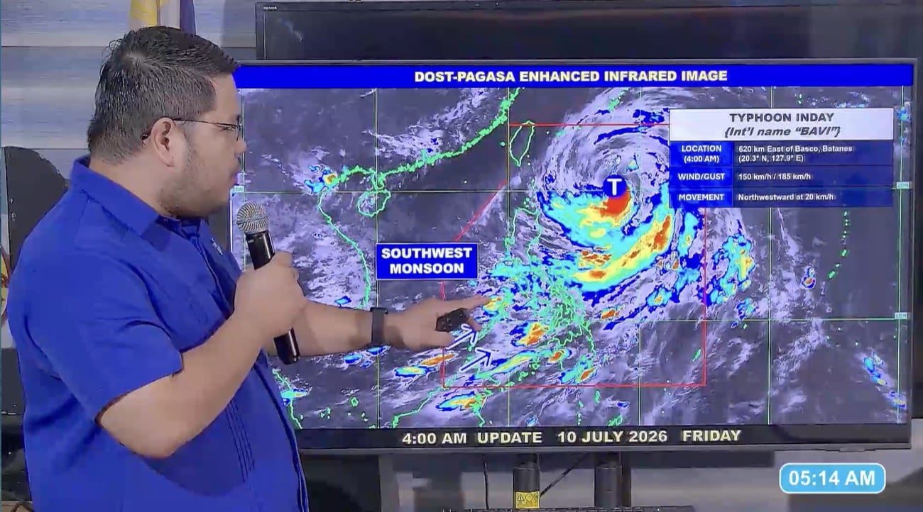
Typhoon Inday: Wind signals hoisted in more areas in Northern Luzon
Environment
2026年7月10日
4
Inquirer NewsInfo

Typhoon Inday: Wind signals hoisted in more areas in Northern Luzon

AI サマリー

Tropical cyclone wind signals were hoisted in parts of Northern Luzon as Typhoon Inday passed through the northern Philippines. Strong winds and heavy rains are expected, and Inday is forecast to enhance the southwest monsoon, affecting wider areas over the weekend.

MANILA, Philippines — Tropical cyclone wind signals were hoisted in more areas in Northern Luzon due to Typhoon Inday on Friday, July 10. In a 5 a.m. weather advisory, Philippine Atmospheric, Geophysical and Astronomical Services Administration (Pagasa) issued Wind Signal No. 1 on the following areas: Meanwhile, Batanes, the eastern portion of Babuyan Islands, and the northeastern portion of mainland Cagayan were placed under Wind Signal No. 2. READ: Batanes, 2 areas under signal No, 2 as typhoon Inday hold strength As of 4 a.m., Inday, located 620 kilometers east of Basco, Batanes, packs maximum sustained winds of 150 kilometers per hour near the center and gustiness of 185 kilometers per hour. Strong to gale-force winds are expected to affect the seaboards of Extreme Northern Luzon, the northern and eastern seaboards of Northern Luzon, as well as the eastern seaboards of Luzon, Pagasa said. Pagasa also issued heavy rainfall warnings over Oriental Mindoro and Antique due to the typhoon, with rainfall projected at 100 to 200 millimeters. Flooding and landslides are possible in the affected areas, according to the weather bureau. Meanwhile, Inday may bring 60 to 100 millimeters of rain over the following: Pagasa weather specialist Obet Badrina said the enhanced southwest monsoon, or habagat, persists to affect the western part of Luzon, Visayas, and Mindanao. “The southwest monsoon continues to prevail, bringing rain to large parts of western Luzon, the Visayas, and Mindanao,” Badrina reported. Inday is forecast to generally move northwestward at 20 kilometers per hour, while remaining over the Philippine Sea, and exit the country by Saturday morning or afternoon, July 11. Despite Inday’s exit, the typhoon is expected to continue to enhance the southwest monsoon, bringing rain over the western sections of Luzon and Visayas, according to Badrina. “It is possible that by tomorrow morning, it will exit the Philippine area of responsibility, however, the southwest monsoon will continue to be enhanced and strengthened by typhoon Inday. Therefore, expect rainfall across large parts of Luzon and Visayas this weekend, especially in the western sections,” Badrina reported. /das

多角的分析

経済的影響

台風インディによる強風と大雨は、農業、特にルソン北部での収穫に直接的な影響を与える可能性がある。また、インフラへの被害は、物流の遅延や復旧コストの増加につながり、短期的な経済活動を停滞させる要因となりうる。フィリピン経済は、気象災害への脆弱性が常に課題となっており、今回の台風もそのリスクを浮き彫りにした。

投資家心理

投資家にとって、この種の気象災害は、保険、建設、農業関連セクターへの影響を注視する必要がある。インフラ被害の規模によっては、サプライチェーンへの影響も懸念され、短期的な市場のボラティリティを高める可能性がある。しかし、復旧需要は建設セクターにとって機会ともなりうる。

社会的影響

ルソン北部沿岸地域や低地帯の住民は、直接的な被害を受ける可能性がある。家屋の損壊、農作物の被害、インフラの寸断は、生活基盤を揺るがす。また、大雨による洪水や地滑りのリスクは、避難生活を余儀なくされる人々を生み出し、社会的な不安を増大させる。特に、貧困層や脆弱なコミュニティは、災害からの回復に長時間を要する傾向がある。

市民の声

台風インディの接近により、ルソン北部では日常生活に大きな影響が出ている。外出の制限、交通機関の麻痺、そして停電のリスクは、市民の安全と利便性を脅かす。また、予期せぬ大雨による洪水や地滑りの可能性は、住民に常に危険と隣り合わせの状況を強いる。週末にかけての雨の予報は、多くの家庭で計画の変更を余儀なくさせるだろう。

背景・歴史的文脈

フィリピンは、太平洋の「火山の輪」に位置し、台風銀座とも呼ばれる地域にあり、年間平均20個以上の台風が接近・上陸する世界有数の災害多発国である。特に、ルソン島北部やビサヤ諸島は、台風の常襲地帯であり、過去には大規模な被害をもたらした台風が多数発生している。これらの地域では、農業や漁業が主要産業であるため、台風による被害は経済的にも社会的にも深刻な影響を及ぼす。気象庁(Pagasa)は、台風の進路予報や警報の発令を通じて、国民の安全確保に努めているが、地球温暖化による気候変動の影響で、台風の強大化や予測困難性の増加が指摘されており、災害対策は常に喫緊の課題となっている。

原文ソース

Inquirer NewsInfo

原文を読む