General articles are free for 24 hours after publish.
Vietnam Central Coast Braces for Heavy Rain and Strong Winds as Tropical Depression Approaches
Vietnam's central coast is bracing for heavy rainfall and strong winds due to an approaching tropical depression. Areas around Quang Tri, Da Nang, and Hue are particularly at risk. Concerns are rising over potential infrastructure damage and flooding.
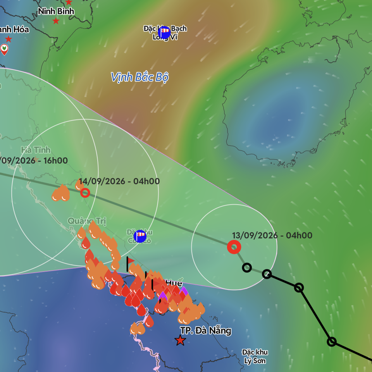
Vietnam's central coast is bracing for heavy rainfall and strong winds as a tropical depression approaches. As of September 13, significant rainfall is concentrated in Hue, Quang Tri, and Ha Tinh provinces. From the late afternoon of the same day, winds along the coast of Quang Tri and Ha Tinh are expected to strengthen, reaching level 6 and gusting to level 8. According to the National Center for Hydro-Meteorological Forecasting, at 4 AM on September 13, the center of the tropical depression was located over the waters of Quang Tri - Da Nang, about 160 km northeast of Hue. The strongest winds near the center are at level 6 (39-49 km/h), with gusts up to level 8. Due to the influence of the tropical depression's circulation, Con Co Island (Quang Tri) experienced winds of level 6 with gusts up to level 8. The area from Quang Tri to Da Nang experienced moderate to heavy rain overnight and early this morning. Today, the tropical depression is forecast to move west-northwest at a speed of about 10 km/h, moving along the coast from Hue northward to Quang Tri and Ha Tinh provinces. By 10 PM tonight, the center of the tropical depression is expected to be over the coastal waters of Quang Tri - Ha Tinh, maintaining its intensity at level 6 with gusts up to level 8. From tonight to early morning of September 14, the tropical depression is likely to make landfall in the northern areas of Quang Tri - Ha Tinh. During September 14, the tropical depression will move deeper inland and weaken into a low-pressure area. Under the influence of the tropical depression, the sea area from Ha Tinh to Da Nang (including Con Co Island) will experience strong winds of level 6 with gusts up to level 8, with waves reaching 2-4 meters, indicating rough seas. Coastal areas should be prepared for potential damage to house roofs, temporary structures, falling trees, billboards, and disruptions to power, communication, and transportation systems. The heavy rainfall is also expected to affect areas from Thanh Hoa to Da Nang, as well as the northern midlands and plains, and the southern parts of Son La, Phu Tho, Tuyen Quang, and Lao Cai provinces. Specifically, from Ha Tinh to Hue, rainfall is predicted to be heavy to very heavy, ranging from 100-200mm, with some areas exceeding 350mm. For Thanh Hoa, Nghe An, and Da Nang, moderate to heavy rain and thunderstorms are expected, with rainfall amounts ranging from 40-70mm, and some areas receiving over 150mm. From tonight, September 13, the northern midlands and plains, and southern parts of Son La and Phu Tho provinces will experience moderate to heavy rain and thunderstorms, with rainfall amounts ranging from 30-60mm, and some areas exceeding 100mm. On September 14, areas from Thanh Hoa to Quang Tri will experience heavy to very heavy rain and thunderstorms, with rainfall amounts ranging from 100-200mm, and some areas exceeding 350mm. For the northern midlands and plains, and southern parts of Son La, Phu Tho, Tuyen Quang, and Lao Cai provinces, and from Thanh Hoa to Quang Tri, moderate to heavy rain and thunderstorms are expected, with rainfall amounts ranging from 40-70mm, and some areas receiving over 150mm. On September 15, the northern midlands and plains, and southern parts of Son La, Phu Tho, Tuyen Quang, and Lao Cai provinces, as well as areas from Thanh Hoa to Quang Tri, will experience moderate to heavy rain and thunderstorms, with rainfall amounts ranging from 30-60mm, and some areas receiving over 100mm. The heavy rains could lead to urban flooding, inundation in industrial zones and low-lying areas, and increase the risk of flash floods and landslides in mountainous regions. This period of heavy rainfall is expected to last until the morning of September 16. Over the next two days, the tropical depression is forecast to move north along the coast from Da Nang to Quang Tri, potentially making landfall and causing heavy rain in areas from Quang Ngai to Nghe An, before moving further north. Source: The Saigon Times
Original source
The Saigon Times