General articles are free for 24 hours after publish.
Heavy Rains Flood Hoi An Ancient Town, Cause Landslides in Central Vietnam
Persistent heavy rains, fueled by a tropical depression, have inundated key roads leading to Hoi An's ancient town in central Vietnam, with water levels reaching up to 50cm. Landslides have occurred in mountainous areas, damaging infrastructure. Authorities have issued evacuation orders and traffic restrictions.
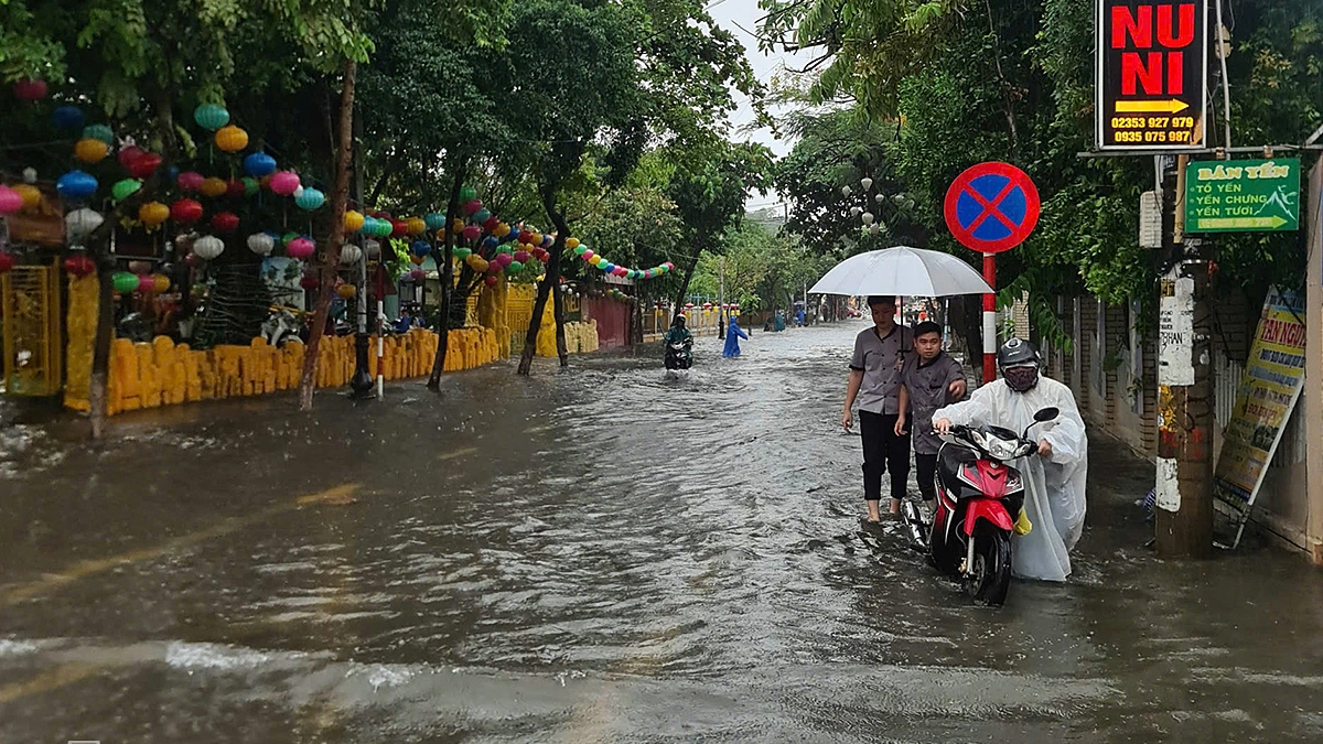
Heavy rains, influenced by a tropical depression, have been persistently falling across central Vietnam from September 11th to the afternoon of September 12th. This has led to significant flooding on major roads leading to the UNESCO World Heritage site of Hoi An Ancient Town, with water levels reaching up to 50cm and causing numerous motorcycles to stall. According to the Central Coastal Hydrometeorological Station, the total rainfall from September 11th to 1 PM on September 12th ranged from 70-150mm in urban areas and 130-230mm in coastal plains and southwestern mountainous regions. Cau Lau recorded a particularly high 307mm. While the city center remained largely unaffected by flooding thanks to prior dredging of the drainage system, some trees were uprooted. By around 1 PM on September 12th, water levels began to rise rapidly on key routes to Hoi An Ancient Town. Tran Hung Dao Street, in particular, experienced depths of approximately 0.5 meters along a 200-500 meter stretch leading to the Hai Ba Trung intersection, rendering many motorcycles inoperable. Residents and tourists were forced to push their vehicles. Mr. Vu Dang Phong, Vice Chairman of Hoi An City People's Committee, explained that the drainage infrastructure is old and sediment accumulation narrows the waterways. Despite pre-monsoon dredging, minor blockages became apparent during the intense rainfall, exacerbated by the complex network of underground electrical and telecommunication cables that hinder improvement efforts. He noted that Tran Hung Dao Street is a naturally low-lying area, and the sheer volume of water from the heavy downpour overwhelmed the drainage capacity, causing temporary inundation. The ward is currently surveying potential locations for new drainage outlets. Conversely, the pedestrian areas of the Ancient Town were spared from severe flooding due to their proximity to the Hoai River. Mr. Phong attributed this to the steep slopes of Nguyen Thai Hoc and Bach Dang streets, allowing rapid water drainage into the river. Phan Chau Trinh Street experienced lighter flooding due to its higher elevation, while areas near the river at the Hoai River Square saw only surface water accumulation. To mitigate traffic congestion and vehicle breakdowns, travelers from Da Nang are advised to use the Le Van Hien, Tran Thu Do, and Nguyen Tat Thanh routes, then turn directly onto Ly Thuong Kiet Street, avoiding Tran Hung Dao and Hai Ba Trung streets. In mountainous areas, the heavy rainfall triggered landslides. Tra Van village reported two landslide sites with approximately 20 cubic meters of earth and rock, damaging a livestock shed but causing no human casualties. On DH6 road in Son Cam Ha commune, debris covered the road surface, prompting military personnel to erect warning signs and clear the obstruction to ensure passage. In La De village, high-risk areas along rivers and steep slopes are under close surveillance. Furthermore, strong winds of level 7-8 in the waters around Cu Lao Cham Island prevented the departure of transport vessels. On the afternoon of September 12th, a specialized ambulance boat navigated the rough seas to transfer two critically ill patients from the island to the mainland. In response to the natural disaster, Mr. Tran Nam Hung, Vice Chairman of Da Nang City People's Committee, issued directives requiring units to deploy personnel to block access to reservoirs, downstream spillways, flooded areas, and dangerous submerged crossings. Construction sites are mandated to ensure proper drainage and avoid obstructing water flow. Forecasting indicates that Da Nang will continue to experience moderate to very heavy rainfall until the end of September 13th. The northern part of the city is expected to receive 80-200mm, with some areas exceeding 300mm (at a rate of over 100mm/3 hours), while the southern part is projected to receive 60-120mm. A flood event is possible on rivers from the night of September 12th to September 14th, with peak flood levels on the Vu Gia-Thu Bon rivers fluctuating around Alert Level 1.
Original source
VnExpress