General articles are free for 24 hours after publish.
Heavy Rain Heightens Luzon Flood Threat Through Weekend
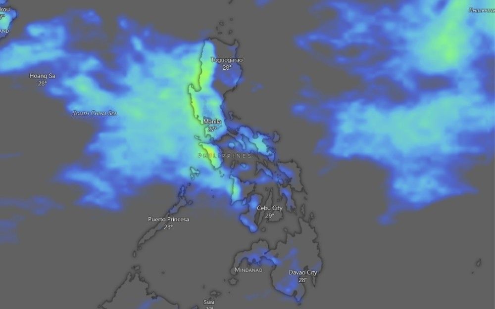
The Philippine Atmospheric, Geophysical and Astronomical Services Administration (PAGASA) forecasts heavy rains across parts of Luzon through the weekend due to the southwest monsoon. Zambales, Bataan, and Occidental Mindoro could see up to 200 millimeters of rain, increasing flood risks in Metro Manila and surrounding areas.
MANILA, Philippines — The Philippine Atmospheric, Geophysical and Astronomical Services Administration (PAGASA) has warned of heavy rains and heightened flood risks across parts of Luzon through the weekend, driven by the southwest monsoon. On Friday, between 100 to 200 millimeters of rain may drench Zambales, Bataan, and Occidental Mindoro. Waterways and low-lying communities in Metro Manila, Rizal, and Laguna remain at risk of flooding. State weather bureau PAGASA identified several rivers and tributaries in the Marikina-Laguna de Bay basin that may be affected by continued rainfall. These include the upper and lower Marikina River, Pasig River, San Juan River, the main Laguna de Bay basin, and tributaries in Metro Manila, Rizal, and Laguna. The bulletin also identified the Pagsanjan, Tanay, Morong, San Isidro, Biñan, and San Juan rivers, as well as tributaries in Rodriguez, Marikina, San Mateo, Antipolo, Quezon City, Pasig, Cainta, and Taytay. Road and street flooding may occur because of accumulated rainwater, poor or clogged drainage systems, and higher tide levels, PAGASA said. People living near mountain slopes and in low-lying areas were advised to remain alert for possible flash floods. Zambales, Bataan, and Occidental Mindoro may receive 100 to 200 mm of rain on Friday due to the southwest monsoon. PAGASA forecast 50 to 100 mm over Ilocos Sur, La Union, Pangasinan, Abra, Benguet, Tarlac, Pampanga, Bulacan, Metro Manila, Cavite, Batangas, and Antique. The heavy rain may persist through the weekend. On Saturday, 100 to 200 mm may fall over Ilocos Sur, La Union, Abra, Benguet, Zambales, Bataan, and Occidental Mindoro. Ilocos Norte, Pangasinan, Apayao, Kalinga, Mountain Province, Ifugao, Nueva Vizcaya, Tarlac, Nueva Ecija, Pampanga, Bulacan, Metro Manila, Cavite, and Batangas may receive 50 to 100 mm. By Sunday, Ilocos Sur, La Union, Abra, Benguet, and Zambales may still receive 100 to 200 mm. Rainfall of 50 to 100 mm may affect Ilocos Norte, Pangasinan, Apayao, Kalinga, Mountain Province, Ifugao, Nueva Vizcaya, Tarlac, Nueva Ecija, Bataan, Pampanga, and Occidental Mindoro. PAGASA warned that rainfall may be higher in mountainous and elevated areas. Flood and landslide impacts may also be worsened by rain that has already saturated the ground. Maymay had weakened into a low-pressure area and was located 565 kilometers east of Echague, Isabela, as of 3 a.m. Friday. Despite Maymay's weakening, the southwest monsoon continued to affect Central and Southern Luzon and the western portion of the Visayas. Monsoon rain may affect Occidental Mindoro, where moderate to heavy and at times intense rainfall could trigger flash floods or landslides. Occasional rain was forecast over Metro Manila, Pangasinan, La Union, Benguet, Zambales, Bataan, Tarlac, Pampanga, Bulacan, Rizal, Cavite, Batangas, Laguna, and Antique. The rest of Luzon and Western Visayas may experience scattered rain and thunderstorms due to the southwest monsoon. Typhoon Dolphin remained outside the Philippine area of responsibility, about 1,095 kilometers northeast of extreme Northern Luzon as of 3 a.m. It had maximum sustained winds of 140 kph near the center, gusts of up to 170 kph, and was moving west-northwestward at 20 kph. Its trough may bring scattered rain and thunderstorms to Batanes and the Babuyan Islands, with possible flash floods or landslides during moderate to at times heavy rain. The rest of the country may experience isolated rain showers or thunderstorms, which could trigger localized flooding or landslides during severe thunderstorms.
Original source
Philstar Nation