Typhoon Maysak Nears Northern Vietnam Coast
Typhoon Maysak is approaching the northern Vietnamese coast, particularly Quảng Ninh and Hải Phòng provinces, with maximum sustained winds of 88 km/h. Widespread heavy rainfall and high seas are expected, prompting urgent warnings.
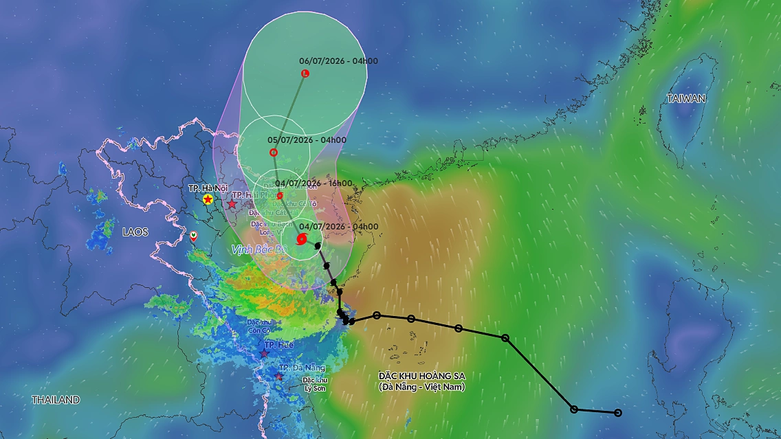
Northern Vietnam, particularly the coastal areas of Quảng Ninh and Hải Phòng provinces, is on high alert as Typhoon Maysak approaches. As of 6 AM local time on July 4, the storm's eye was located approximately 80 km southeast of Bạch Long Vĩ Island in Hải Phòng and 180 km east-southeast of Móng Cái City in Quảng Ninh. The typhoon carries maximum sustained winds of 88 km/h (Category 8-9), with gusts reaching up to 118 km/h (Category 11). The typhoon is forecast to maintain its northwest trajectory and make landfall on the coast of Quảng Ninh province around 4 PM today, with its intensity largely unchanged. It is then expected to move into southern Guangxi, China, where it will weaken into a tropical depression and subsequently a low-pressure area. In response, the Gulf of Tonkin is experiencing strong winds ranging from Category 6-7, intensifying to Category 8-9 near the storm's core, with waves reaching 2-4 meters. This poses a significant risk of capsizing or damage to fishing vessels, cargo ships, and tourist boats, as well as impacting fisheries, maritime transport, aquaculture, and coastal infrastructure. Coastal regions of Quảng Ninh, Hải Phòng, and Hưng Yên provinces are bracing for gale-force winds from Category 6 to Category 7-8, with gusts up to Category 9-10, from noon to afternoon today. The combination of high waves and a storm surge of 0.2-0.4 meters could lead to localized flooding in estuaries and low-lying coastal areas, affecting dykes, seawalls, transportation networks, and coastal structures. Furthermore, the typhoon's outer bands are expected to bring widespread heavy rainfall to the northeastern provinces and Thanh Hóa province from this morning through July 5. Rainfall totals are projected to range from 100-200 mm, with localized amounts exceeding 200-300 mm in the northeast, and potentially over 500 mm in some areas. This heavy precipitation increases the risk of urban flooding, industrial zone inundation, and low-lying area flooding. It also heightens the danger of flash floods on small rivers and streams, and landslides in mountainous regions. Meteorological agencies are also warning of thunderstorms, squalls, and strong gusts associated with the typhoon's approach. Residents in Quảng Ninh, Hải Phòng, Hưng Yên, and other northeastern provinces are urged to closely monitor the storm's developments and implement necessary preventative measures. The National Steering Committee for Natural Disaster Prevention and Control, along with the Ministry of Agriculture and Rural Development, has issued directives to northeastern provinces and Thanh Hóa to account for all vessels, assess areas vulnerable to flooding and landslides, and prepare for potential evacuations. Yesterday, authorities provided information and guidance to over 56,200 vessels and nearly 250,000 workers to seek safe harbor. Quảng Ninh, Hải Phòng, and Ninh Bình have already imposed sea bans. Information Source: VnExpress
多角的分析
台風メーサークの接近は、ベトナム北東部の経済活動に直接的な影響を与える。特に、沿岸部の漁業、海上輸送、養殖業は、強風と高波により操業停止や設備被害のリスクに直面する。また、大雨によるインフラ(道路、電力供給)への被害は、物流の遅延や産業活動の一時停止を招き、地域経済の損失につながる可能性がある。復旧には一定のコストと時間を要すると考えられる。
投資家にとって、この台風は短期的なリスク要因となる。特に、クアンニン省やハイフォン市に拠点を置く製造業や物流関連企業は、サプライチェーンの寸断や操業停止による生産性の低下、インフラ被害による復旧コストの増加に直面する可能性がある。長期的な視点では、気候変動による自然災害の頻度・強度増加は、ベトナム北部沿岸部のインフラ投資や事業継続計画の見直しを促す要因となりうる。
台風メーサークは、クアンニン省やハイフォン市沿岸部の住民の生活に直接的な脅威をもたらす。強風、高波、そして内陸部での大雨による浸水や土砂災害のリスクは、家屋の損壊、避難生活、そして生計手段の喪失につながりうる。特に、低地の住民や漁業従事者は、直接的な影響を受けやすく、事前の避難や安全確保が極めて重要となる。また、インフラ被害は、地域住民の移動や情報アクセスを困難にする可能性がある。
沿岸部の住民、特に漁業に依存する人々は、船の安全確保や家屋の補強に追われている。内陸部では、大雨による浸水被害への懸念が高まっている。政府による避難指示や情報提供が、住民の生命と財産を守る上で不可欠となる。過去の台風被害の経験から、迅速な避難行動が求められる。
背景・歴史的文脈
ベトナムは、南シナ海に面した長い海岸線を持つため、台風の直撃を受けやすい国である。特に北部沿岸は、毎年のように台風や熱帯低気圧の影響を受け、甚大な被害が発生してきた。過去には、2020年10月に台風コニ(Molave)が中部を襲い、多数の死者と大規模なインフラ被害をもたらした。政府は、災害対策基本法に基づき、早期警報システム、避難計画、インフラ整備(堤防、ダムなど)に力を入れているが、気候変動による台風の強度増加や頻度上昇は、これらの対策を常に強化する必要性に迫っている。
原文ソース
VnExpress