General articles are free for 24 hours after publish.
ITCZ Drenches Visayas, Mindanao; Tropical Depression Monitored Outside PAR
The Philippine Atmospheric, Geophysical and Astronomical Services Administration (PAGASA) warned of increased risks of flooding and landslides in the Visayas and Mindanao due to the Intertropical Convergence Zone (ITCZ). A tropical depression is also being monitored outside the Philippine Area of Responsibility (PAR).
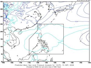
Thunderstorms are expected over the Visayas and Mindanao in the next 24 hours due to the effects of the Intertropical Convergence Zone (ITCZ), raising the risk of flooding and landslides, while a tropical depression is still being monitored outside the Philippine Area of Responsibility (PAR), the state weather bureau said on Tuesday. The ITCZ is a band of clouds where winds from the Northern and Southern Hemispheres meet, according to the Philippine Atmospheric, Geophysical and Astronomical Services Administration (PAGASA) during its 5:00 p.m. press briefing. “When two different air masses converge, this results in the formation of clouds and rainfall. At present, the ITCZ is bringing rains to a large part of the Visayas and Mindanao,” Benison Jay Estareja, PAGASA weather specialist, said in Filipino during the briefing. Scattered rains and thunderstorms induced by the ITCZ are expected over the Negros Island Region, Central Visayas, Eastern Visayas, Zamboanga Peninsula, Northern Mindanao, CARAGA, Masbate, Lanao del Sur and Davao Oriental in the next 24 hours, PAGASA said. It is likewise expected to affect the rest of the Visayas and Mindanao. Localized thunderstorms are expected to affect Metro Manila and the rest of Luzon. “So, let us be careful of sudden downpours that can cause flooding, especially in low-lying areas, while landslides are possible in mountainous areas,” Mr. Estareja said. Meanwhile, PAGASA is still monitoring a tropical depression outside the PAR that was located 2,785 kilometers east of Southeastern Luzon. It was packing maximum sustained winds of 55 kilometers per hour (kph) and gustiness of 70 kph. Mr. Estareja said the tropical depression is not affecting the country and that PAGASA is not ruling out the possibility that it may enter the PAR between Friday and Saturday. If it enters the PAR, it will be named Queenie, the country’s 17th tropical cyclone this year. — Edg Adrian A. Eva
Original source
BusinessWorld Nation