Super Typhoon Inday Triggers Signal No. 1 in Northeastern Cagayan
Environment
2026年7月8日
4
Inquirer NewsInfo

Super Typhoon Inday Triggers Signal No. 1 in Northeastern Cagayan

AI サマリー

Tropical Cyclone Warning Signal No. 1 has been raised in parts of northeastern Cagayan as Super Typhoon Inday (international name: Bavi) approaches the Philippine area of responsibility (PAR). Packing maximum sustained winds of 185 km/h, Inday is not expected to make landfall but will bring strong winds and heavy rainfall to coastal areas.

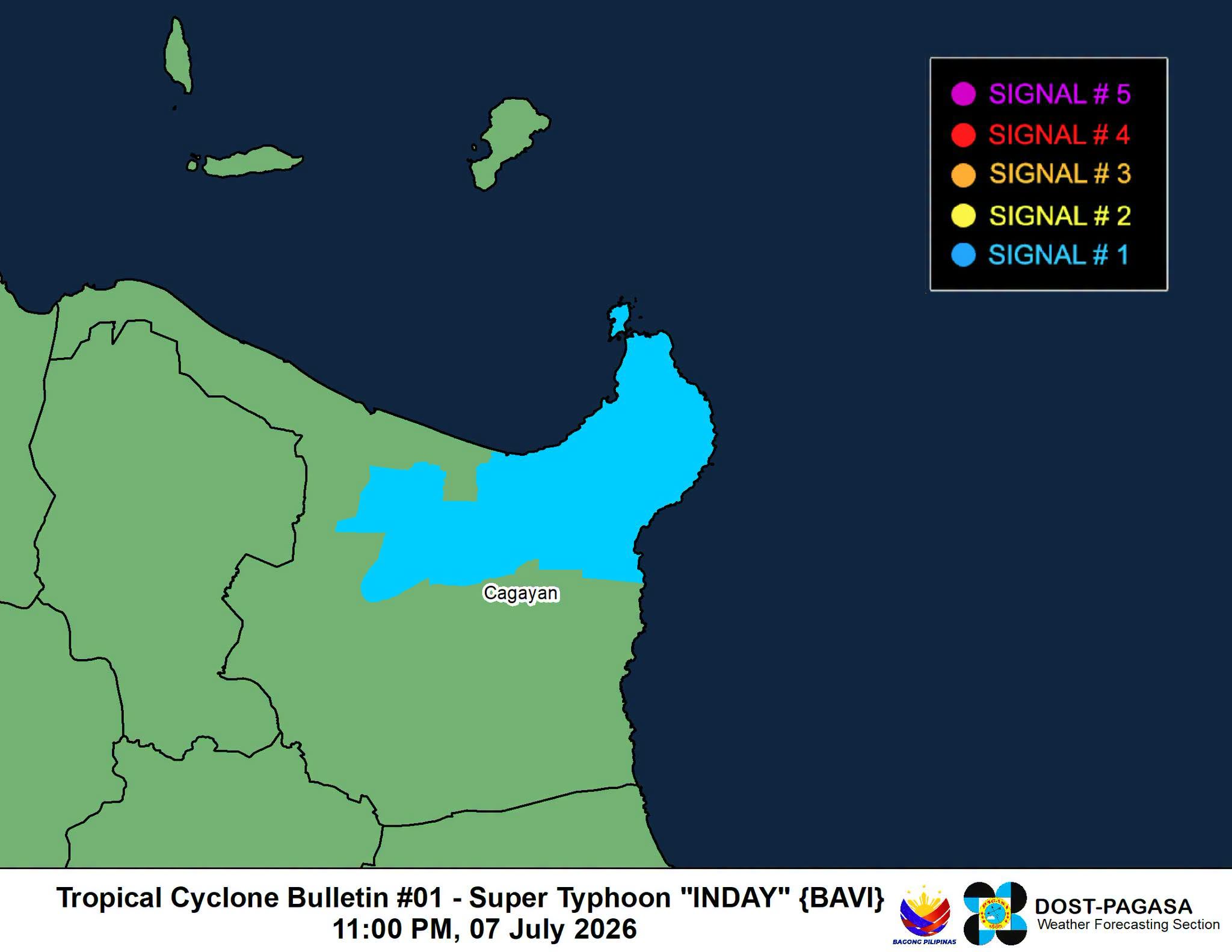
MANILA, Philippines — The weather bureau raised Tropical Cyclone Warning Signal No. 1 in several areas of Cagayan province as Super Typhoon Inday (international name: Bavi) is expected to enter the Philippine area of responsibility (PAR) on Wednesday morning. In a bulletin issued by the Philippine Atmospheric, Geophysical and Astronomical Services Administration (Pagasa) past 11 p.m. on Tuesday, it hoisted Signal No. 1 in towns in the northeastern portion of Cagayan, namely: Winds packing 39 to 61 kilometers per hour (km/h) are expected within 36 hours in areas under Signal No. 1. Houses of poor construction, old dilapidated structures, and other structures made of light materials will suffer minimal to minor damage. Rice crops, especially those in flowering and ripening stages, may suffer some damage. Pagasa warned that the highest wind signal that may be raised throughout Inday’s passage in PAR will be either Signal No. 2 or Signal No. 3. The enhanced southwest monsoon or “habagat” and the periphery of Inday will bring strong winds on Wednesday in Zambales, Bataan, Cavite, Batangas, most of Mimaropa, most of Bicol Region, most of Visayas, and most of Mindanao. By Thursday, most parts of the country will experience strong to gale-force gusts. Pagasa also warned of heavy rainfall (50 to 100 mm) due to Inday in Batanes from Thursday evening to Friday evening (July 9-10). Moderate to heavy rainfall (50-100 mm) advisory due to habagat is also raised from Wednesday to Thursday evening (July 8 to 9) Sultan Kudarat, Sarangani, Occidental Mindoro, Palawan, Antique, and Negros Occidental. For Thursday to Friday evening (July 9-10), heavy to intense (100-200 mm) rainfall will be experienced in Occidental Mindoro and Antique. Meanwhile, moderate to heavy (50-100 mm) will be expected in Zambales, Bataan, Metro Manila, Cavite, Batangas, Palawan, Guimaras, Iloilo, Negros Occidental, Negros Oriental, Lanao del Norte, and Lanao del Sur. READ: Evacuations ordered in preparation for Bavi As of 10 p.m., Pagasa said the center of the eye of Inday was estimated to be at 1,545 km east of northern Luzon, still outside of PAR. It slightly weakened as it came close to PAR, packing maximum sustained winds of 185 km/h near the center and gustiness of up to 230 km/h. It is moving westward at 30 km/h, and is forecast to enter PAR early on Wednesday. It will maintain its super typhoon strength and is projected to gradually weaken to a typhoon by Thursday as it moves east of extreme northern Luzon while continuing on a northwestward track. Despite remaining offshore, Inday is expected to pass close to Batanes on Friday before exiting the PAR on Saturday, heading towards the north of Taiwan. /cb

多角的分析

経済的影響

台風インディの接近は、フィリピン経済、特に農業部門に直接的な影響を与える可能性があります。レベル1警報が発令されたカガヤン州は、米やトウモロコシなどの主要農産物の生産地であり、開花期や成熟期の作物への被害は、供給不足や価格上昇につながる可能性があります。また、インフラへの被害は復旧コストを増加させ、経済活動を一時的に停滞させる要因となります。過去の台風被害からの復興途上にある地域では、経済的打撃はさらに深刻化するでしょう。

投資家心理

投資家にとって、台風インディの接近は短期的なリスク要因となります。農業関連企業や、被害を受ける可能性のあるインフラ(道路、港湾など)に投資している企業は、事業中断や資産価値の低下リスクに直面します。しかし、フィリピン経済は過去の自然災害への対応経験が豊富であり、インフラの強靭化やサプライチェーンの多様化が進めば、長期的な投資環境への影響は限定的と見られます。保険業界は、こうした自然災害を織り込んだリスク管理が求められます。

社会的影響

カガヤン州北東部の住民、特に脆弱なコミュニティに属する人々は、台風インディの直接的な影響を受けます。粗末な造りの家屋に住む人々は、強風による被害のリスクが高く、避難勧告が出された場合は迅速な対応が求められます。また、大雨による河川の増水や土砂災害の可能性も懸念され、地域住民の安全確保が最優先課題となります。過去の台風被害では、避難所の衛生状態や食料供給、医療支援などが課題となっており、今回も同様の支援体制が重要となります。

市民の声

カガヤン州北東部の住民は、台風インディの接近により、自宅の被害や農作物への影響を懸念しています。特に、脆弱な家屋に住む人々は、避難の必要性に直面する可能性があります。また、台風による交通網の寸断や停電は、日常生活に支障をきたす恐れがあります。過去の経験から、住民は食料や水の備蓄、非常用品の準備を進めていると考えられます。政府や地方自治体による早期の避難勧告や支援物資の配布が、住民の安全と生活再建に不可欠です。

背景・歴史的文脈

フィリピンは、太平洋の「火山の輪」と台風銀座に位置するため、自然災害、特に台風の襲来に脆弱な国です。年間平均20個以上の台風がフィリピンを通過し、そのうち数個は超大型(Super Typhoon)に発達します。これらの台風は、しばしば甚大な被害をもたらし、経済、インフラ、そして人々の生活に深刻な影響を与えてきました。特に、2013年の台風ヨランダ(ハイエン)は、フィリピン史上最悪の自然災害の一つとなり、その後の防災対策強化の契機となりました。政府は、Pagasaの早期警報システムや避難計画の改善、インフラの強靭化に努めていますが、気候変動による台風の強大化や頻度の変化が、さらなる課題となっています。

原文ソース

Inquirer NewsInfo

原文を読む