General articles are free for 24 hours after publish.
Northern Vietnam Braces for Floods, Landslides Amidst Record Rainfall
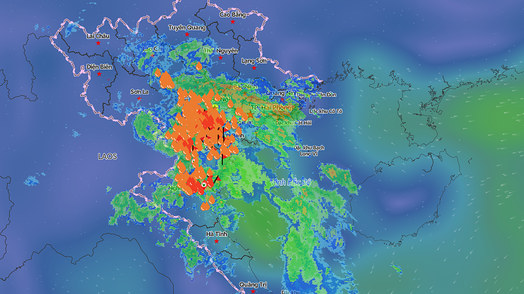
Record rainfall is expected to continue in northern and central coastal Vietnam until September 17, raising the risk of widespread flooding, flash floods, and landslides. Hanoi, Thanh Hoa, and Nghe An provinces are particularly vulnerable, with some areas anticipating over 250mm of precipitation, raising concerns for infrastructure.
Heavy rain is forecast to continue intermittently in northern and central coastal Vietnam until September 17, with some areas expected to receive over 250mm of precipitation. This raises the risk of widespread flooding, flash floods, and landslides. The National Center for Hydro-Meteorological Forecasting reports that Hanoi, Hung Yen, Ninh Binh, Thanh Hoa, Phu Tho, northern Nghe An, and southern Lao Cai will experience 70-170mm of rain on September 16-17, with localized amounts exceeding 250mm. Southern Son La, Tuyen Quang, Thai Nguyen, Hai Phong, Bac Ninh, and southern Nghe An are expected to receive 40-80mm, with some areas exceeding 150mm. Meteorological agencies warn of the potential for rainfall intensity exceeding 100mm within a three-hour period, which could cause flooding in low-lying areas and urban centers. The heavy rainfall is attributed to a combination of easterly to southeasterly winds and the influence of cold air. Between the evening of September 15 and the morning of September 16, northern and north-central regions recorded 50-100mm of rain. Nghia Khanh in Nghe An received 174mm, Tay Hieu 166mm, Tam Van in Thanh Hoa 148mm, and Cao Duong and Quy Hoa in Phu Tho recorded 127mm and 123mm respectively. From 7 PM on September 10 to 6 AM on September 16, rainfall in the midland and delta regions of the North ranged from 150-300mm. Areas from Ha Tinh to Quang Ngai recorded 150-400mm, with Quang Tri and Hue City experiencing 400-600mm. Some locations saw exceptionally high cumulative rainfall, including Ta Long in Quang Tri (896mm), La To (808mm), Dinh Bach Ma in Hue City (1,321mm), Nham (774mm), and Ta Luong (791mm). Prolonged rainfall has caused water levels to rise in many rivers across the North, Thanh Hoa, and Nghe An provinces. At 1 AM on September 16, the Boi River at Hung Thi station measured 12.93m, just 0.07m below alert level 3. The Buoi River at Thach Quang station reached 16.31m, 0.31m above alert level 3. The Yen River at Chuoi station peaked at 3.23m at 7 PM on September 15, 0.27m below alert level 3, before gradually receding. By 1 AM on September 16, the water level was 3.13m, 0.13m above alert level 2. In Ninh Binh, river levels continue to rise, generally above alert level 1 and approaching alert level 2. The Hoang Long River at Ben De station was at 3.45m, 0.05m below alert level 2, while the Day River at Phu Ly station was at 3.29m, 0.21m below alert level 2. Meteorological agencies predict that rivers in the North and Thanh Hoa will experience a flood wave on September 16. The peak of the Boi River could exceed alert level 3, while the Hoang Long River and smaller rivers in Thanh Hoa may reach alert levels 1-2, with some exceeding alert level 2. In the next six hours, Son La, Phu Tho, Lao Cai, Quang Ninh, Thanh Hoa, and Nghe An face a high risk of flash floods on small rivers and landslides on steep slopes. Disaster risk is rated Level 1, with Phu Tho specifically at Level 2.
Original source
VnExpress