Tropical Storm Threatens Vietnam's Northern Coast This Weekend
A tropical depression has formed off Vietnam's northern coast and is expected to develop into a storm and approach over the weekend. It is the first storm to form in Vietnamese waters this year, prompting calls for vigilance.
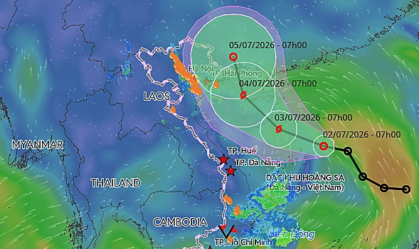
A tropical depression has formed off Vietnam's northern coast and is expected to intensify into a storm and approach over the weekend, according to the National Center for Hydro-Meteorological Forecasting. The system was located approximately 240 km east-northeast of the Hoang Sa (Paracel) Islands at 7:00 a.m. on Thursday. It was moving west-northwest at roughly 25 kph, with maximum sustained winds of 50-61 kph and gusts up to 75-88 kph. By 7:00 a.m. on Friday, the depression is forecast to intensify into a storm over the waters southeast of China's Hainan Island. Wind speeds are expected to reach 61-88 kph, with gusts hitting 103-133 kph. The storm, the first to form in Vietnam's waters this year, will continue its northwestern trajectory into the northern waters of the Gulf of Tonkin by Saturday morning, maintaining a sustained strength of 61-74 kph. International monitoring agencies, including the Japan Meteorological Agency and the Hong Kong Observatory, have provided similar forecasts, anticipating the system will intensify into a storm Thursday night before steering toward the Gulf of Tonkin. Under the influence of the developing storm, the northern East Sea, including the waters around the Hoang Sa Islands, will experience strong winds of 39-61 kph and waves ranging from two to four meters in height. Since the beginning of the year, one tropical depression has formed in the East Sea without affecting Vietnam. Weather officials forecast that between June and August, the region will see around five storms and tropical depressions. This aligns with historical multi-year averages, with up to two expected to directly impact the Vietnamese mainland. From September to December, the frequency of storms and tropical depressions is projected to fall below historical averages due to the influence of El Niño. Despite this projected decline in overall storm frequency, the meteorological agency warned that the risks of localized heavy rainfall, flash floods, and landslides remain high, posing a particular threat to the mountainous regions of northern and central Vietnam. In 2023, the East Sea recorded 21 storms and tropical depressions, marking the highest volume since record-keeping began in 1961. These natural disasters left 484 people dead or missing and caused over VND104.7 trillion (US$4 billion) in economic losses, making it one of Vietnam's costliest years on record for weather-related damage.
多角的分析
熱帯低気圧の接近は、ベトナム北部の漁業や農業に直接的な経済的影響を与える可能性がある。特に、漁船の出漁停止や収穫物の被害は、地域経済の停滞を招く。また、インフラへの被害が発生した場合、復旧には多額の費用がかかり、経済成長への足かせとなる。過去の事例(2023年の記録的な被害)からも、自然災害はベトナム経済にとって無視できないリスク要因であることが示されている。
投資家にとっては、短期的なサプライチェーンの混乱やインフラ被害による事業継続リスクが懸念される。特に、北部地域に生産拠点を置く製造業や、農業関連企業は注意が必要だ。しかし、長期的には、気象災害への対応能力強化やインフラ投資の必要性が高まることで、関連産業への投資機会も生まれる可能性がある。
熱帯低気圧の接近は、特に沿岸部や山岳地帯の住民の生活に直接的な脅威をもたらす。避難勧告やインフラの寸断は、人々の日常生活を混乱させ、安全確保が最優先課題となる。また、過去の災害では多くの人命が失われており、防災意識の向上と避難体制の強化が、社会全体で求められている。
ベトナム市民、特に北部沿岸部や山岳地帯に住む人々にとっては、生活への直接的な影響が懸念される。漁業や農業に依存する地域では、生計手段が失われるリスクがある。また、過去の災害で甚大な被害が出ていることから、防災への関心が高まり、自治体や政府の対応が注目されるだろう。都市部でも、インフラへの影響や食料供給への懸念が生じる可能性がある。
背景・歴史的文脈
ベトナムは、南シナ海(ベトナムでは東シナ海と呼称)に面しており、熱帯低気圧の発生・進路に影響を受けやすい地理的条件にある。特に、夏から秋にかけては、フィリピン沖で発生した熱帯低気圧が西進し、ベトナム沿岸に接近・上陸することが多い。過去、2023年には記録的な数の熱帯低気圧が発生し、甚大な被害をもたらした。これは、エルニーニョ現象などの気候変動の影響も指摘されており、ベトナム政府は防災・減災対策の強化を喫緊の課題としている。今回発生した熱帯低気圧は、今年初であり、今後の進路と発達状況が注視されている。
原文ソース
VnExpress International