General articles are free for 24 hours after publish.
Typhoon Saudel Affects Vietnam's Coastal Waters, Not Mainland
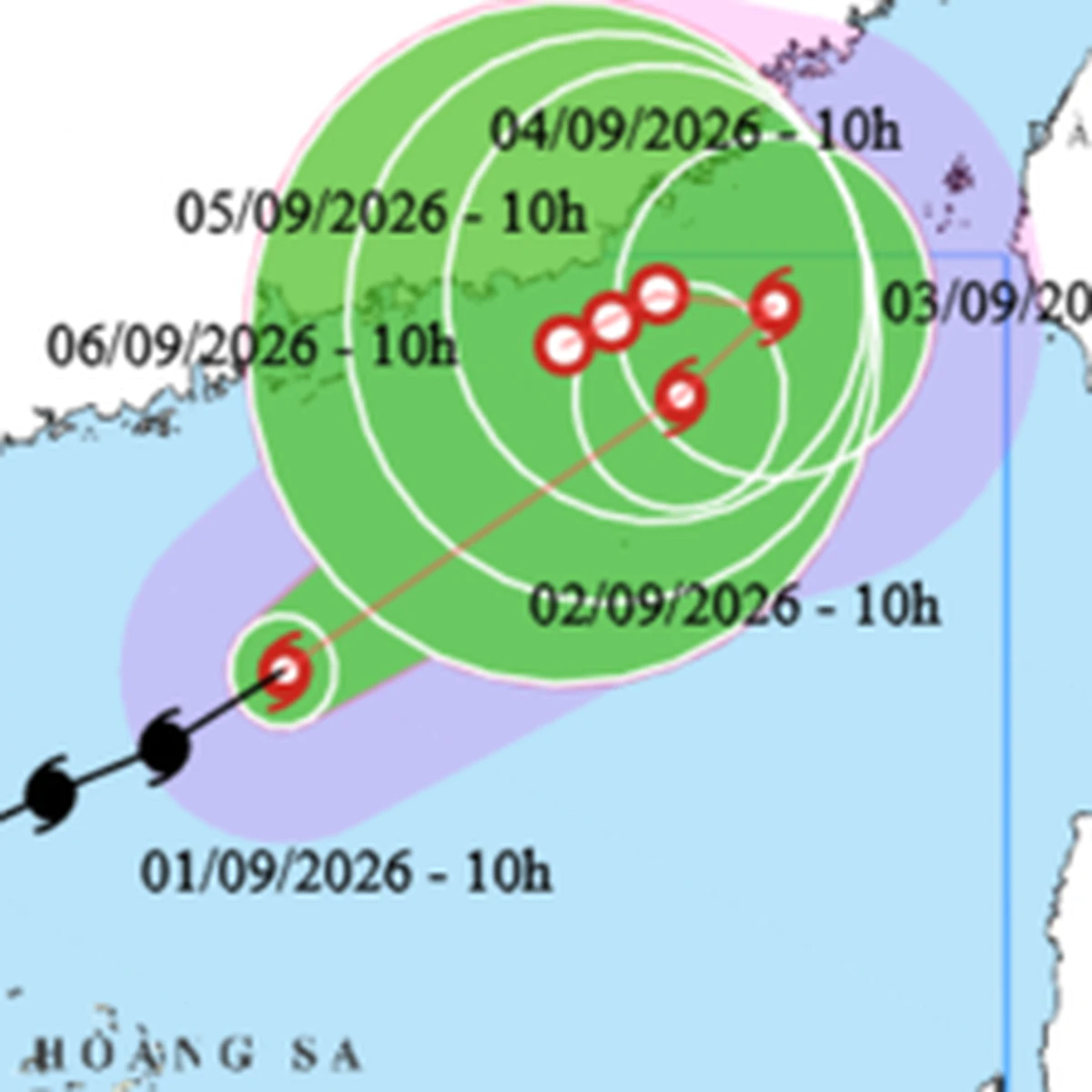
Tropical storm Saudel is forecast to move towards the Taiwan Strait, with no direct impact expected on mainland Vietnam. However, strong winds and high waves are anticipated in coastal waters, particularly in the northern Gulf of Tonkin.
Tropical storm Saudel is forecast to move towards the Taiwan Strait and gradually weaken, thus posing no direct threat to mainland Vietnam. However, strong winds and high waves are expected in several coastal areas, necessitating caution. According to the National Center for Hydro-Meteorological Forecasting, as of 10 AM on September 1st, the center of the storm was located in the northern part of the northern South China Sea (Bắc Biển Đông). The maximum wind speed near the eye of the storm was at level 8 (62-74 km/h), with gusts up to level 10. The storm is moving northeast at a considerable speed of about 20 km/h. "From today to September 4th, Saudel will move northeast, weaken, and move away from our waters, thus not affecting the Vietnamese mainland," the meteorological agency stated. Nevertheless, the combined effects of Tropical Storm Saudel, the intertropical convergence zone, and strong southwest monsoons will result in strong winds and high waves across many sea areas nationwide. Specifically, on the day and night of September 1st, the northern part of the northern South China Sea will experience winds of level 6-7, with gusts of level 8-9, and wave heights of 3-5 meters. Near the storm's eye, winds will reach level 8, with gusts up to level 10, and wave heights of 4-6 meters, indicating rough seas. In the southern Gulf of Tonkin, winds of level 6, with gusts up to level 8, and wave heights of 2-3 meters are expected. Winds are forecast to gradually decrease from tonight. The southern part of the northern South China Sea and the central South China Sea (including the Paracel Islands) will see winds of level 6, occasionally reaching level 7, with gusts up to level 8, and wave heights of 3-5 meters. Furthermore, the sea area from southern Quảng Trị to Ho Chi Minh City, and the northern part of the southern South China Sea (including the northern Spratly Islands), will experience winds of level 6, with gusts of level 7-8, and wave heights of 2-4 meters. Additionally, on September 1st, rain showers and thunderstorms are likely in many of the aforementioned sea areas. These thunderstorms may bring about tornadoes, strong gusts of level 7-8, and waves exceeding 2 meters. Strong winds and high waves are predicted to persist in these areas (except for the southern Gulf of Tonkin) on September 2nd. Ships operating in these dangerous zones are at risk of being affected by thunderstorms, tornadoes, strong winds, and high waves, requiring extreme caution. According to the meteorological agency, localized heatwaves were recorded in the northern region on August 31st, with maximum temperatures exceeding 35 degrees Celsius in some places. On September 1st, hot weather, with some areas experiencing intense heat, is forecast for the northern region (excluding Điện Biên, Lai Châu, and Sơn La provinces), with maximum temperatures generally ranging from 35-37 degrees Celsius, and over 37 degrees Celsius in some locations. On September 2nd, the heat in the north will ease, but hot weather will return to areas from Thanh Hóa to Đà Nẵng and eastern Quảng Ngãi province, with maximum temperatures generally between 35-37 degrees Celsius, and over 37 degrees Celsius in some places. Heatwaves in the central region are expected to continue until September 3rd or 4th. Tropical storm Saudel is projected to intensify into a typhoon around September 1st, while the northern region will experience a return to hot weather from the same day. Source: The Saigon Times
Original source
The Saigon Times