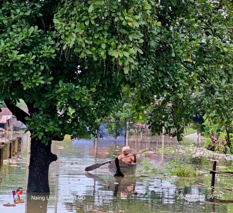
Phakant and some areas in Karen State are flooded, while water recedes in Rakhine
Environment
2026年7月13日
3
Mizzima (Burmese)

Phakant and some areas in Karen State are flooded, while water recedes in Rakhine

AI サマリー

Photo – A scene of flooding in Hlaingbwe Township, Kayin State, this morning. Heavy rains and rising river levels have caused flooding in Phakant, Kachin State, and some areas in Kayin State, while water levels are reced

Photo – A scene of flooding in Hlaingbwe Township, Kayin State, this morning. Heavy rains and rising river levels have caused flooding in Phakant, Kachin State, and some areas in Kayin State, while water levels are receding in Rakhine State, which had been experiencing floods for nearly a week, according to local residents. (Naing Linn Aung) YT, Yaung Ni (July 13) Mizzima. Heavy rains and rising river levels have caused flooding in Phakant, Kachin State, and some areas in Kayin State, while water levels are receding in Rakhine State, which had been experiencing floods for nearly a week, according to local residents. In Myawaddy town, Kayin State, on the Thai-Myanmar border, flooding has been occurring since July 12 due to rising water levels in the Thanlwin River. “The water has receded quite a bit this morning. It’s also because the rain has stopped. However, people have not been allowed to return yet. We have had to open more than 10 temporary shelters, including monasteries,” said an official from a social welfare organization in Myawaddy town. Similarly, in Bilin Township, four low-lying wards are flooded due to the influx of water from the Bilin River, and some villages have also been inundated, with up to nine flood relief camps having to be opened, according to local residents. In Hlaingbwe Township, where the Zami River has risen over 20 feet, residents of the low-lying Ward 6 and areas near the riverbank are being relocated, it is reported. “The rain is still falling. The water has risen quite a lot. Since it rained until this morning, the water is not expected to recede yet. Currently, the low-lying areas, mainly Ward 6, are being evacuated. We can no longer cross the bridge, and the ferries have also been stopped,” a local resident of Hlaingbwe Township told Mizzima this morning. In Phakant town, Kachin State, flooding has been occurring since July 12 due to heavy rains, mountain runoff, and rising water levels in the Uru River. Local residents of Phakant Township had also experienced flooding in June, and are now facing another wave of flooding. In Rakhine State, where flooding occurred due to heavy rains causing rivers to rise starting July 7, water levels have begun to recede since July 12, according to local residents. In Mrauk-U, Minbya, Kyauktaw, and Myebon townships, which experienced flooding, the water level has dropped by at least three feet since yesterday evening, and the main roads are no longer submerged. However, as the rain continues, most residents have not yet returned to their homes and are staying in safe places, continuing to monitor the flood situation. While water levels are receding in many flood-affected areas of Rakhine State, some villages in Gwa Township have started experiencing flooding since today, July 13, due to rainfall and mountain runoff, according to local news outlets. The Ministry of Social Welfare, Relief and Resettlement (MSLHA) of the National Unity Government (NUG) announced in its weekly weather forecast released today that the monsoon is expected to be strong until July 19, and a low-pressure area may form in the Bay of Bengal. The forecast advises that due to the influence of the low-pressure area and the monsoon, rain may continue across Myanmar, and special caution should be exercised for subsequent floods and landslides. The Meteorology and Hydrology Department under the military council also reissued a heavy rain warning this morning, stating that due to the active monsoon, rain may continue across Myanmar until July 20, with heavy rainfall possible in some areas. Rising river levels also continue, with the Chindwin River at Homalin, the Salween River at Mawlamyine, and the Sittoung River at Madauk exceeding their respective danger levels, and are expected to remain above danger levels for the next day, according to the Meteorology and Hydrology Department. The Ngawan River at Ngathinechaung town was measured at approximately half a foot below its danger level at 6:30 AM today and is expected to reach its danger level within the next 36 hours, according to the department. Meteorological and hydrological departments are urging those living near rivers and in low-lying areas to be cautious of flooding due to heavy rainfall and rising river levels across Myanmar. In addition to floods, the meteorological and hydrological departments are advising caution for travel and activities in flood-prone areas and areas where mountain runoff occurs, as secondary natural disasters such as strong winds and landslides are possible.

多角的分析

経済的影響

写真 – カレン州、カインセーギョー郡区で本日午前中に発生した洪水の様子。 大雨と河川水位の上昇により、カチン州のファカンとカレン州の一部で洪水が発生しており、約1週間にわたり洪水に見舞われていたラカイン州では水位が低下し始めていると地元住民が伝えています。この動きは直接の経済指標ではなくても、行政運営、地域の信頼、公共サービスの質を通じて企業活動や生活コストに波及する可能性があります。

投資家心理

投資家にとっては、個別ニュースの背後にある制度の安定性、情報公開、地域社会の反応が判断材料になります。短期の見出しだけでなく、継続的な変化を見る必要があります。

社会的影響

写真 – カレン州、カインセーギョー郡区で本日午前中に発生した洪水の様子。 大雨と河川水位の上昇により、カチン州のファカンとカレン州の一部で洪…という事実は、カレン州の住民にとって制度の発表ではなく、日々の判断材料になります。住民がどこまで説明し、洪水を抱える人に情報が届くかが社会的な焦点です。

市民の声

市民にとっては、このニュースが安全、雇用、教育、行政サービスなど身近な領域にどうつながるかが焦点です。生活者目線で具体的な影響を追う価値があります。

背景・歴史的文脈

Mizzima (Burmese)が伝えたこのニュースは、ミャンマーの行政運営や地域社会の変化を読むための小さなシグナルです。個別の発表や事件でも、制度、生活、対外関係のどこに影響するかを分けて見ることで、ニュースの意味が見えやすくなります。

原文ソース

Mizzima (Burmese)

原文を読む