General articles are free for 24 hours after publish.
Typhoon No. 5 Changes Course, May Linger in East Sea for Days; Northern Vietnam Endures Heatwave
Typhoon No. 5 (Saudel) is exhibiting erratic course changes in the East Sea, with projections indicating it may linger for several days. While direct landfall on Vietnam's mainland is unlikely, its circulation is contributing to a persistent heatwave in the northern regions.
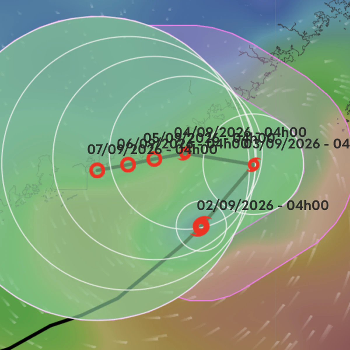
Typhoon No. 5 (Saudel) is exhibiting erratic course changes in the East Sea, with projections indicating it may linger for several days. The storm maintains its intensity at level 8 (62-74 km/h), with gusts up to level 10, and is expected to persist for multiple days over the East Sea. According to the National Center for Hydro-Meteorological Forecasting at 4 AM on September 2nd, the typhoon's center is located in the northeastern part of the northern East Sea. The latest meteorological forecasts suggest that Typhoon No. 5 will maintain its level 8 intensity until approximately September 4th, after which it may gradually weaken. Regarding the typhoon's path, it is trending towards slower movement and continuous course changes, and is predicted to exist for many days. It is highly probable that the typhoon will remain over the East Sea for the next four days, without making landfall. Specifically, for the day and night of September 2nd, the typhoon is expected to move northeastward at a speed of about 5-10 km/h. By 4 AM on September 3rd, the typhoon's center will be in the northeastern part of the northern East Sea, maintaining its intensity at level 8 with gusts of level 10. During the day and night of September 3rd, the typhoon will change direction, moving west-northwestward at approximately 5 km/h. By 4 AM on September 4th, in the southeastern waters of Guangdong province, China, the typhoon's intensity will remain strong at level 8, with gusts of level 10. During the day and night of September 4th, Typhoon No. 5 will move west-southwestward at a speed of about 3 km/h and has the potential to weaken into a tropical depression. By 4 AM on September 5th, the center of the tropical depression will be in the southeastern waters of Guangdong province, with an intensity of level 7 (50-61 km/h) and gusts of level 9. Subsequently, the tropical depression will move west-southwestward at approximately 3 km/h, with gradually weakening intensity. Due to the influence of the typhoon, the northeastern waters of the northern East Sea will experience strong winds of level 6-7, with gusts of level 8-9, and sea waves of 3-5 meters. In areas near the typhoon's center, winds will reach level 8, with gusts of level 10, and sea waves of 4-6 meters, resulting in rough seas. Ships operating in the aforementioned dangerous areas are likely to be affected by squalls, tornadoes, strong winds, and large waves. Northern Vietnam Continues to Experience Heatwave Although Typhoon No. 5 is not expected to make landfall in Vietnam, its western circulation is causing a divergent field with dry northerly winds, leading to widespread heatwave conditions in the North. The heatwave is predicted to continue in the North today (September 2nd) and tomorrow. From today, the heatwave will expand to the North Central region, followed by the Central Central region. Specifically, on September 2nd, the Northern region and the area from Thanh Hoa to northern Quang Tri province will experience heatwaves, with some areas facing severe heat, with maximum temperatures generally ranging from 35-37 degrees Celsius, and in some places exceeding 37 degrees. On September 3rd, the region from Thanh Hoa to Da Nang and eastern Quang Ngai province will experience heatwaves, with some areas facing severe heat, with maximum temperatures generally ranging from 35-37 degrees Celsius, and in some places exceeding 37 degrees. Typhoon No. 5 (Saudel) is forecast to move towards the Taiwan Strait and gradually weaken, thus not affecting mainland Vietnam. However, many sea areas will experience strong winds and high waves. Information Source: The Saigon Times
Original source
The Saigon Times