Tropical Depression Maymay exits Luzon; monsoon rains to persist
Environment
2026年8月6日
5
Rappler Philippines

General articles are free for 24 hours after publish.

Tropical Depression Maymay exits Luzon; monsoon rains to persist

Share
AI Summary

Tropical Depression Maymay has exited Luzon and is now over the Philippine Sea. While it has weakened, the southwest monsoon will continue to bring rain to various parts of the Philippines, with coastal areas warned of high waves.

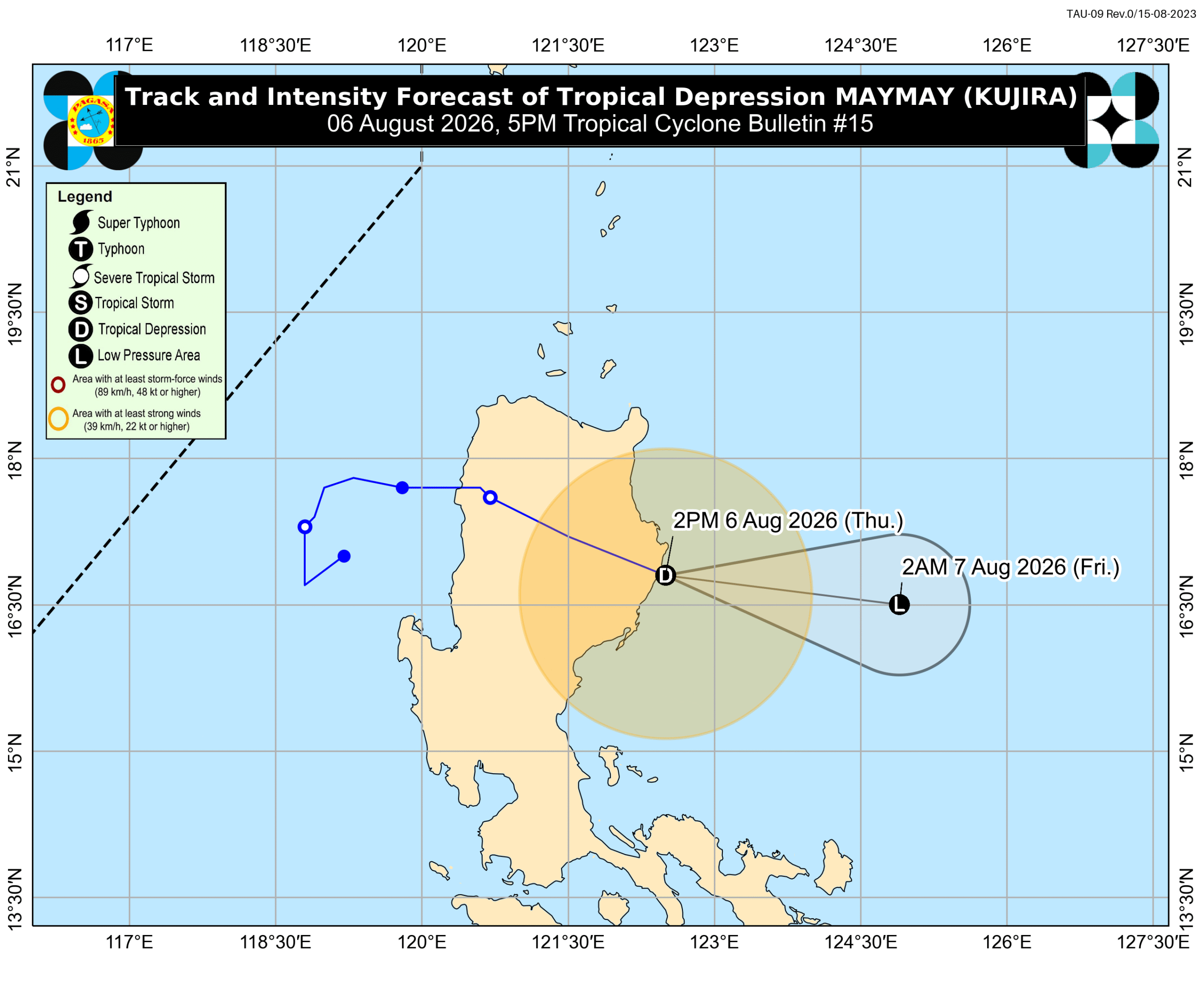
MANILA, Philippines – Tropical Depression Maymay (international name Kujira) finished crossing Northern Luzon and was already over the Philippine Sea on Thursday afternoon, August 6. As of 4 pm on Thursday, Maymay was located 150 kilometers east northeast of Echague, Isabela, moving east southeast at a much faster 35 kilometers per hour (km/h). The tropical depression had further weakened early Thursday afternoon, with its maximum sustained winds down to 45 km/h. Its gustiness is currently up to 70 km/h. At its peak, Maymay was a tropical storm with maximum sustained winds of 75 km/h. It made landfall at this intensity at 2 am on Thursday, in Magsingal, Ilocos Sur. The Philippine Atmospheric, Geophysical, and Astronomical Services Administration (PAGASA) said in its 5 pm bulletin that Maymay could weaken into a remnant low on Thursday evening or early Friday morning, August 7. Afterwards, the remnant low may move generally southeast until it merges with Typhoon Dolphin, the tropical cyclone still outside the Philippine Area of Responsibility (PAR). Following Maymay’s exit from landmass, rain has also begun easing in Northern Luzon. But based on PAGASA’s updated rainfall advisory at 5 pm on Thursday, moderate to heavy rain (50-100 millimeters) may still hit Ilocos Sur, La Union, Pangasinan, and Benguet within 24 hours. Floods and landslides can still occur. The more dominant rain-bearing system now is the southwest monsoon or habagat, which will continue to affect Southern Luzon and Central Luzon in the next 24 hours, before also eventually affecting Northern Luzon. The affected areas must remain on alert for floods and landslides. Thursday afternoon, August 6, to Friday afternoon, August 7 Heavy to intense rain (100-200 mm): Occidental Mindoro Moderate to heavy rain (50-100 mm): Zambales, Bataan, Tarlac, Pampanga, Bulacan, Metro Manila, Rizal, Cavite, Laguna, Batangas Friday afternoon, August 7, to Saturday afternoon, August 8 Heavy to intense rain (100-200 mm): Zambales, Bataan, Occidental Mindoro Moderate to heavy rain (50-100 mm): Ilocos Sur, La Union, Pangasinan, Abra, Benguet, Tarlac, Pampanga, Metro Manila, Cavite, Batangas, Antique Saturday afternoon, August 8, to Sunday afternoon, August 9 Heavy to intense rain (100-200 mm): Ilocos Sur, La Union, Abra, Benguet, Zambales Moderate to heavy rain (50-100 mm): Ilocos Norte, Pangasinan, Apayao, Kalinga, Mountain Province, Ifugao, Nueva Vizcaya, Tarlac, Nueva Ecija, Bataan, Pampanga, Occidental Mindoro Meanwhile, strong winds from Maymay are still reaching portions of Northern Luzon. These areas are under Signal No. 1 as of 5 pm on Thursday: southeastern part of mainland Cagayan (Tuao, Piat, Enrile, Alcala, Amulung, Baggao, Solana, Tuguegarao City, Gattaran, Peñablanca, Iguig) Isabela Quirino northeastern part of Nueva Vizcaya (Dupax del Norte, Kasibu, Quezon, Bagabag, Diadi, Bayombong, Ambaguio, Villaverde, Bambang, Solano, Alfonso Castañeda, Dupax del Sur) northern and central parts of Aurora (Dilasag, Casiguran, Dinalungan, Dipaculao) eastern part of Kalinga (Tabuk City, Pinukpuk, Tanudan, Lubuagan, Rizal) eastern part of Mountain Province (Paracelis, Natonin, Barlig) eastern part of Ifugao (Lagawe, Aguinaldo, Asipulo, Hingyon, Kiangan, Lamut, Alfonso Lista, Mayoyao, Banaue) The southwest monsoon and Maymay’s periphery or outer bands also continue to bring strong to gale-force gusts to most of the country. For coastal waters, here are the latest conditions in seaboards affected by the tropical depression and the southwest monsoon: Up to very rough seas (travel is risky for all vessels) Seaboard of Batanes – waves up to 4.5 meters high Up to rough seas (small vessels should not venture out to sea) Seaboard of Babuyan Islands; northeastern seaboard of mainland Cagayan – waves up to 4 meters high Eastern seaboard of Davao Oriental – waves up to 3.5 meters high Seaboards of Isabela and northeastern Aurora; northern seaboards of Ilocos Norte, Camarines Norte, and Camarines Sur; northern and eastern seaboards of Polillo Islands, Catanduanes, and Northern Samar; remaining seaboard of mainland Cagayan – waves up to 3 meters high Up to moderate seas (small vessels should take precautionary measures or avoid sailing, if possible) Seaboards of Zambales, Lubang Islands, Kalayaan Islands, and Surigao del Sur; western seaboards of Pangasinan, Bataan, Cavite, Batangas, Occidental Mindoro, Calamian Islands, and northern mainland Palawan; eastern seaboards of Albay, Sorsogon, Eastern Samar, Dinagat Islands, and Siargao-Bucas Grande Islands; remaining seaboards of Aurora and Camarines Norte – waves up to 2.5 meters high Seaboards of Ilocos Sur, La Union, Romblon, Masbate, Cuyo Islands, Cagayancillo Islands, Antique including Caluya Islands, Davao de Oro, Davao del Norte, Davao City, Davao del Sur, and Davao Occidental; western seaboards of mainland Palawan and Negros Occidental; southern seaboards of Quezon, Marinduque, Iloilo, Guimaras, and Negros Oriental; remaining seaboards of Ilocos Norte, Pangasinan, Batangas, Occidental Mindoro, Camarines Sur, Catanduanes, Albay, Sorsogon, Northern Samar, and Davao Oriental – waves up to 2 meters high Maymay is the Philippines’ 13th tropical cyclone for 2026, and the second for August, coming shortly after Tropical Depression Luis. As for Dolphin, it was last spotted 1,240 kilometers east northeast of extreme Northern Luzon at 4 pm on Thursday, moving west northwest at 20 km/h. The typhoon still has maximum sustained winds of 150 km/h and gustiness of up to 185 km/h. At its peak, Dolphin was a super typhoon. Dolphin may or may not enter PAR, but it will be enhancing the southwest monsoon. If it enters, it would be given the local name Neneng. PAGASA earlier said two to four tropical cyclones could develop within or enter PAR in August. – Rappler.com

0

Original source

Rappler Philippines

原文を読む