General articles are free for 24 hours after publish.
PAGASA Monitors 3 Tropical Depressions, 1 LPA Amidst Southwest Monsoon Rains
The Philippine Atmospheric, Geophysical, and Astronomical Services Administration (PAGASA) is monitoring three tropical depressions and one low-pressure area (LPA) as the southwest monsoon continues to bring rains over Luzon and the Visayas, raising concerns of flooding and landslides in some areas.
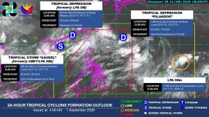
Three tropical depressions and one low-pressure area (LPA) are being monitored as the southwest monsoon continues to bring rains over Luzon and the Visayas, posing a risk of flooding and landslides in some areas, according to the state weather bureau on Tuesday. Tropical Depression Pilandok remains inside the Philippine Area of Responsibility (PAR), located 1,050 kilometers east of Extreme Northern Luzon, according to the Philippine Atmospheric, Geophysical, and Astronomical Services Administration (PAGASA) during its 5:00 a.m. press briefing. Pilandok has maintained its intensity, with maximum sustained winds of 55 kilometers per hour (kph) and gustiness of up to 70 kph. “Tropical Depression Pilandok has no direct effect on any part of the country and has a very low chance of making landfall in any part of the country,” PAGASA weather specialist Veronica C. Torres said during the press briefing in Filipino. She also said Pilandok is likely to intensify into a tropical storm within the next 12 hours and will exit PAR between Wednesday evening and Thursday morning. PAGASA is also monitoring Tropical Storm Saudel, formerly known as Obet, located 965 kilometers west of Extreme Northern Luzon. It was packing maximum sustained winds of 65 kph and gustiness of up to 80 kph. Ms. Torres said the bureau is not ruling out the possibility that Saudel may re-enter PAR, in which case it will still be called Obet. The third tropical depression being monitored was located 645 kilometers west-northwest of Itbayat, Batanes, packing maximum sustained winds of 45 kph and gustiness of up to 60 kph. PAGASA is also monitoring an LPA outside PAR, located 3,000 kilometers east of Southeastern Luzon. It has a chance of developing into a tropical depression within the next 12 hours and may enter PAR. Meanwhile, the southwest monsoon is expected to continue bringing rains over Luzon and the western section of the Visayas. Heavy rainfall, or rainfall of between 50 and 100 millimeters, is expected in Ilocos Norte, Ilocos Sur, La Union, Pangasinan, Batanes, Abra, Benguet, Zambales, and Bataan. PAGASA warned of possible localized flooding and landslides, particularly in urban and near-river areas. More areas are expected to be placed under rainfall warnings, with intense rainfall possible in some areas until Thursday. — Edg Adrian A. Eva
Original source
BusinessWorld Nation