Typhoon Inday downgraded to typhoon over Philippine Sea, bringing heavy rain, rough seas
Typhoon Inday has been downgraded to a typhoon as it moves over the Philippine Sea, but is forecast to bring moderate to heavy rains to Northern Luzon by Friday. The enhanced southwest monsoon will also cause scattered rains and thunderstorms across the country, with rough seas expected.
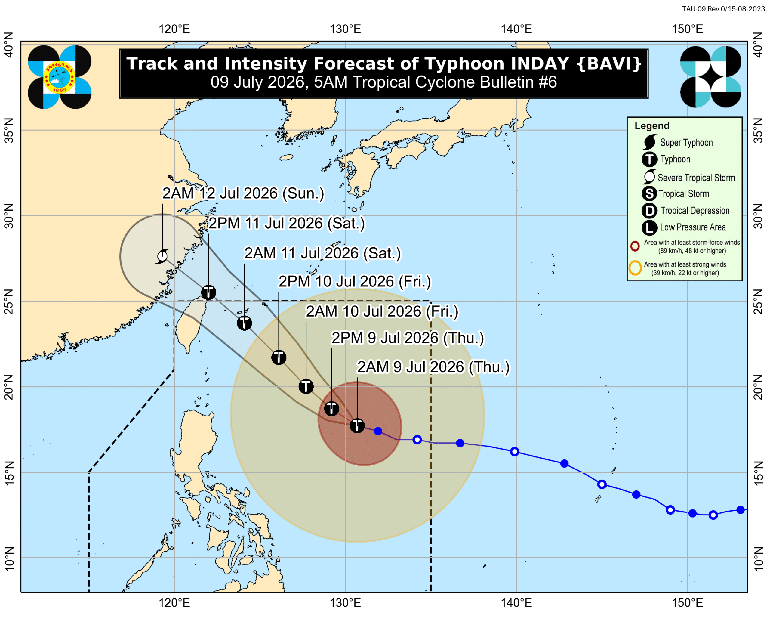
MANILA, Philippines – Inday (Bavi) was downgraded from a super typhoon to a typhoon before dawn on Thursday, July 9, as it continued moving over the Philippine Sea. Inday’s maximum sustained winds are down to 175 kilometers per hour, said the Philippine Atmospheric, Geophysical, and Astronomical Services Administration (PAGASA) in a bulletin issued at 5 am on Thursday. Its gustiness eased to up to 215 km/h. The typhoon was located 925 kilometers east of Northern Luzon at 4 am, moving west northwest at 20 km/h. It may be nearest to extreme Northern Luzon by Friday evening, July 10, or Saturday morning, July 11, before heading toward Japan’s southern islands and passing close to or making landfall in Taiwan’s northern coast. The Philippines’ northernmost province of Batanes is likely to have moderate to heavy rain (50-100 millimeters) due to Inday on Friday. But even before then, Inday may already trigger rain with gusty winds in Cagayan Valley, the Cordillera Administrative Region, Ilocos Norte, Aurora, and Catanduanes on Thursday. The rest of Bicol as well as Eastern Visayas may have scattered rain and thunderstorms due to the typhoon, too. Also on Thursday, the enhanced southwest monsoon or habagat could bring scattered rain and thunderstorms to Mimaropa, Western Visayas, the Negros Island Region, Zamboanga Peninsula, Bangsamoro Autonomous Region in Muslim Mindanao, Lanao del Norte, Sultan Kudarat, Sarangani, and South Cotabato. The rest of Mindanao as well as Central Visayas may also see isolated rain showers or thunderstorms from the southwest monsoon. For the next three days, rain due to the southwest monsoon might be heaviest in the following areas: Thursday, July 9 Moderate to heavy rain (50-100 mm): Occidental Mindoro, Antique, Negros Occidental Friday, July 10 Heavy to intense rain (100-200 mm): Occidental Mindoro, Antique Moderate to heavy rain (50-100 mm): Zambales, Bataan, Palawan, Iloilo, Guimaras, Negros Occidental, Negros Oriental, Zamboanga del Sur, Lanao del Norte, Lanao del Sur Saturday, July 11 Moderate to heavy rain (50-100 mm): Pangasinan, La Union, Zambales, Bataan, Pampanga, Bulacan, Metro Manila, Rizal, Cavite, Batangas, Oriental Mindoro, Romblon, Palawan, Aklan, Capiz, Iloilo, Guimaras, Negros Occidental, Negros Oriental Floods and landslides are likely. Meanwhile, Signal No. 1 is raised in these areas as of 5 am on Thursday, with Inday bringing strong winds: Batanes Cagayan including Babuyan Islands Isabela northeastern part of Quirino (Maddela) Apayao northern part of Abra (Tineg, Lagayan, Danglas, San Juan, Lagangilang, Licuan-Baay, Malibcong, Lacub, Daguioman, Dolores, La Paz) Kalinga eastern part of Mountain Province (Natonin, Paracelis) eastern part of Ifugao (Aguinaldo, Alfonso Lista) Ilocos Norte northern part of Aurora (Dilasag, Casiguran) northern and central parts of Catanduanes (Pandan, Caramoran, Bagamanoc, Panganiban, Viga, Gigmoto, Baras, San Miguel) The highest possible tropical cyclone wind signal due to Inday could be Signal No. 2. The enhanced southwest monsoon and the periphery or outer bands of the typhoon are also bringing strong to gale-force gusts to most of the country from Friday to Saturday. In addition, conditions at sea are worsening on Thursday. Up to very rough seas (travel is risky for all vessels) Seaboards of Batanes; northern and eastern seaboards of Babuyan Islands; northeastern seaboard of mainland Cagayan – waves up to 6 meters high Remaining seaboards of mainland Cagayan and Babuyan Islands; seaboard of Isabela – waves up to 5 meters high Seaboards of Aurora and Camarines Norte; northern seaboard of Camarines Sur; northern and eastern seaboards of Polillo Islands and Catanduanes; eastern seaboard of Northern Samar; northeastern seaboard of Eastern Samar – waves up to 4.5 meters high Up to rough seas (small vessels should not venture out to sea) Northern seaboards of mainland Quezon and Northern Samar; eastern seaboards of Albay, Sorsogon, Dinagat Islands, Bucas Grande-Siargao Islands, and Davao Oriental; remaining eastern seaboard of Eastern Samar – waves up to 4 meters high Eastern seaboard of Surigao del Sur; southern seaboard of Davao Oriental – waves up to 3.5 meters high Up to moderate to rough seas (small vessels should take precautionary measures or avoid sailing, if possible) northern seaboard of Ilocos Norte; northwestern seaboard of mainland Masbate; seaboards of Kalayaan Islands, Southern Leyte, Surigao del Norte, Agusan del Norte, and Camiguin; southeastern seaboards of Leyte and Davao Occidental; southern seaboards of Bohol, Samar, and Sarangani; remaining seaboards of Bucas-Grande Islands, Eastern Samar, and Dinagat Islands – waves up to 2.5 meters high Seaboard of Zambales; western seaboards of Bataan and Occidental Mindoro including Lubang Island; southern seaboard of Panay Island; northern seaboards of Zamboanga del Norte and Misamis Occidental; remaining seaboards of Quezon, Albay, Sorsogon, Masbate, Romblon, and mainland Palawan; seaboards of Cagayancillo Islands and Cuyo Islands – waves up to 2 meters high Inday could leave the Philippine Area of Responsibility (PAR) by Saturday, and make landfall in China by Sunday, July 12. It might weaken further into a severe tropical storm as it crosses mainland China, or even earlier as it moves over the sea east of Taiwan. Inday is the Philippines’ ninth tropical cyclone for 2026, and the second for July. The weather bureau earlier said two to four tropical cyclones may form within or enter PAR during the month. – Rappler.com
多角的分析
台風インデイによる雨と強風は、農業、特に収穫期を迎えている地域に直接的な打撃を与える可能性があります。インフラへの被害も懸念され、復旧には相当な経済的負担が予想されます。また、海上交通の寸断は、物流コストの上昇を招き、物価への影響も無視できません。フィリピン経済は、こうした自然災害への脆弱性を常に抱えており、経済成長の足かせとなる可能性があります。
投資家にとっては、インデイのような熱帯低気圧の接近は、短期的な市場の不確実性を高める要因となります。特に、農業関連企業やインフラ関連企業への投資は、被害状況の確認が不可欠となります。一方で、災害復旧やインフラ再建に関連する事業には、新たな投資機会が生まれる可能性もあります。しかし、頻発する自然災害は、フィリピン全体への投資リスクを長期的に増加させる要因となり得ます。
インデイによる大雨は、特に低地やインフラの脆弱な地域において、洪水や土砂災害のリスクを高めます。これにより、多くの住民が避難を余儀なくされ、生活基盤が脅かされます。また、南西モンスーンによる雨も広範囲に影響を及ぼすため、農作物の被害や衛生環境の悪化も懸念されます。これらの災害は、社会経済的に脆弱な層に disproportionate な影響を与える傾向があります。
フィリピン北部や影響を受ける地域の住民は、インデイの接近により、自宅や農作物への被害、そして避難生活への不安に直面しています。特に、バタネス州のような離島では、交通網の寸断による孤立や物資不足も懸念されます。また、南西モンスーンによる広範囲の雨は、日々の生活や通勤・通学にも影響を与え、不便を強いられる可能性があります。海上の荒天は、漁業に依存するコミュニティにとって、直接的な収入減につながります。
背景・歴史的文脈
フィリピンは太平洋の「火山の輪」と「台風回廊」に位置し、年間平均20個以上の熱帯低気圧が接近・上陸しています。7月は台風シーズンの中でも特に活動が活発化する時期であり、過去にも7月には甚大な被害をもたらした台風が記録されています。インデイ(Bavi)は、2026年におけるフィリピンへの9番目の熱帯低気圧であり、7月としては2番目です。気象当局は、7月中に2〜4個の熱帯低気圧がフィリピン空域内に出現する可能性を予測しており、これは例年通りの傾向です。このような自然災害への脆弱性は、フィリピンの社会経済発展における恒常的な課題となっています。
原文ソース
Rappler Philippines