Typhoon 'Inday' Weakens, Moves Northward; Northern Luzon on Alert
Environment
2026年7月9日
5
Philstar Nation

Typhoon 'Inday' Weakens, Moves Northward; Northern Luzon on Alert

AI サマリー

Tropical cyclone 'Inday' has weakened into a typhoon but continues to threaten Northern Luzon, with Signal No. 1 remaining in effect over several areas. The Philippine Atmospheric, Geophysical and Astronomical Services Administration (PAGASA) warns of strong winds and heavy rainfall.

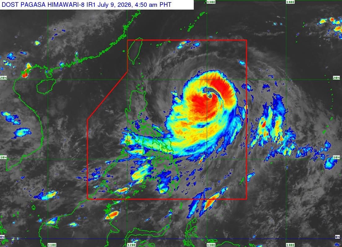
MANILA, Philippines — Tropical cyclone Inday (international name: Bavi) weakened into a typhoon early Thursday but continues to threaten Northern Luzon, with Signal No. 1 remaining in effect over several areas. In its 5 a.m. bulletin on Thursday, July 9, PAGASA said Inday was located 925 kilometers east of Northern Luzon, with maximum sustained winds of 175 kilometers per hour near the center and gustiness of up to 215 kph. It is moving west-northwestward at 20 kph. The following areas remain under Tropical Cyclone Wind Signal No. 1: Luzon Under Signal No. 1, strong winds ranging from 39 to 61 kph may be experienced within 36 hours, posing minimal to minor threats to life and property. PAGASA said the highest wind signal that may be raised during Inday's passage is Signal No. 2. Strong winds. PAGASA said the enhanced southwest monsoon and the typhoon's circulation will bring strong to gale-force gusts over most of the country from Thursday until Saturday, July 11, especially in coastal and upland areas exposed to winds. Heavy rainfall. PAGASA said Typhoon Inday and the enhanced southwest monsoon will continue to bring heavy rainfall over parts of the country in the coming days. Due to Typhoon Inday, Batanes may receive 50 to 100 millimeters of rainfall on Friday, July 10. Meanwhile, the southwest monsoon is forecast to bring: Thursday, July 9 Friday, July 10 Saturday, July 11 PAGASA warned that rainfall may be higher in mountainous and elevated areas and that flooding and rain-induced landslides may be worsened by significant antecedent rainfall. Sea conditions. A gale warning remains in effect over the northern and eastern seaboards of Luzon and the eastern seaboard of the Visayas. Very rough seas with waves reaching up to 6 meters are expected over the seaboards of Batanes, the northern and eastern seaboards of the Babuyan Islands, and the northeastern seaboard of mainland Cagayan, where all types of vessels are advised to remain in port or seek safe harbor. Rough to very rough seas are also expected over the seaboards of Isabela, Aurora, Camarines Norte, Camarines Sur, Catanduanes, Northern Samar and Eastern Samar. PAGASA advised operators of small seacraft, including motorbancas, not to venture out to sea in affected waters. Track, intensity. PAGASA said Inday is forecast to continue moving northwestward over the Philippine Sea and may pass closest to Extreme Northern Luzon between Friday evening, July 10, and Saturday morning, July 11. The typhoon is then expected to move toward the southern islands of Japan before making landfall or passing close to northern Taiwan. It is forecast to exit the Philippine Area of Responsibility (PAR) on Saturday, July 11, and make landfall over the eastern coast of mainland China on Sunday, July 12. PAGASA said Inday is forecast to gradually weaken but remain a typhoon while inside PAR before weakening into a severe tropical storm after moving inland over mainland China. It advised the public that heavy rainfall and damaging winds may still be experienced outside the forecast track and advised residents in affected areas to continue monitoring official weather bulletins.

多角的分析

経済的影響

台風「インディ」の進路は、ルソン島北部を中心に、農業や漁業といった一次産業に直接的な影響を与える可能性がある。特に、収穫期に近い農作物への被害は、地域経済の回復に長期的な影響を及ぼすことも考えられる。また、インフラへの被害が発生した場合、復旧には多額の費用と時間を要し、経済活動の停滞を招くリスクがある。フィリピン経済は、自然災害からの復旧力に依存する側面が強く、こうした気象現象への備えが常に求められる。

投資家心理

投資家にとって、台風「インディ」の接近は、短期的な市場のボラティリティを高める要因となり得る。特に、農業関連企業や、被害を受ける可能性のある地域に事業所を持つ企業は、サプライチェーンの寸断や生産活動の停止リスクに直面する。しかし、長期的な視点では、インフラ復旧や防災関連への投資機会も生まれる可能性がある。重要なのは、被害の規模と復旧のスピードを注視し、リスク管理を徹底することである。

社会的影響

台風「インディ」の接近は、ルソン島北部の住民、特に低所得者層や沿岸部・山岳地帯に住む人々にとって、直接的な生活への脅威となる。避難勧告やインフラの寸断は、日常生活を困難にし、食料や水の供給、医療へのアクセスを阻害する可能性がある。過去の台風被害では、コミュニティの連帯や政府・NGOによる支援が不可欠であった。今回も、被災者への迅速かつ効果的な支援が求められる。

市民の声

今回の台風「インディ」の進路は、ルソン島北部の住民にとって、直接的な脅威となります。特に、沿岸部や山岳地帯に住む人々は、高波や洪水、土砂災害の危険に晒されています。避難勧告が出された地域では、住民は安全な場所への移動を余儀なくされ、生活物資の確保やインフラの復旧が課題となります。過去の台風被害の経験から、住民は早期の避難と物資の備蓄の重要性を認識していますが、経済的な理由から避難が困難な人々も少なくありません。

背景・歴史的文脈

フィリピンは太平洋「火山の輪」に位置し、台風銀座とも呼ばれる地域にあり、年間平均20個以上の台風が通過する。特に、9月から11月にかけては大型の台風が襲来しやすい時期である。過去には、2013年の台風「ヨランダ」(ハイエン)のように、壊滅的な被害をもたらした例もあり、国民生活や経済に大きな影響を与えてきた。そのため、フィリピン政府は気象庁(PAGASA)を中心に、早期警戒システムの強化や防災インフラの整備に努めているが、自然災害への脆弱性は依然として大きな課題となっている。今回の「インディ」も、こうしたフィリピンが抱える自然災害リスクの一例である。

原文ソース

Philstar Nation

原文を読む