Super Typhoon Ba Vi Could Affect East Sea
Super Typhoon Ba Vi, originating in the northwestern Pacific, is unlikely to directly impact Vietnamese waters but its extensive circulation may bring strong winds and high waves to the East Sea. Vietnam's National Center for Hydro-Meteorological Forecasting is closely monitoring its development.
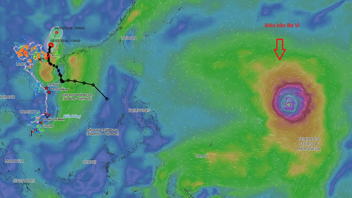
Super Typhoon Ba Vi, a powerful storm forming in the northwestern Pacific, is unlikely to directly enter Vietnamese waters but its extensive circulation could bring strong winds and high waves to the East Sea, according to the National Center for Hydro-Meteorological Forecasting. As of 4 PM on July 5, the typhoon's eye was approximately 2,500 km east of central Philippines, with sustained winds of Category 17, gusting higher. This marks the third super typhoon in the northwestern Pacific this year. Over the next 24 hours, the typhoon is expected to move west-northwest at about 20 km/h. From July 6-9, Ba Vi is forecast to maintain its super typhoon intensity and continue its predominantly west-northwest trajectory. Around July 10, it may shift course northwestward, heading towards Taiwan (China). Japan's Meteorological Agency reports Ba Vi's winds at 200 km/h, expected to persist. The US Navy's Joint Typhoon Warning Center estimates winds near 280 km/h, projecting this intensity through tomorrow. International meteorological agencies concur that the super typhoon will not enter the East Sea. The Vietnamese center assesses the probability of Ba Vi entering the East Sea as less than 10%. However, due to its immense strength, the typhoon's outer bands could affect the northeastern East Sea from July 9-11. Furthermore, the typhoon's "wind-sucking effect" is predicted to intensify the southwest monsoon over the East Sea starting July 9. During July 9-11, winds in the northern, central, and southern East Sea, including areas around the Hoang Sa (Paracel) and Truong Sa (Spratly) Islands, may reach level 6-7, with waves 3-5 meters high, indicating very rough seas. The center is closely monitoring Ba Vi's developments and will issue updated forecasts as they become available. Previously, Typhoon Maysak caused significant damage in areas like Mong Cai city and Co To island in northern Vietnam, including damaged homes, vehicles, and vessels, power outages, and agricultural losses, with estimated material damages around VND 20 billion. The 2026 rainy and typhoon season is predicted to have fewer storms and tropical depressions affecting Vietnam compared to the average and 2025. However, experts warn of unpredictable storm behavior due to climate change, with rapid shifts in track and intensity possible, especially late in the season.
多角的分析
台風バビの直接的なベトナム本土への上陸は予測されていないが、東シナ海における強風と高波は、ベトナムの海上輸送、漁業、そして沿岸部のインフラに間接的な経済的影響を与える可能性がある。特に、7月9日から11日にかけて予測される強風と高波は、船舶の運航遅延や漁獲量の減少、沿岸施設の被害を引き起こし、短期的な経済活動の停滞を招く恐れがある。過去の台風被害額(約200億ドン)を考慮すると、直接的な被害がなくとも、経済活動への影響は無視できない。
現時点では、台風バビがベトナム経済に直接的な壊滅的影響を与える可能性は低いと見られており、投資環境への短期的な大きな変動要因とはならないだろう。しかし、東シナ海での海上輸送の混乱や、沿岸部でのインフラへの潜在的な影響は、サプライチェーンの遅延リスクとして、一部の製造業や貿易関連企業にとっては注意が必要な要素となる。長期的な視点では、気候変動による異常気象の頻発化が、ベトナムのインフラ投資やリスク管理戦略に影響を与える可能性があり、投資判断において考慮すべき点が増えると考えられる。
台風バビの直接的な影響は限定的と予測されているものの、東シナ海での強風と高波は、沿岸地域に住む漁民や船乗りたちの生計に影響を与える可能性がある。また、海上輸送の混乱は、地域間の物資供給に遅れを生じさせ、日常生活品の値上がりを招くことも考えられる。過去の台風被害の経験から、住民は常に警戒を怠らないだろう。気候変動による異常気象の頻発化は、ベトナム社会全体にとって、防災意識の向上やインフラ強化の必要性を改めて浮き彫りにしている。
台風バビが直接ベトナムに上陸しないというニュースは、多くの市民にとって安心材料となるだろう。しかし、東シナ海での高波や強風の予報は、特に沿岸部や島嶼部に住む人々、あるいは漁業に関わる人々にとっては、依然として懸念材料となる。過去の台風被害の記憶が残る中、地域住民は最新の気象情報を注視し、安全確保に努めるだろう。また、気候変動による異常気象の増加という背景は、将来的な災害への備えという点で、社会全体の意識を高めるきっかけとなる可能性がある。
背景・歴史的文脈
ベトナムは、南シナ海(東シナ海)に面しており、毎年多くの台風や熱帯低気圧の影響を受けている。これらの気象現象は、ベトナムの経済、特に農業、漁業、そして海上輸送に大きな影響を与える。過去の事例では、台風による甚大な被害は、インフラの復旧や経済活動の再開に多大なコストを要してきた。気候変動の影響により、近年、台風の強度が増し、予測が困難になる傾向が見られる。ベトナム政府は、防災・減災対策の強化、早期警報システムの整備、そして気候変動への適応策を進めているが、その対応は常に喫緊の課題となっている。
原文ソース
VnExpress