General articles are free for 24 hours after publish.
LPA Affects Palawan, Visayas Amid Severe Tropical Storm Dujuan Watch
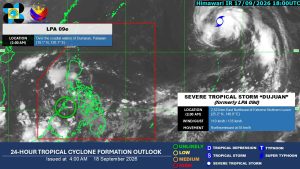
A low pressure area (LPA) is impacting Palawan, triggering thunderstorms in the Visayas and other regions, according to the Philippine Atmospheric, Geophysical and Astronomical Services Administration (PAGASA). Meanwhile, Severe Tropical Storm Dujuan is being monitored at a distance.
A low pressure area (LPA) is currently affecting Palawan and causing thunderstorms in seven areas, posing a risk of flash floods and landslides amid the continued presence of severe tropical storm Dujuan, the state weather bureau said on Friday. “The LPA was located over Dumaran, Palawan and is currently traversing Palawan,” Leanne Loreto, weather specialist of the Philippine Atmospheric, Geophysical and Astronomical Services Administration (PAGASA), said in a 5:00 a.m. press briefing in Filipino. The LPA is likely to cause thunderstorms in Visayas, MIMAROPA and Bicol Region in the next 24 hours, PAGASA said in a separate 4:00 a.m. weather advisory. It is likewise expected to affect Zamboanga Peninsula, Northern Mindanao, Batangas and Quezon. PAGASA warned of possible flash floods and landslides during moderate to occasionally heavy rains. The LPA is expected to dissipate, and the number of affected areas may decrease in the next 24 hours, Ms. Loreto said. Meanwhile, severe tropical storm Dujuan is still being monitored by PAGASA and was located 2,460 kilometers east-northeast of Extreme Northern Luzon, based on PAGASA’s press briefing. It intensified to 110 kilometers per hour (kph) of maximum sustained winds and 135 kph of gustiness. “We are no longer expecting it to enter our area of responsibility, and it is not expected to affect the country,” Ms. Loreto said. — Edg Adrian A. Eva
Original source
BusinessWorld Nation