General articles are free for 24 hours after publish.
Tropical Depression Triggers Heavy Rains, Flood Risks in Central Vietnam
Central Vietnam is bracing for a tropical depression, with heavy rains already causing floods and landslides over the weekend. The approaching system is expected to exacerbate these conditions, posing a high risk of flash floods and inundation in vulnerable areas.
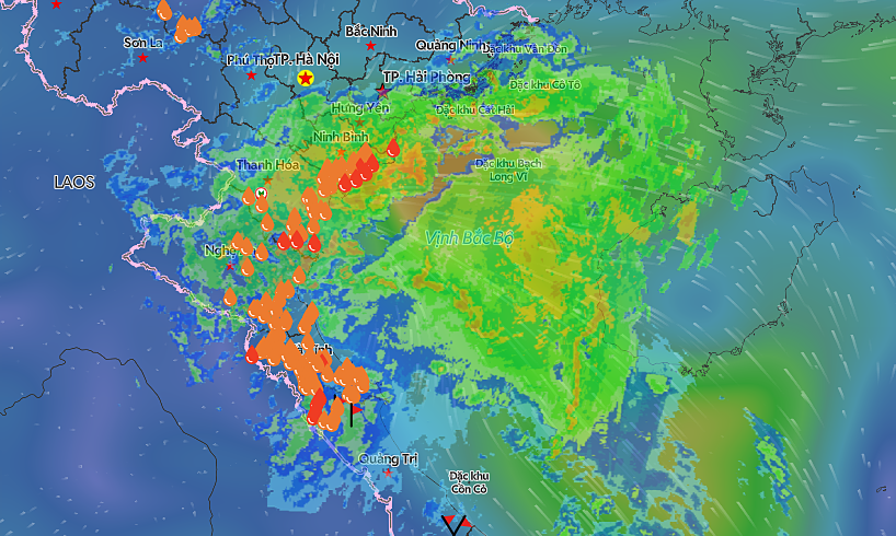
Authorities in Vietnam's central region are preparing for the impact of a tropical depression, following heavy rains that caused floods and landslides across several areas over the weekend. As of early September 14, the depression was located over inland coastal areas of Ha Tinh Province and northern Quang Tri, with sustained winds of 39-74 km per hour, according to the National Center for Hydrometeorological Forecasting (NCHMF). The NCHMF predicts the depression will continue moving west-northwest at about 10 km per hour, passing through Quang Tri and Ha Tinh into central Laos before gradually weakening into a low-pressure system. While not particularly intense, the tropical depression is expected to bring rain over a very large area, affecting numerous provinces and cities in the north and central regions. Central localities like Thanh Hoa, Nghe An, Ha Tinh, Quang Tri, Hue, and Da Nang are anticipated to be impacted. In the north, affected areas include the midlands and deltas, along with southern parts of Son La, Phu Tho, Tuyen Quang, and Lao Cai provinces. The disaster risk level has been assessed at level three out of five. Sea areas from southern Nghe An to Hue City are expected to experience strong winds and rough seas with waves up to 4 meters, posing risks to fishing vessels, cargo ships, and tourist boats. Aquaculture cages, mooring areas, and coastal structures are also vulnerable. On September 15, moderate to heavy rain and thunderstorms are forecast for the northern midlands and deltas, southern parts of Son La, Phu Tho, Tuyen Quang, and Lao Cai provinces, as well as Thanh Hoa, Nghe An, Ha Tinh, and Quang Tri. Rainfall is expected to range from 30-60mm, potentially exceeding 100mm in some locations, and is likely to persist until the morning of September 16. The NCHMF warns of a very high risk of flash floods and landslides in mountainous regions and widespread inundation in low-lying areas of Thanh Hoa, Nghe An, Ha Tinh, Quang Tri, and Hue due to the prolonged heavy rainfall. Isolated heavy rain on the evening of September 12 had already caused rapid water level rises in many parts of Da Nang, leading to localized flooding and necessitating the urgent evacuation of residents from deeply flooded areas. In several mountainous districts of Quang Tri Province, bridges, weirs, and roads were inundated, causing isolation. The Se Pon River's rise flooded Lao Bao Commune, prompting the relocation of nearly 60 households. Embankment landslides blocked National Highway 15D and provincial roads, while sections of the Ho Chi Minh Road were also affected by landslides. Local authorities in Ba Long Commune reported that many bridges and weirs were deeply submerged, with some reaching depths of up to 3 meters. Warning signs were erected, and guards were stationed to prevent entry into hazardous areas. In Ba Long Commune, 107 households comprising 331 people, primarily the elderly, women, and children in landslide- and flood-prone areas, were relocated to safety. Lieutenant Colonel Tran Duy Hung, deputy head of the La Lay Border Guard Post, stated, "At present, it is still raining very heavily. River and stream levels are rising sharply, causing fast-flowing water over flooded bridges in the area." He added that response plans were in place, with personnel deployed to block off flooded bridges and ensure safety. Information source: VnExpress International
Original source
VnExpress International