Environment
LPA Expected to Enter PAR, Potential Tropical Depression Kiyapo to Bring Rains
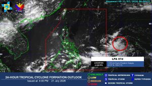
A low-pressure area (LPA) is forecast to enter the Philippine Area of Responsibility (PAR) early this week and has a high chance of developing into a tropical depression. If it forms, it will be named Kiyapo, the 11th tropical cyclone of the year, and is expected to bring rains across large parts of the country.
This article requires PRO
This article is outside the free access window or is a special report. PRO unlocks it and the full archive.
Related articles
- LPA Enters PAR, May Intensify into Cyclone 'Kiyapo'
A low-pressure area (LPA) has entered the Philippine area of responsibility (PAR) and may develop into a tropical cyclone named 'Kiyapo' within 24 hours, according to PAGASA. It is expected to bring rain to northern areas by the weekend.