Tropical Depression Henry Forecast to Exit PAR Wednesday Evening or Early Thursday
Tropical Depression Henry is forecast to exit the Philippine Area of Responsibility (PAR) on Wednesday evening or early Thursday, according to the state weather bureau (Pagasa). It is currently moving northwest with maximum sustained winds of 45 kph and may develop into a tropical storm over the West Philippine Sea.
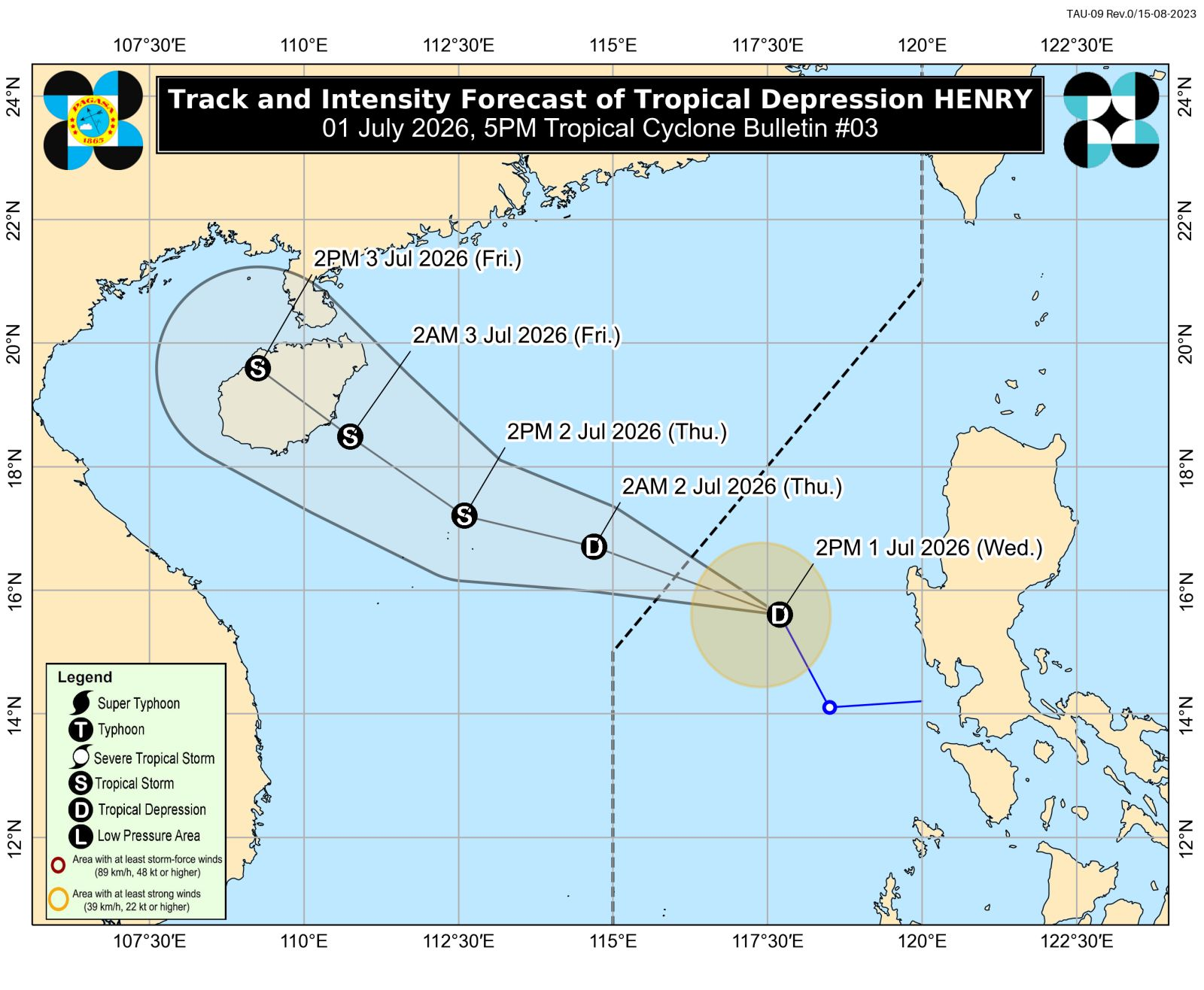
MANILA, Philippines — Tropical depression Henry is forecast to exit the Philippine area of responsibility (PAR) on Wednesday evening or early Thursday, according to the state weather bureau on Wednesday. In its 5 p.m. weather bulletin, the Philippine Atmospheric, Geophysical and Astronomical Services Administration (Pagasa) said that Henry was located 315 kilometers west of Dagupan City in Pangasinan as of 4 p.m. READ: Pagasa lifts wind signals; Henry moves away from PH landmass Henry maintained its strength as it was carrying a maximum wind speed of 45 kilometers per hour (kph) and gustiness of up to 55 kph. It was moving north-northwestward at 30 kph. “Henry is forecast to move generally west northwestward away from the Philippine landmass. It is expected to exit the Philippine area of responsibility (PAR) this evening or tomorrow morning (02 July),” Pagasa said. The tropical depression is predicted to gradually intensify while moving over the West Philippine Sea and may develop into a tropical storm by Thursday afternoon. READ: Pagasa: Over 60% chance of El Niño intensifying from August onwards Henry’s periphery and the southwest monsoon or habagat will bring strong to gale-force gusts over the following areas: The following coastal waters will experience relatively moderate sea conditions:
多角的分析
熱帯低気圧「ヘンリー」の進路は、フィリピン経済に直接的な大きな影響を与える可能性は低いものの、その周辺地域で予想される強風は、特に農業や漁業に一時的な打撃を与える可能性があります。また、西フィリピン海での発達が熱帯低気圧から熱帯低気圧へ移行した場合、海上輸送や漁業活動への影響が懸念されます。これは、フィリピン経済の回復力と、気象変動への適応能力を試す一例と言えます。
今回の熱帯低気圧「ヘンリー」の動向は、短期的な投資環境においては、直接的な大きなリスク要因とは見なされないでしょう。しかし、フィリピンが台風や熱帯低気圧の影響を受けやすい国であることを再認識させる機会となります。インフラ関連企業や保険会社にとっては、自然災害への対応能力が引き続き評価のポイントとなるでしょう。長期的な視点では、気候変動への適応策を講じる企業の持続可能性が重要視されると考えられます。
熱帯低気圧「ヘンリー」の接近は、直接的な被害が限定的であっても、フィリピン沿岸地域や低地の住民にとって、常に警戒を促すものです。過去の台風被害の記憶から、住民は早めの避難や備蓄の確認といった行動をとる可能性があります。また、南西モンスーン(ハバガット)の影響が続く場合、都市部では雨による交通渋滞や浸水のリスクも高まります。これは、公共インフラの脆弱性と、地域社会の危機管理体制の重要性を浮き彫りにします。
熱帯低気圧「ヘンリー」の通過は、多くのフィリピン市民にとって、日常生活への一時的な影響に留まるでしょう。しかし、沿岸部や脆弱な地域に住む人々にとっては、過去の経験から、常に警戒が必要です。特に、雨季の到来と重なるため、交通機関の遅延や、農作物への被害による物価への影響も無視できません。市民は、気象庁からの最新情報に注意を払い、安全確保に努めることが求められます。
背景・歴史的文脈
フィリピンは、太平洋の「火山の輪」に位置し、台風銀座とも呼ばれる地域にあり、年間平均20個以上の台風や熱帯低気圧の影響を受けます。これらの気象現象は、フィリピンの地理的条件、海洋からの湿った空気の流入、そして高緯度からの寒気団との相互作用によって発生します。特に、熱帯低気圧が西フィリピン海(南シナ海の一部)で発達・進路を変えることは、フィリピンの気象パターンにおいて頻繁に見られる現象であり、過去には甚大な被害をもたらした台風も少なくありません。そのため、フィリピン気象庁(Pagasa)は、国民の安全確保のために、常に最新の気象情報を発表し、警戒を呼びかけています。
原文ソース
Inquirer NewsInfo