General articles are free for 24 hours after publish.
Hanoi Unveils Red River Urban Development Plan, Divided into Three Sections
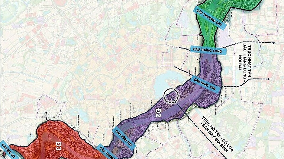
Hanoi has announced an urban development plan for a vast area along the Red River (approximately 11,418 hectares), divided into three sections based on bridges spanning the river. Each section will have distinct roles, aiming to create a sustainable riverside urban environment.
Hanoi has unveiled a comprehensive urban development plan for a significant stretch along the Red River, encompassing an area of approximately 11,418 hectares and extending for 40 kilometers. This ambitious project delineates the riverside zone into three distinct sections, identified by the bridges that span the river. The overarching objective is to comprehensively reorganize the urban landscape along the Red River, fostering a balanced development that prioritizes a green and sustainable living environment. Each of the three sections is designed to fulfill specific roles crucial for enhancing the transportation network, integrating diverse urban functions, creating a robust economic development framework, and shaping public spaces and scenic vistas that are intrinsically Vietnamese. Section 1: From Hong Ha Bridge to Thang Long Bridge This segment covers an area of approximately 3,436 hectares and is projected to house 160,000 residents. Its primary focus is on ecological preservation, featuring natural conservation spaces, specialized theme parks, sports complexes, and landscaped green areas. Alongside the renovation of existing village settlements, the plan includes the development of multi-functional urban zones dedicated to commerce, services, and logistics, as well as residential housing. Building heights in this section are set to a maximum of 30-45 stories. Construction density regulations vary, with service and public land allocated up to 60% and residential land between 35-40%. Section 2: From Thang Long Bridge to Thanh Tri Bridge Spanning roughly 4,548 hectares and accommodating an estimated population of 541,000, this is the largest of the three sections. It is envisioned as the core of the Red River urban area, concentrating public, cultural, commercial, and service functions, alongside significant landscape spaces. This section is specifically designated as the "urban living room," a strategic area for landmark constructions that will link the West Lake – Co Loa region, complemented by a network of public and cultural spaces. The urban development zones and parks are planned in an interspersed manner. Similar to Section 1, the maximum building height is set at 30-45 stories. Section 3: From Thanh Tri Bridge to Me So Bridge This section encompasses approximately 3,435 hectares and is expected to house around 499,000 people. It is planned to integrate commercial, service, and transportation functions with eco-agricultural parks and resort developments that offer creative experiences. A key aspect of this section is the preservation and restoration of historical and cultural assets to boost tourism. The Bat Trang village area is designated for heritage conservation and resettling residents. Commercial, service, and logistics functions will be closely tied to the Thanh Tri and Bat Trang ports, with Bat Trang's traditional craft village integrated into the urban development and tourism strategy. Collectively, these sections are designed for cohesive development. The plan includes reorganizing residential areas outside the dikes, establishing new urban developments and service facilities along major transportation arteries, and strategically placing high-rise buildings along the riverfront. The height of these structures will gradually decrease towards the dikes, creating a buffer zone between the high-density urban areas and the traditional villages. This planning approach aims to optimize the utilization of landscape resources for ecological tourism, enhance educational and healthcare facilities, and expand green spaces. The implementation of this ambitious plan will proceed in phases. The initial phase, scheduled from 2026 to 2030, will focus on constructing the riverside landscape avenues, riverbank protection and stabilization works, developing parks such as Phu Thuong Park and parks along the Hong Ha ward riverbank, establishing the "urban living room" area, and undertaking resettlement projects in Long Bien and Linh Nam. The subsequent phase, from 2030 to 2038, will see the completion of the remaining component projects, bringing the entire vision to fruition.
Original source
VnExpress