LPA May Intensify into Tropical Cyclone 'Henry,' PAGASA Warns of Storm Signals
The Philippine Atmospheric, Geophysical and Astronomical Services Administration (PAGASA) announced a high probability of a monitored low-pressure area developing into a tropical cyclone. If it intensifies, it will be named 'Henry,' the country's eighth tropical cyclone this year, potentially leading to Storm Signal No. 1 in several areas.
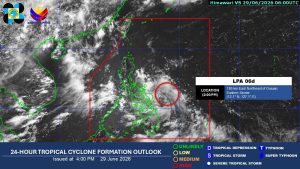
The Philippine Atmospheric, Geophysical and Astronomical Services Administration (PAGASA) announced on Monday that a monitored low-pressure area (LPA) has a "high" chance of developing into a tropical cyclone, which may prompt the hoisting of Storm Signal No. 1 in several areas. "The LPA has a high chance of developing into a tropical cyclone within the next 24 hours," PAGASA weather specialist Charmagne Varilla said during a 5 p.m. press briefing. The weather disturbance will be given the local name “Henry,” the country’s eighth tropical cyclone this year. Potential tropical depression Henry was last located 165 kilometers east-northeast of Borongan City, Eastern Samar. Ms. Varilla said that following its development, Storm Signal No. 1 will likely be hoisted in several areas. These include the Bicol Region, Quezon Province, Batangas, Occidental Mindoro, Oriental Mindoro, Marinduque, and Romblon. A yellow rainfall warning was also issued for Sorsogon, Albay, Masbate, Northern Samar, Eastern Samar, Samar, Biliran, Leyte, Marinduque, Romblon, and Oriental Mindoro. PAGASA said this means that heavy rainfall ranging from 50 to 100 millimeters is expected in these areas within the next 24 hours as of 5 p.m. The bureau also warned of possible flooding and landslides in areas prone to these hazards under the rainfall warning. As for potential Henry’s forecast track, PAGASA said in an earlier press briefing that it may traverse Southern Luzon and the Visayas on Tuesday before emerging over the West Philippine Sea on Wednesday. — Edg Adrian A. Eva
多角的分析
熱帯低気圧の接近は、フィリピン経済に直接的な影響を与える。特に、農業分野では作物の被害や収穫遅延が生じ、漁業も操業停止を余儀なくされるため、食料供給や物価に影響が出かねない。また、インフラへの被害は復旧に時間を要し、経済活動の停滞を招く可能性がある。BPO(ビジネス・プロセス・アウトソーシング)産業など、サービス業も停電や交通網の寸断により業務に支障をきたすリスクがある。
投資家にとって、熱帯低気圧の接近は短期的なリスク要因となる。インフラへの被害やサプライチェーンの寸断は、企業の操業に影響を与え、収益を圧迫する可能性がある。しかし、フィリピンは熱帯低気圧の通り道であり、投資家はこれらのリスクを織り込み済みであることが多い。むしろ、復旧需要や、気候変動対策に関連するインフラ投資の機会に注目する動きもあり得る。
熱帯低気圧「ヘンリー」の接近は、特に低地や山間部に居住する住民にとって、洪水や土砂崩れの危険性を高める。PAGASAによる警報は、住民に避難を促すための重要な情報源となるが、避難所の収容能力や、避難生活における衛生・食料問題なども課題となる。また、交通網の寸断は、日々の生活必需品の供給にも影響を及ぼし、特に地方ではその影響が深刻化する可能性がある。
今回の熱帯低気圧「ヘンリー」の発生予測は、フィリピン国民、特に被害を受けやすい地域に住む人々にとって、直接的な不安材料となります。過去の台風被害の経験から、住民は早期の避難や備蓄の準備を進めるでしょう。しかし、避難所の状況や、避難後の生活再建への不安は常に存在します。また、交通網の寸断は、日々の通勤・通学や物資の流通に影響を与え、生活コストの上昇につながる可能性も懸念されます。
背景・歴史的文脈
フィリピンは、太平洋の「火の輪」と呼ばれる地震多発地帯に位置し、さらに太平洋の西端に位置するため、世界でも有数の熱帯低気圧の通り道となっている。年間平均で20個以上の熱帯低気圧がフィリピン近海を通過または上陸し、そのうち数個は甚大な被害をもたらす強力な台風となる。特に、2013年の台風ハイエン(ヨランダ)のような超大型台風は、壊滅的な被害をもたらし、フィリピンの災害対策の脆弱性を浮き彫りにした。このため、フィリピン政府はPAGASAを通じて常時気象監視を行い、早期警報システムの強化や防災インフラの整備に努めているが、地理的要因による自然災害のリスクは依然として高い。
原文ソース
BusinessWorld Nation