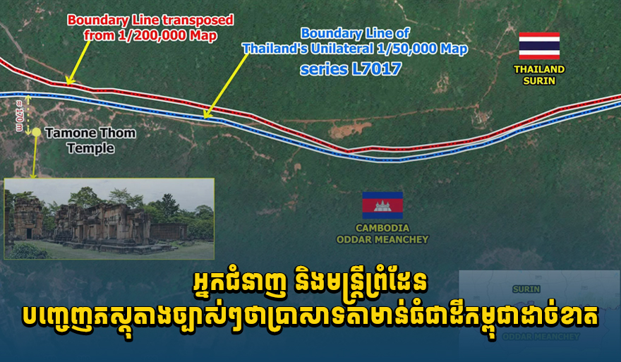
Cambodia Accuses Thailand of Illegally Occupying Ta Moan Thom Temple, Citing Historical Maps
Cambodia asserts that Thailand is illegally occupying the Ta Moan Thom temple complex. Citing historical maps from the Franco-Siamese Indochina Commission (1908, 1919) and a unilateral Thai map, Cambodia claims the site unequivocally belongs to its territory. The country also notes a lack of cooperation from Thailand.
Cambodia has accused Thailand of illegally occupying the Ta Moan Thom temple complex, presenting clear evidence that the site belongs to Cambodian territory. Experts and border officials in Cambodia cite historical maps from the Franco-Siamese Indochina Commission (1908, 1919) at a scale of 1:200,000, records of boundary markers from 1908 and 1919, and a unilateral Thai-drawn map at a scale of 1:50,000, designated L7017. Dr. Ki Sereyvath, an economic expert from the Royal Academy of Cambodia, stated on social media that the Thai military has illegally occupied Ta Moan Thom and other Cambodian territories by force, with the intention of unilaterally altering the border. He urged Thailand to cease deceiving its own citizens and the international community, particularly the UN Security Council. The Secretariat of State for Border Affairs reiterated that, based on the 1:200,000 scale map and records of boundary markers from the Franco-Siamese Indochina Commission (1908, 1919), as well as the unilateral Thai map L7017, Ta Moan Thom is situated within Cambodian territory. The Secretariat emphasized that the individuals, institutions, organizations, or units most knowledgeable about the precise border line and the location of boundary markers, and who have the authority to verify and confirm the true international border line between Cambodia and Thailand and the exact locations of boundary markers during the French colonial era on the actual land, are the members of the Joint Boundary Commission (JBC) and its technical survey teams. Sources claim that Thailand is attempting to mislead public opinion and its own citizens through illegal actions at temples within Cambodian sovereign territory that it has occupied unlawfully. However, it cannot deceive international law. From a legal standpoint, these temples are unequivocally Cambodian and lie within Cambodian sovereign territory. In conjunction with this, the Cambodian side of the JBC has sent multiple diplomatic notes to the Thai side of the JBC requesting the dispatch of joint survey teams to continue their work on the ground. However, a positive response has not been received, with Thailand reportedly making excuses, which contradicts Article 3 of the Joint Statement dated December 27, 2025, stipulating that 'Cambodia and Thailand shall dispatch joint survey teams to the actual land to continue their work as soon as possible.' Source: Koh Santepheap Khmer
多角的分析
タ・モアン・トム遺跡を巡るカンボジアとタイの領有権問題は、直接的な経済的影響は現時点では限定的である。しかし、国境紛争は両国の観光業に影を落とす可能性がある。特に、遺跡周辺の観光資源へのアクセスが制限されたり、両国間の緊張が高まることで、地域全体の観光客の足が遠のくリスクが考えられる。また、長期化すれば、国境地域における経済活動や投資にも不確実性をもたらしうる。
このニュースは、カンボジアへの直接投資を検討している投資家にとって、地政学的なリスク要因として注視すべきである。国境紛争は、予期せぬ外交的緊張や、最悪の場合、小規模な衝突に発展する可能性を孕んでおり、これが地域全体の安定性を損なう懸念がある。特に、タイとの国境付近での事業展開を計画している場合、慎重なリスク評価が求められる。過去の類似事例では、国境紛争が投資家のセンチメントを悪化させ、資本流出を招いたケースもある。
タ・モアン・トム遺跡を巡る領有権問題は、カンボジア国民のナショナリズムを刺激する可能性がある。歴史的遺産に対する愛着は強く、自国の領土が外国によって占拠されているという認識は、国民の間に強い反発を生むことが予想される。また、タイ側の「一方的な地図作成」や「国民への欺瞞」といった非難は、両国民間の感情的な対立を深める要因となりうる。SNSなどを通じて情報が拡散されることで、国民感情の波がさらに高まることも考えられる。
タ・モアン・トム遺跡を巡る領有権問題は、カンボジア市民の愛国心を刺激する一方で、国境地域に住む住民の生活に直接的な影響を与える可能性がある。もし紛争がエスカレートすれば、避難や生活基盤の喪失といった事態も想定される。また、タイとの国境交易に依存している地域経済にとっては、両国関係の悪化が物流の停滞や経済活動の縮小につながる懸念がある。市民は、政府の対応とともに、自身の生活への影響を注視している。
背景・歴史的文脈
カンボジアとタイの国境線は、特にフランス植民地時代に画定された地域において、歴史的に不明瞭な部分や、両国間で解釈の相違が生じる箇所が存在する。1908年と1919年の仏印・シャム委員会による地図と記録は、当時の国境画定の根拠とされるが、タイ側は独自の解釈や、後年の一方的な地図作成によって、一部の領土や遺跡の帰属を主張してきた経緯がある。特に、アンコール遺跡群周辺や、タイとの国境地帯には、歴史的・文化的に重要な遺跡が点在しており、これらの帰属を巡っては、両国間で感情的な対立や外交的な駆け引きが繰り返されてきた。今回の「タ・モアン・トム」遺跡を巡る問題も、こうした歴史的背景と、両国のナショナリズム、そして地域における地政学的な影響力のバランスが複雑に絡み合った結果として理解される。
原文ソース
Koh Santepheap Khmer