Typhoon Kiyapo moves away from Philippines, but monsoon rains persist
Environment
2026年7月25日
5
Rappler Philippines

General articles are free for 24 hours after publish.

Typhoon Kiyapo moves away from Philippines, but monsoon rains persist

Share
AI Summary

Rainfall and wind warnings due to Typhoon Kiyapo (Noul) have been lifted, but scattered rain and thunderstorms are expected to continue across the Philippines due to the southwest monsoon. Risks of floods and landslides remain, particularly in Northern Luzon and MIMAROPA.

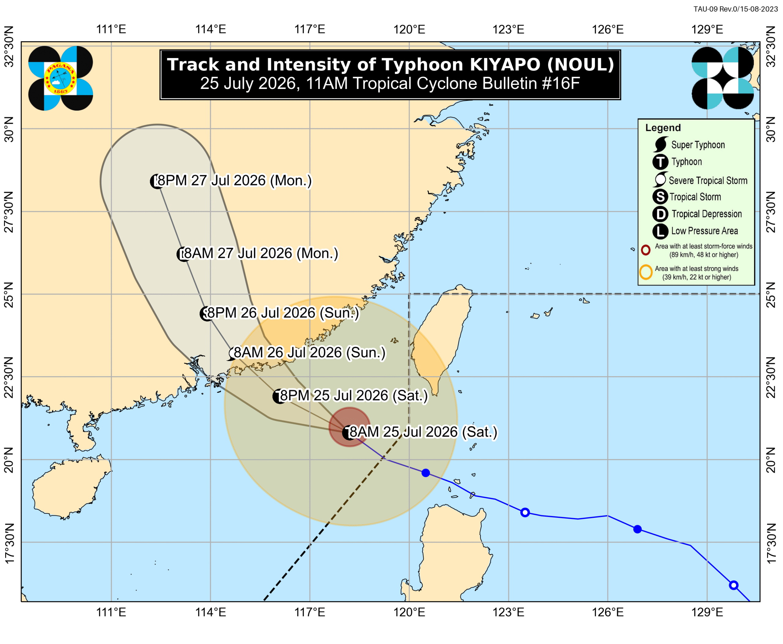
MANILA, Philippines – Rainfall and wind warnings due to Typhoon Kiyapo (Noul) were lifted at 11 am on Saturday, July 25, as the tropical cyclone continued to move outside the Philippine Area of Responsibility (PAR), heading for China. The Philippine Atmospheric, Geophysical, and Astronomical Services Administration (PAGASA) said Kiyapo was last spotted 465 kilometers west of Basco, Batanes, at 10 am. The typhoon is moving northwest at 25 kilometers per hour, still with maximum sustained winds of 120 km/h and gustiness of up to 150 km/h. It had left PAR at 2 am on Saturday. PAGASA said in its 11 am bulletin that Kiyapo may strengthen in the next 12 hours, ahead of its expected landfall in China. But it may weaken quickly once it moves further inland there. In the Philippines, Kiyapo made landfall as a tropical storm in Camiguin Island, Calayan, Cagayan, at 2:10 pm on Friday, July 24. It brought moderate to intense rain to Northern Luzon, and Signal No. 3 was the highest tropical cyclone wind signal raised. While Kiyapo is no longer posing a threat to any part of the Philippines, the southwest monsoon or habagat continues to trigger scattered rain and thunderstorms across the country. The following provinces are currently the most affected: Saturday noon, July 25, to Sunday noon, July 26 Moderate to heavy rain (50-100 millimeters): Pangasinan, Zambales, Bataan, Occidental Mindoro Sunday noon, July 26, to Monday noon, July 27 Moderate to heavy rain (50-100 mm): Pangasinan, Zambales Floods and landslides can still occur. Must Read Heavy monsoon rain triggers severe Davao flooding, evacuations The southwest monsoon and the typhoon’s periphery or outer bands are also bringing strong to gale-force gusts to these areas: Saturday, July 25 most of Luzon, Western Visayas, Negros Island Region, Northern Samar, Zamboanga del Norte, Davao Oriental Sunday, July 26 Batanes, Cagayan, Ilocos Region, Zambales, Bataan, Quezon, Mimaropa Monday, July 27 La Union, Pangasinan, Zambales, Lubang Islands, Kalayaan Islands Meanwhile, conditions at sea are starting to gradually improve, although travel remains dangerous for small vessels in certain seaboards. Up to rough seas (small vessels should not venture out to sea) Seaboard of Batanes – waves up to 3.5 meters high Seaboard of Babuyan Islands; northern seaboard of Ilocos Norte; northeastern seaboard of mainland Cagayan – waves up to 3 meters high Up to moderate to rough seas (small vessels should take precautionary measures or avoid sailing, if possible) Northern seaboards of Isabela and Ilocos Sur; western seaboard of Kalayaan Islands; remaining seaboards of mainland Cagayan and Ilocos Norte – waves up to 2.5 meters high Seaboard of Zambales; northern seaboard of La Union; western seaboards of Pangasinan, Bataan, Calamian Islands, and Occidental Mindoro including Lubang Islands; eastern seaboard of Davao Oriental; remaining seaboards of Isabela, Ilocos Sur, and Kalayaan Islands – waves up to 2 meters high Kiyapo was the Philippines’ 11th tropical cyclone for 2026, and the fourth for July alone. – Rappler.com

0

Original source

Rappler Philippines

原文を読む