General articles are free for 24 hours after publish.
Vietnam Offshore Low-Pressure System May Intensify into Typhoon, Taking Unusual Path
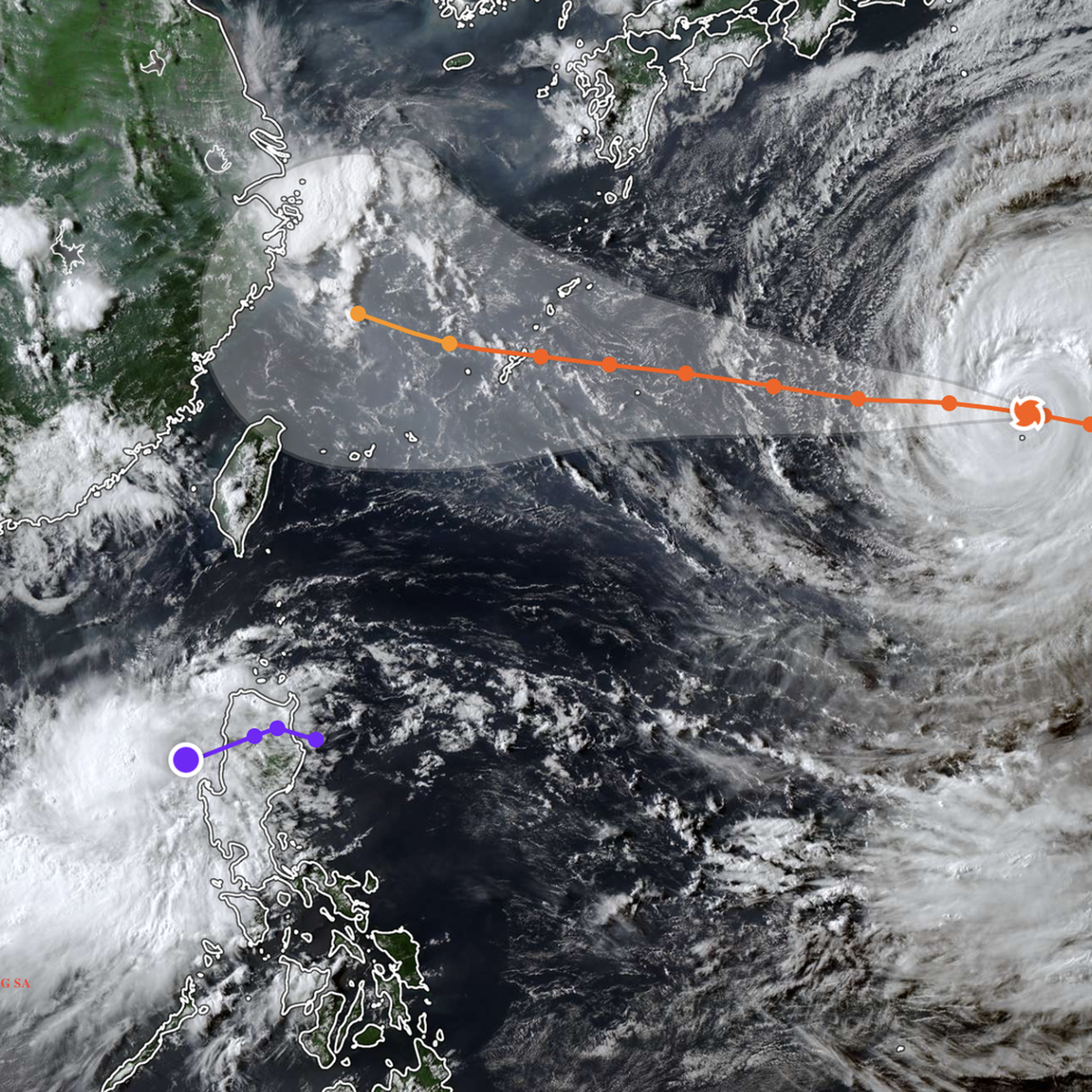
A tropical low-pressure system off the coast of Vietnam may strengthen into a typhoon (the season's third), taking an unusual path towards the Philippines, according to the latest meteorological forecasts. This deviation is attributed to interactions with Typhoon Dolphin in the Western Pacific.
A tropical low-pressure system developing in the waters off Vietnam is showing potential to intensify into a typhoon, the third of the season, and is charting an unusual course away from the mainland, meteorological authorities have reported. The system is projected to move eastward towards the Philippines. As of 5 PM on August 4, the National Hydro-Meteorological Forecasting Center indicated the center of the tropical low-pressure system was located in the southeastern waters of the northern East Sea, with maximum sustained winds at level 6-7 (39-61 km/h) and gusts up to level 9. In the next 24 hours, the system is expected to move southeastward, exiting the East Sea and potentially strengthening into a typhoon. If the low-pressure system strengthens into a typhoon west of the 120th meridian, it would be the third typhoon of the 2026 season. However, the latest forecasts suggest it will head towards the northwestern coastal areas of Luzon Island, Philippines, where it may strengthen into a typhoon with winds at level 8 (62-74 km/h) and gusts at level 10. Subsequently, it is predicted to weaken into a tropical depression after crossing Luzon and continue moving eastward, further weakening over the northeastern waters of Luzon. The notable aspect of this tropical cyclone is its eastward trajectory, diverging from the typical westward movement of storms affecting Vietnam. This eastward path means the Vietnamese mainland and coastal areas are unlikely to be directly impacted. This unusual track is attributed to interaction with Typhoon Dolphin, currently located in the northwestern Pacific Ocean. The two systems are approximately 2,500 km apart. Typhoon Dolphin is currently heading towards Okinawa, Japan, and is then expected to move towards mainland China. As Typhoon Dolphin approaches Taiwan, southerly winds in the southern East Sea are anticipated to strengthen from tomorrow. Currently, strong winds of level 6-7 (gusting to level 9, later to level 8 with gusts to level 10) and high waves of 2-4 meters are forecast in the southeastern East Sea. Vessels operating in these dangerous areas are at risk of encountering thunderstorms, tornadoes, strong winds, and rough seas. In response, the National Civil Defense Steering Committee has instructed coastal provinces and cities to identify and inform all vessel owners and captains about the evolving situation and to ensure safe evacuation. Close monitoring of maritime activities, especially tourist boats in bays, coastal areas, and islands, is mandated. The committee also stressed the importance of preparing rescue forces and equipment for potential emergencies. Meanwhile, heavy rainfall is expected in the northern and north-central regions of Vietnam from this evening due to the influence of the tropical low-pressure system. Source: The Saigon Times
Original source
The Saigon Times