Tropical Depression Luis Brings Heavy Rain to More Areas in the Philippines
Environment
2026年8月2日
6
Rappler Philippines

General articles are free for 24 hours after publish.

Tropical Depression Luis Brings Heavy Rain to More Areas in the Philippines

Share
AI Summary

Tropical Depression Luis is forecast to bring heavy rainfall to various parts of the Philippines, with warnings issued for strong winds and rough seas in some areas. The typhoon Dolphin is also expected to enhance the southwest monsoon.

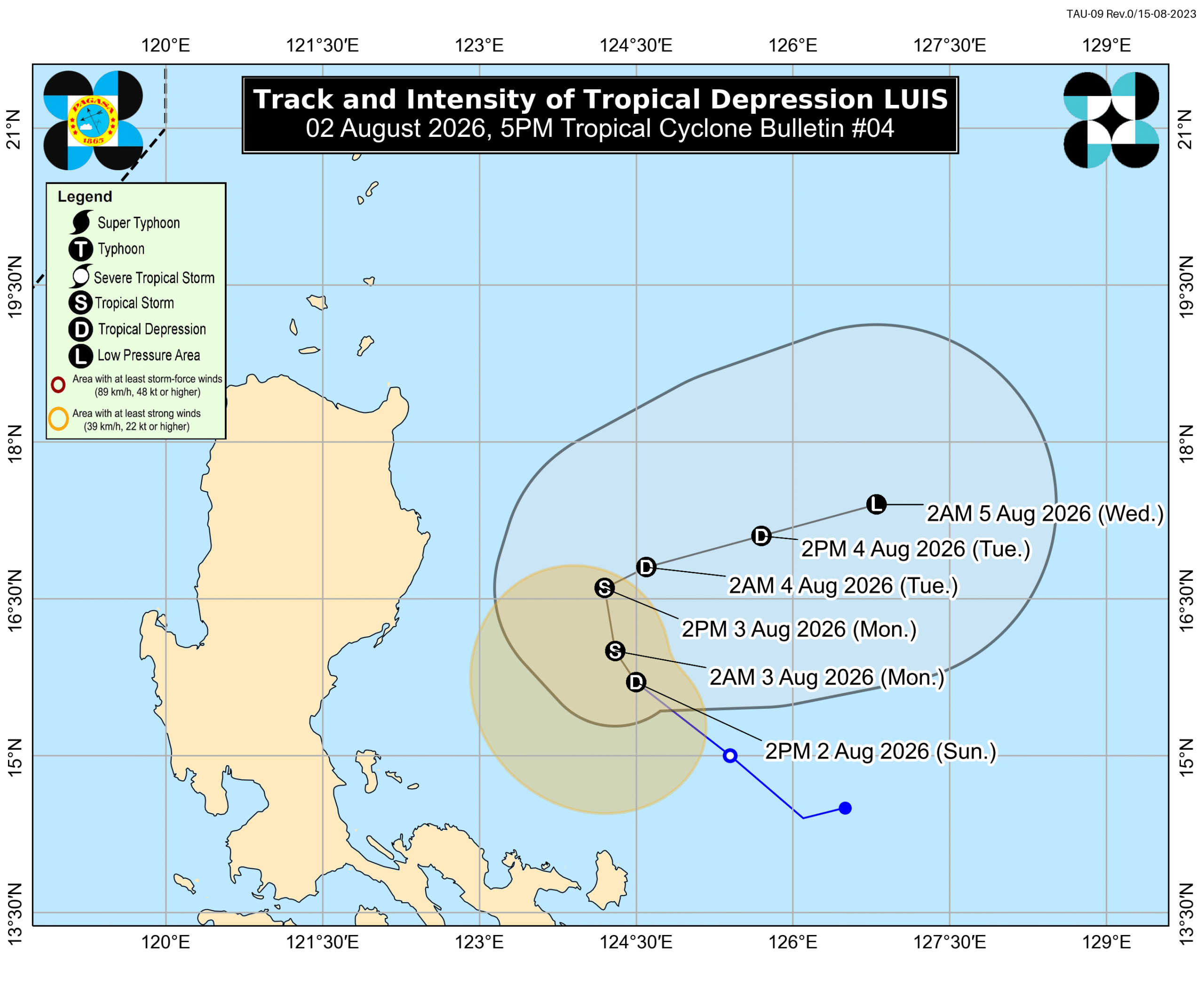
MANILA, Philippines – The weather bureau on Sunday afternoon, August 2, warned more areas to brace for significant rainfall from Tropical Depression Luis in the next couple of days. Luis was last spotted 285 kilometers east of Baler, Aurora, at 4 pm on Sunday. The tropical depression continues to move northwest at 15 kilometers per hour, with maximum sustained winds of 55 km/h and gustiness of up to 70 km/h. In a briefing past 5 pm on Sunday, the Philippine Atmospheric, Geophysical, and Astronomical Services Administration (PAGASA) said Luis is still likely to stay over the Philippine Sea. But it could go near or make landfall in Northern Luzon or Central Luzon if its track shifts westward. Luis might also strengthen into a tropical storm in a matter of hours, but it may weaken back into a tropical depression by Tuesday, August 4, and into a remnant low by Wednesday, August 5. Based on PAGASA’s updated rainfall advisory issued at 5 pm on Sunday, the following areas may be the most affected by Luis in the next 48 hours: Sunday afternoon, August 2, to Monday afternoon, August 3 Moderate to heavy rain (50-100 millimeters): Pangasinan, Cagayan, Isabela, Quirino, Zambales, Tarlac, Nueva Ecija, Bulacan, Aurora, Quezon Monday afternoon, August 3, to Tuesday afternoon, August 4 Moderate to heavy rain (50-100 mm): La Union, Pangasinan, Benguet, Isabela, Quirino, Aurora, Nueva Ecija, Bulacan, Tarlac, Pampanga, Zambales, Bataan, Metro Manila, Cavite, Batangas, Rizal Aside from the areas mentioned above, Luis is also affecting the rest of the Ilocos Region, the rest of Cagayan Valley, the rest of Central Luzon, the rest of Calabarzon, Metro Manila, Bicol, the Cordillera Administrative Region, Occidental Mindoro, Oriental Mindoro, Marinduque, Romblon, and Western Visayas on Sunday evening. Scattered rain and thunderstorms are expected to persist. Aside from Luis, the southwest monsoon or habagat will be another major source of rain in the coming week, as it will be enhanced by the tropical cyclone with the international name Dolphin, which is currently a typhoon outside the Philippine Area of Responsibility (PAR). Here is the latest rainfall outlook for the southwest monsoon: Moderate to heavy rain (50-100 mm): Occidental Mindoro Tuesday afternoon, August 4, to Wednesday afternoon, August 5 Heavy to intense rain (100-200 mm): Zambales, Bataan, Occidental Mindoro Moderate to heavy rain (50-100 mm): La Union, Pangasinan, Benguet, Tarlac, Pampanga, Bulacan, Metro Manila, Cavite, Rizal, Batangas, Antique Must Read [Walang Pasok] Class suspensions, Monday, August 3, 2026 Meanwhile, fewer areas are under Signal No. 1 due to Luis as of 5 pm on Sunday, as its strong winds are likely to remain mostly offshore: Polillo Islands Camarines Norte northern part of Camarines Sur (Caramoan, Garchitorena, Lagonoy, Tinambac, Siruma) northern part of Catanduanes (Pandan, Caramoran, Bagamanoc, Panganiban, Viga) PAGASA is not ruling out the possibility of raising Signal No. 2 if Luis becomes a tropical storm. The southwest monsoon and Luis’ periphery or outer bands are also bringing strong to gale-force gusts to these areas: Sunday, August 2 Marinduque, Occidental Mindoro, Oriental Mindoro, Romblon, Masbate, Sorsogon, Caluya Islands, Northern Samar, Samar, Biliran, Siquijor, Southern Leyte, Camiguin, Dinagat Islands Monday, August 3, and Tuesday, August 4 most of Luzon, most of Visayas, Lanao del Norte, Misamis Occidental, Camiguin, Surigao del Norte, Dinagat Islands, Sarangani, Davao Occidental, Davao Oriental In the next 24 hours, moderate to rough conditions are likely in the following seaboards: Eastern seaboard of Davao Oriental – waves up to 2.5 meters high Seaboards of Isabela, Surigao del Sur, and Davao Occidental; eastern seaboards of Cagayan, Catanduanes, and Northern Samar; northern seaboards of Aurora, Camarines Norte, Camarines Sur, and Catanduanes; remaining seaboard of Davao Oriental – waves up to 2 meters high Small vessels should take precautionary measures or avoid sailing, if possible. After weakening into a remnant low by Wednesday, Luis could become “fully assimilated” or absorbed into Dolphin’s circulation. The typhoon was located 3,100 kilometers east of extreme Northern Luzon as of 4 pm on Sunday, still moving west northwest at 25 km/h. It still has maximum sustained winds of 175 km/h and gustiness of up to 215 km/h. PAGASA Weather Specialist Grace Castañeda-Carpio said Dolphin appears “less likely” to enter PAR, but the weather bureau is not ruling out this possibility. What is more certain is that Dolphin will enhance the southwest monsoon. Luis is the Philippines’ 12th tropical cyclone for 2026, and the first for August. PAGASA earlier said two to four tropical cyclones could develop within or enter PAR during the month. – Rappler.com

0

Original source

Rappler Philippines

原文を読む