General articles are free for 24 hours after publish.
PAGASA Monitors 3 Weather Disturbances, Issues Rainfall Warning Over 7 Areas
The Philippine Atmospheric, Geophysical and Astronomical Services Administration (PAGASA) is monitoring three weather disturbances, issuing a heavy rainfall warning for several areas in Luzon due to the southwest monsoon. Risks of flash floods and landslides are elevated.
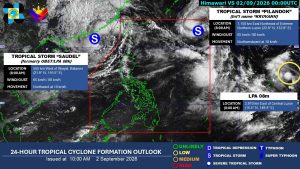
Three weather disturbances are being monitored on Wednesday, as the southwest monsoon continues to threaten Luzon, with heavy rainfall expected in seven areas, posing a risk of flash floods, according to the state weather bureau. The disturbance inside the Philippine Area of Responsibility (PAR), Tropical Storm Krovanh, locally known as Pilandok, was last located 1,135 kilometers east of Extreme Northern Luzon, the Philippine Atmospheric, Geophysical and Astronomical Services Administration (PAGASA) said in its 11:00 a.m. advisory. It maintained its strength of 65 kilometers per hour (kph) of maximum sustained winds and 80 kph of gustiness. “It is not directly affecting the country… It is also likely to exit PAR late (Wednesday) evening or early tomorrow morning,” Benison Jay Estareja said during the press briefing in Filipino. PAGASA is also monitoring Tropical Storm Saudel, formerly locally known as Obet, which was located 565 kilometers east-northeast of Itbayat, Batanes, with the same strength as Krovanh. Mr. Estareja said that the disturbance is diverting the moisture of the prevailing southwest monsoon toward its location. This causes rainfall to be concentrated along the western section of Luzon, based on PAGASA’s 11:00 a.m. weather advisory. “This is why heavy rainfall caused by the southwest monsoon is not that felt in Metro Manila and the southern part of Luzon,” Mr. Estareja said. PAGASA said that areas including Ilocos Norte, Ilocos Sur, La Union, Pangasinan, Abra, Benguet, and Zambales are expected to experience heavy rainfall, or rain between 50 to 100 millimeters, from Wednesday to Thursday noon. Similar areas are also likely to receive similar rainfall conditions until Saturday noon. PAGASA cautioned that under this rainfall condition, flooding and landslides are likely in high-risk areas. The bureau also monitored a low pressure area (LPA) that is likely to develop into a tropical depression within the next 24 hours and move near the PAR. — Edg Adrian A. Eva
Original source
BusinessWorld Nation