Typhoon Maysak Nears Ha Long Bay, Heavy Rains and High Waves Expected
Typhoon Maysak is approaching Vietnam's northeastern coast, with heavy rains and high waves anticipated from Saturday afternoon. Coastal areas face increased risks of flooding and landslides, prompting authorities to heighten vigilance.
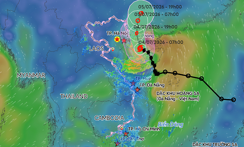
Tropical Storm Maysak is approaching Ha Long Bay off Vietnam's northeastern coast, with heavy rains and high waves expected from Saturday afternoon. According to the National Center for Hydro-Meteorological Forecasting, as of 8:00 a.m. Saturday, Maysak was centered approximately 55 km southeast of Bach Long Vi Island off Hai Phong City and 160 km southeast of Mong Cai in Quang Ninh Province. The storm is moving northwest at 15 kph, packing maximum sustained winds of 88 kph, with gusts reaching up to 117 kph. By 4:00 p.m. on Saturday, the center is expected to reach the waters off Quang Ninh, home to Ha Long Bay. The wind speed is anticipated to remain steady. Following this, the storm is forecast to turn north, traveling at 10–15 kph before making landfall in southern Guangxi, China, late Saturday or early Sunday. It will likely weaken into a tropical depression and eventually dissipate. International monitors note a similar path. The Japan Meteorological Agency reports current sustained winds of 72 kph, while the Hong Kong Observatory anticipates the storm will maintain winds of about 85 kph as it brushes past Mong Cai. Both expect the storm to retain its strength until reaching the border area. The storm's trajectory has notably shifted since Friday's forecasts. Instead of moving west-northwest at a slower pace of 7 kph, Maysak has accelerated to 15–20 kph, tracking north-northwest into the northern Gulf of Tonkin. Expected impacts Across the Gulf of Tonkin, including Bach Long Vi, Van Don, Co To, Cat Hai, and Hon Dau Island, strong winds of 39–61 kph are expected Saturday. Areas nearer the storm's center will face even stronger gusts. With waves forecast at 2–4 m, these hazardous sea conditions pose a severe threat to fishing vessels, cargo ships, and tourist boats. Maritime transport, aquaculture, and coastal infrastructure may face significant disruptions. Coastal regions of Quang Ninh, Hai Phong, and Hung Yen will experience winds of 39–49 kph, strengthening to 74 kph near the eye of the storm. Waves of 2–3 meters, combined with a storm surge of 0.2–0.4 meters, threaten to cause flooding at river mouths and low-lying coastal areas. Sea dikes, embankments, and transport networks are also at risk. The storm's circulation will bring heavy downpours to northeastern Vietnam, including Lang Son, Quang Ninh, Hai Phong, Bac Ninh, and Thanh Hoa, continuing through Sunday. Most areas will see 100–200 mm of rain. However, the broader northeast region may receive 200–300 mm, with some locations facing 500 mm. These downpours present a high risk of urban flooding, inundation of industrial parks, and severe flash floods and landslides in mountainous regions. Meteorologists warn that the storm's outer bands could spawn thunderstorms, tornadoes, and damaging wind gusts before and during landfall. Residents are urged to monitor the situation closely. The National Civil Defense Steering Committee and the Ministry of Agriculture and Environment have issued an emergency directive in response to the approaching storm. Northeastern provinces and Thanh Hoa have been ordered to account for all vessels and identify areas at high risk for flooding and landslides to prepare for potential evacuations. As of Thursday, authorities had successfully directed more than 56,200 vessels carrying nearly 250,000 people to safe shelter. In response to the escalating threat, Quang Ninh, Hai Phong, and Ninh Binh have imposed sea bans from Friday.
多角的分析
台風メーサークの接近は、ベトナム北東部の経済活動に短期的ながらも甚大な影響を与える可能性がある。特に、漁業、水産業、観光業は、高波や強風により直接的な被害を受けるリスクが高い。また、港湾の閉鎖や海上輸送の遅延は、サプライチェーンに混乱をもたらし、輸出入にも影響を及ぼす可能性がある。過去の台風被害を鑑みると、インフラへの損害も懸念され、復旧には相当なコストと時間を要するだろう。ベトナム経済の成長を支える製造業や農業も、洪水や土砂災害による生産停止のリスクを抱えている。
投資家にとって、この台風は短期的なリスク要因となる。特に、沿岸部のインフラや観光関連企業への投資は、一時的な損失や事業中断のリスクを考慮する必要がある。しかし、ベトナム経済の長期的な成長見通しに大きな影響を与えるものではないと考えられる。むしろ、災害からの復旧・復興に関連するインフラ投資や建設需要の増加は、新たな投資機会を生み出す可能性もある。ただし、気候変動による自然災害のリスクは、ベトナムへの投資における構造的なリスクとして認識しておくべきだろう。
台風メーサークは、ベトナム北東部の住民、特に沿岸地域や低地の住民の生活に直接的な脅威をもたらす。漁師や水産業従事者は、生計手段を失うリスクに直面する。また、豪雨による都市部の洪水や山岳地帯での土砂災害は、家屋の損壊や避難を余儀なくさせ、住民の安全と生活基盤を揺るがす。過去の災害でも見られたように、インフラの脆弱性が、被災者の苦境をさらに深刻化させる要因となる。当局による避難指示や船舶の安全確保は、被害を最小限に抑えるための重要な措置であるが、その実効性は地域住民の協力とインフラの整備状況に左右される。
沿岸部で漁業を営む人々は、漁船の安全確保や漁獲量の減少に直面し、生計への影響を懸念している。ハロン湾周辺の観光業者は、観光客のキャンセルや施設の被害を心配しているだろう。また、北東部の都市部住民は、突然の豪雨による道路冠水や自宅への浸水を警戒し、安全な場所への避難を検討する必要に迫られる。山間部に住む人々は、土砂崩れの危険に常に晒されており、過去の災害の記憶が蘇ることも考えられる。当局の指示に従いつつも、日々の生活への影響を最小限に抑えるための対策に追われることになる。
背景・歴史的文脈
ベトナムは、東南アジアに位置し、長い海岸線を持つため、台風や熱帯低気圧の影響を頻繁に受ける国である。特に北東部は、トンキン湾に面しており、台風の進路になりやすい地域だ。過去にも、2017年の台風ダマス(Damrey)や2020年の台風リンファ(Linfa)、サイフェン(Saudel)など、甚大な被害をもたらした台風がベトナムを襲っている。これらの災害は、インフラの脆弱性、特に沿岸部の堤防や排水システムの不足、および山岳地帯での土砂災害のリスクを浮き彫りにしてきた。ベトナム政府は、これらの自然災害への対応として、早期警報システムの強化、避難計画の策定、インフラ整備への投資を進めているが、気候変動による災害の激甚化が、その対策を上回るペースで進んでいるのが現状である。
原文ソース
VnExpress International