General articles are free for 24 hours after publish.
Nepal Floods: Was Information Sharing Slow to Blame for Massive Death Toll?
A massive flood in Nepal has resulted in a significant death toll, with some blaming China for slow information sharing. However, others point to Nepal's own lack of proactive follow-through. Experts highlight the vulnerability of Nepal's early warning infrastructure as a fundamental issue.
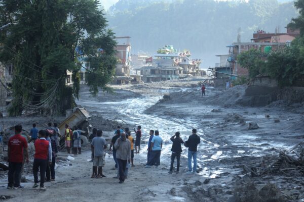
Read The Diplomat, Know The Asia-Pacific The problem wasn’t China or a lack of data; it was Nepal’s lack of follow-through. People gather to look at the damage after a massive flood in the Bhotekoshi River in Nuwakot, Nepal, Aug. 28, 2026. When a massive flood hit Nepal on August 26, Nepali social media split almost immediately into two camps of grief and anger. One camp blamed the government of China, saying hundreds of Nepalis – over 1,400 as of the last count – died because the warning had simply failed. Commentators accused China of sitting on satellite and disaster monitoring data that could have bought Nepal precious minutes of warning. A second, more painful narrative came from survivors and local officials themselves: yes, the word had reached them that flood was coming down. There simply wasn’t enough time to react before the disaster arrived. China’s embassy in Kathmandu called the claims that it had withheld information “completely false and misleading,” insisting Beijing shared information with the Nepali side in time. But the strongest pushback on the blame narrative didn’t come from Beijing at all, but from Nepal’s own disaster authority, the National Disaster Risk Reduction and Management Authority (NDRRMA). “There have been several discussions. Actually, Chinese approached the Nepal government several times,” NDRRMA director Dr Prakash Pokhrel told me. “The Nepali side needs to be more proactive to finalize the data sharing agreement.” In other words, the problem wasn’t China refusing to share data. It was Nepal not following through. Days after the flood, researchers from the Chinese Academy of Sciences’ Institute of Mountain Hazards and Environment published a technical reconstruction of the disaster. They found that a glacier in Langtang Lirung’s south slope, at roughly 5,200 meters in elevation, had fractured at 10:52 a.m. China time (8:47 a.m. in Nepal), sending an ice-rock avalanche that scoured downhill and grew into a debris flow. It covered 22 kilometers and reached Gyirong Port on the Chinese side of the border in about seven minutes, an average speed of nearly 50 meters a second. Researchers said the debris was moving fast enough to leave people almost no time to react regardless of what anyone knew in advance. Chinese Academy of Sciences researcher Su Pengcheng attributed the collapse to long-term glacier instability driven by climate warning, not to any specific weather pattern that could have been tracked and disclosed in advance. Three weeks after the disaster, Nepal’s disaster authorities are still revising the death toll upward, with over 1,400 bodies recovered and 6,000 still missing on the Nepali side alone. Dozens more are dead or missing in Tibet. The disaster might not be over. A barrier lake at the collapse site remains, according to both governments, and a second flood is still possible. Arguments over who knew what and when still continue, but the ongoing debate is hiding harder questions: can Nepal actually monitor hazards like this in real time on its own terms? Or does it keep failing at early warning in disaster after disaster because Nepal depends on satellite and monitoring infrastructure – none of which Nepal owns itself? Nepal is fast becoming one of the world’s most disaster-exposed regions, and that makes the question of sovereign space and monitoring capacity impossible to keep deferring. Satellite systems underpin flood warnings, cyclone alerts, navigation, communication, and climate monitoring functions on which the safety of hundreds of millions of people across the Himalayan region now depend. Warning Signs Were Flagged The August 26 flood and landslide was the third major glacier-linked disaster to hit almost exactly this region in roughly 14 months. In May 2025, two glacial lakes above Tilgau village in Humla burst. There was no rainfall recorded at all; the flood was purely a glacial trigger. In July 2025, a super glacial lake atop the Purepu Glacier drained into same Lende River hit by the August 2026 flood, The July 2025 event killed at least nine people in Nepal with 19 more missing. It destroyed the same Miteri Bridge at Rasuwagadhi and damaged the same hydropower plants and highways that August’s flood would later hit again. Chinese researchers later reconstructed that event too. According to imagery from China’s Gaofen-7 satellite, the lake had expanded more than sevenfold in two months before it burst. All three disasters involved the same tributary system, the same border, and the same fundamental problem. More importantly, all were monitored by excellent forensic satellite science, but the warning signs weren’t shared with people on the ground before the disaster. That was true with the August 26 flood as well. Researchers using Sentinel-1 radar data found the glacier rock mass was speeding up a week before it actually broke. None of that imagery helped anyone evacuate. Nepal’s Department of Hydrology and Meteorology wasn’t notified until roughly 9:00 a.m., about 20 minutes after the flood had begun. Remember, the debris flowed reached Gyirong in just seven minutes. By the time Nepal’s government was aware of the diaster, most of the communication towers in the area were already gone and officials had shifted to door-to-door warnings. The evacuation also failed because Nepal’s warning architecture could only react once a hazard had already reached the first river gauge downstream – and this time, the gauge was destroyed before it had time to register a flood. Nepal’s gauges measure water height, not how fast the water rises and this avalanche-driven surge rose far faster than the system was built to detect. As each station was destroyed while still showing normal levels, the flood went unnoticed until it reached Malekhu. Early Warning Infrastructure Nepal Doesn’t Own To truly see the next flood coming, Nepal needs access to satellite imagery. If the disaster authority could monitor the condition of glaciers and glacial lakes, the country would know which areas are in danger. But that’s a tall order for Nepal, as NDRRMA director Pokhrel noted. Building Nepal’s own satellite, he told me, is “ambitious and very expensive.” A more realistic step for now is paying for clear satellite images that catch specific mountainsides destabilizing in real time. Nepal’s free access to Landsat and Sentinel doesn’t cover this. Those satellites give moderate resolution images and revisit a given slope only every five to 16 days. What Pokhrel wants is the other tier: high resolution, frequently revised commercial imagery, which Nepal currently only gets for free after a disaster through emergency mechanisms like Corpernicus’s Emergency Mapping Service. Nepal has no access to these images before a disaster, when it could actually help. As it stands, Nepal’s operational forecasting tools are largely built and hosted by other countries. Nepal’s International Centre for Integrated Mountain Development
Original source
The Diplomat Indonesia