Super Typhoon Bavi Nearing Philippine Area of Responsibility; Signal No. 3 Possible
Environment
2026年7月7日
3
BusinessWorld Nation

Super Typhoon Bavi Nearing Philippine Area of Responsibility; Signal No. 3 Possible

AI サマリー

Super Typhoon Bavi is forecast to enter the Philippine Area of Responsibility (PAR) by early next week, with Storm Wind Signal No. 3 potentially hoisted in some areas. While direct landfall is unlikely, strong winds are expected to affect a wide region.

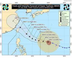
Super Typhoon Bavi (international name) may enter the Philippine Area of Responsibility (PAR) as early as Tuesday evening, prompting the hoisting of Storm Wind Signal No. 3 in some areas, according to the Philippine Atmospheric, Geophysical and Astronomical Services Administration (PAGASA) on Tuesday. “Super Bavi is forecast to move generally west-northwestward and will enter PAR between this evening and tomorrow early morning,” PAGASA said in its 11:00 a.m. tropical cyclone advisory. Once Bavi enters PAR, it will be assigned the local name Inday, the country’s ninth tropical cyclone of 2026. As of 10:00 a.m., the super typhoon was last located 1,845 kilometers east of Central Luzon. It slightly weakened, packing maximum sustained winds of 185 kilometers per hour (kph) and gusts of up to 230 kph. Although Bavi is not expected to make landfall in any part of the country, PAGASA said the intensity and the extent of its strong winds may still prompt the hoisting of storm wind signals, with the highest expected to range between Signal No. 2 and Signal No. 3 in several areas. Storm wind signals may be raised over parts of Southern Luzon and the Visayas due to the uncertainty surrounding the extent of the super typhoon’s strong winds. Strong to gale-force wind gusts are already expected to be experienced across most of Mindanao on Tuesday due to Bavi’s periphery and the effects of the enhanced southwest monsoon, PAGASA said. These conditions are expected to affect more areas in the coming days. As for Bavi’s forecast track, the super typhoon is expected to move generally northwestward toward the Ryukyu Islands and maintain its strength as it approaches PAR. It is then expected to gradually weaken as it moves near Extreme Northern Luzon while approaching eastern Taiwan. PAGASA continues to remind the public and local disaster risk reduction and management offices to monitor updates regarding the tropical cyclone. — Edg Adrian A. Eva

多角的分析

経済的影響

台風の接近は、農産物への被害、漁業への影響、そしてインフラの損傷を通じて、フィリピン経済に短期的な打撃を与える可能性がある。特に、影響を受ける可能性のあるルソン島南部やビサヤ諸島は、農業や観光業が盛んな地域であり、サプライチェーンの混乱や観光客の減少が懸念される。過去の台風被害の事例では、復旧には数週間から数ヶ月を要し、GDP成長率に影響を与えることもある。

投資家心理

投資家にとっては、台風によるインフラ被害やサプライチェーンの寸断リスクが懸念材料となる。特に、農業関連企業や運輸・物流セクターは直接的な影響を受けやすい。一方で、復旧需要に伴う建設関連企業や、防災・保険関連サービスへの投資機会も生まれる可能性がある。しかし、不確実性が高まるため、短期的な投資判断は慎重になるだろう。

社会的影響

台風「バビ」の接近は、フィリピン国民、特に低所得者層や沿岸部の住民にとって、直接的な生活への脅威となる。避難生活を強いられる人々、住居や財産を失うリスクを抱える人々の不安は大きい。また、交通機関の麻痺は、通勤・通学に影響を与え、物流の滞りは食料品や生活必需品の価格上昇を招く可能性もある。過去の台風災害では、脆弱なインフラを持つ地域での被害が甚大化する傾向が見られる。

市民の声

マニラ首都圏では、直接的な強風の影響は限定的かもしれないが、物流の遅延による物資不足や価格上昇が懸念される。地方では、住居の損壊や農作物への被害が現実的な問題となる。特に、インフラが脆弱な地域では、停電や通信障害が長期化する可能性があり、住民の不安は増大する。過去の経験から、台風通過後の復旧作業の遅れや支援の不足が、住民生活にさらなる負担を強いることが危惧される。

背景・歴史的文脈

フィリピンは、太平洋の「火の輪」上に位置し、世界で最も台風が頻繁に発生・上陸する国の一つである。年間平均20個以上の熱帯低気圧がフィリピン大気圏内(PAR)に入り、そのうち数個は甚大な被害をもたらす強大な台風となる。特に、2013年の台風ヨランダ(ハイエン)のような壊滅的な被害は、フィリピンの脆弱なインフラと、気候変動による異常気象の激化が、国民生活に深刻な影響を与えることを示している。政府は、防災体制の強化やインフラ投資を継続的に進めているが、自然災害への対応は常に喫緊の課題となっている。

原文ソース

BusinessWorld Nation

原文を読む